

NJ to experience close call with tropical system this week
The system likely to become Tropical Storm Irma is forecast to pass about 200 miles of the Jersey Shore on Tuesday.
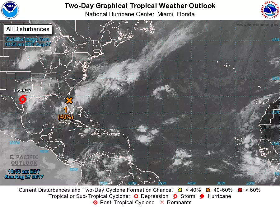
You may have heard about the potential for a tropical storm passing very close to New Jersey in the coming days. True, there is a tropical disturbance currently centered over northeastern Florida. True, it is forecast to pass in between the U.S. East Coast and Bermuda between about Tuesday and Wednesday. True, my eyebrows are raised.
But there is no need to ring alarm bells at this time. My purpose in authoring this special weekend-edition of the MDZ weather blog is to: 1.) communicate the current forecast (what we know, and what we don't), 2.) quell some of the inevitable hype, and 3.) assure you that we're monitoring the situation carefully.
What to Call It?
Honestly I'm unsure what to call this thing, to ensure clarity, accuracy, precision, and no-hype. For now, I'm going with "tropical disturbance" or the always-useful "coastal storm". There is a good chance (40 to 50 percent, according to the National Hurricane Center) this storm system becomes a tropical storm in the coming days. The next name on the list is Irma.
Timing
The tropical disturbance is expected to pass closest to the Garden State from Tuesday afternoon to Wednesday morning. As of this writing, that's between about 48 and 72 hours away.
Forecast Track
In forecasting tropical cyclones, we utilize a tool called a "spaghetti plot". This map shows multiple weather model tracks at once, with helps us analyze where the center of a storm is most likely to go over time.
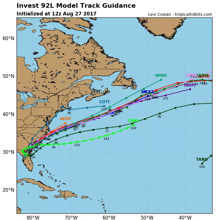
See that thick grouping of model paths that pushes the storm out to sea beyond the Outer Banks of North Carolina? Consensus! In other words, the large abundance of forecasts will keep the storm's center about 200 miles southeast of New Jersey.
There is one outlier to the south, the TABS model from Texas A&M. And yes, the Navy's COTI model is a northern outlier that puts the center of the storm over the the Jersey Shore. Do I believe such a solution? Nope. It's worth watching for any potential surprises and track wiggles perhaps, but the consensus here is pretty solid.
A Very Important Note
Keep in mind, a storm is bigger than just a dot or a line on a map. The plot above represents the expected track of the center of this storm. Elevated winds, tropical rain bands, and substantial swell and surge can extend for hundreds of miles from the center of the storm. So, even though a direct hit is unlikely, New Jersey may still experience some weather and surf impacts.
Rain
The further the center of the storm stays from New Jersey, the sparser the rain bands will be. Just to give you some rough numbers, I'd currently estimate rainfall of about 0.25" to 0.5" for inland NJ and 0.5" to 1.0" along the Jersey Shore. As the situation stands right now, no big deal.
Wind
It's going to get breezy. Maybe even windy, especially at the coast. We could see gusts to about 30 mph. Again, not really pleasant, but winds are not expected to become fierce enough to cause widespread damage, power outages, etc.
Keep in mind that a brisk on-shore flow (easterly wind) like this would almost certainly deliver increased cloud cover and therefore cooler temperatures.
Down the Shore
Any time there is a sizable storm in the Atlantic Ocean (tropical or not), we have to watch the waves. Even if the storm stays several hundred miles out to sea (as forecast), we could still see some swell along the Jersey Shore.

Early predictions call for only about 1 foot of surge and ocean waves about 3 feet higher than normal. Additionally, the rip current risk will almost certainly rise with rougher surf conditions.
The Bottom Line
Overall, in my expert meteorological opinion, we find ourselves in a pretty good situation. The storm will most likely be a marginal tropical storm, and our astronomical tide this week will be manageable. However, the numbers I've presented here are highly sensitive to the strength, orientation, and track of the storm. Again, we'll be watching very very carefully.
Next weather blog update will be posted by 7 a.m. Monday morning.
Dan Zarrow is Chief Meteorologist for Townsquare Media New Jersey. Follow him on Facebook or Twitter for the latest forecast and realtime weather updates.
More From New Jersey 101.5 FM


