
Quick hit of healthy snow: 8 things to know about Sunday’s nor’easter
UPDATE... This article is outdated...
For the latest winter storm forecast information, please refer to my newest weather blog post.
1.) What are the latest developments?
Three pieces of this forecast have changed since I last blogged Friday evening:
1.) The storm has taken a little shift ("wiggle") to the northwest, closer to the coast.
2.) Rain/mix looks more pronounced along the coast, limiting snow accumulation.
3.) Overall, the storm looks slightly weaker, which may limit the time and intensity of heaviest snow.
2.) When will the storm arrive?
The storm timeline generally follows the same idea I've laid out previously, although I have pushed the brunt and end times slightly later.
—Start... 2 a.m. to 6 a.m. Sunday (primarily rain/mix at onset, south and coast)
—Brunt... 8 a.m. to 2 p.m. Sunday (heaviest snow bands at this time)
—End... 2 p.m. to 6 p.m. Sunday (tapering west to east)
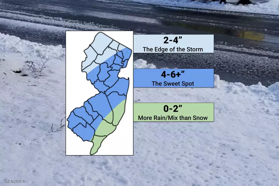
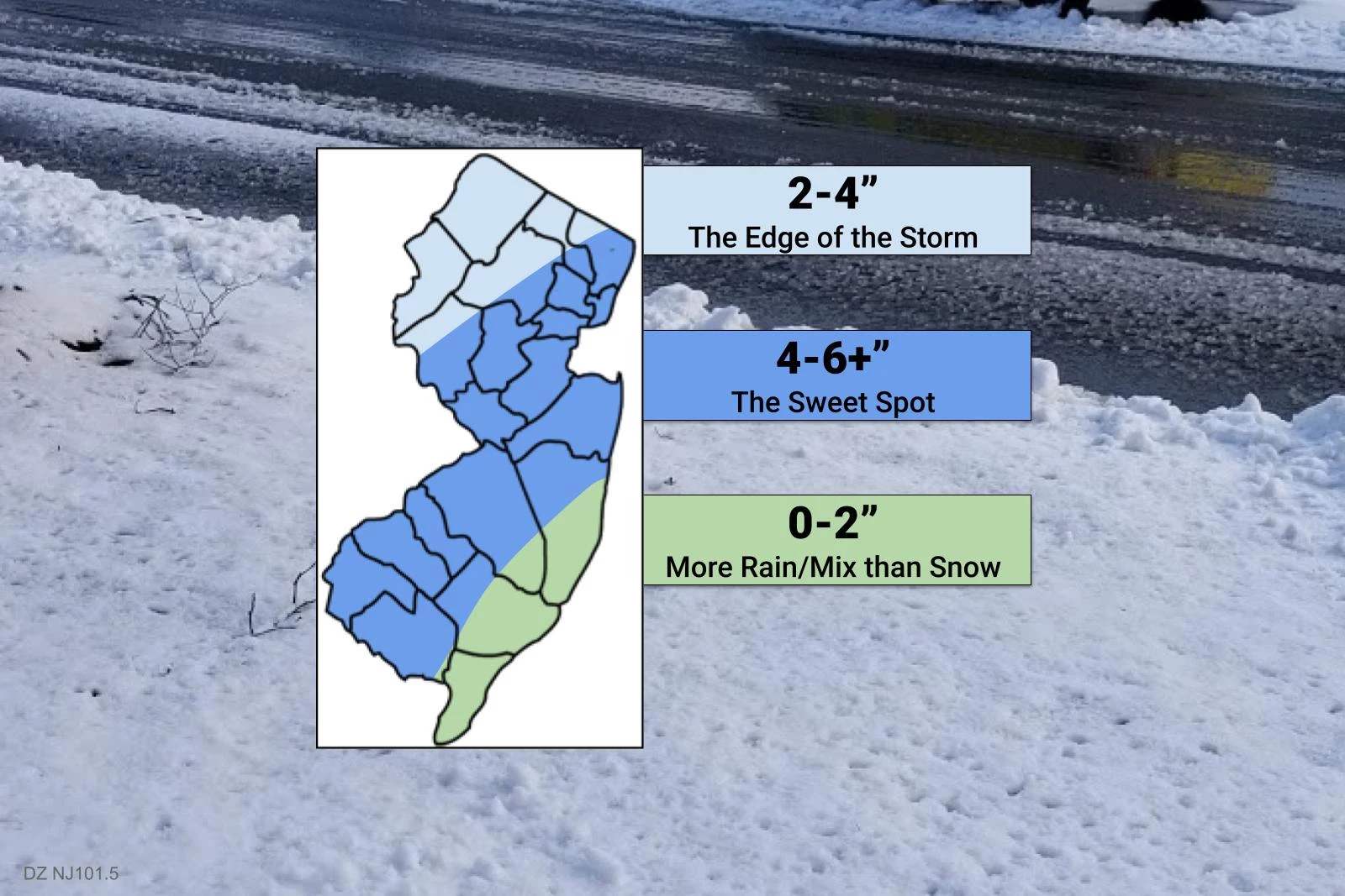
3.) Where's the snow bullseye?
The keys to success for this forecast are figuring out:
1.) Who will get wintry mix or straight rain, and how long will it last?
2.) Who will see the heaviest snow bands?
My newest snow map (above) is my estimate of how those two factors will play out.
—The Sweet Spot... It looks like the NJ Turnpike corridor through inland southern and central New Jersey will see the heaviest snowfall and 4 to 6+ inches of snow accumulation. (Behind the scenes, I debated labeling this area 4-8" or even a straight ~6". I wouldn't rule out 8" of snow in spots — there are even outlier scenarios as high as 10" or 12" — but I'm thinking the mixing issue and banding uncertainty make 6" a much more likely estimate for widespread snowfall.)
—Too Warm at the Coast... While our initial snow predictions looked hopeful for snow lovers along the Jersey Shore, it's pretty clear now that rain and wintry mix will ultimately squash those wintry dreams. I expect the green zone of the map to see mainly rain and/or slushy mix from onset through about noon Sunday, missing out on most of the storm's "brunt". There is a chance for all snow in the afternoon, with limited accumulations possible given the light snowfall intensity and the wet ground at that time.
—North Jersey Too Far... Far northern New Jersey will be spared the worst of this coast hugger storm. You'll still see some snow, on the order of 2 to 4 inches. But the heaviest snow should stay south — not a guarantee, but that's where model consensus is pointing.
4.) What about the wiggle factor?
No forecast is complete without a measure of confidence, a statement of how "locked in" the predicted scenario is.
In this case, I'd say confidence is high that we're going to see moderate to heavy snow accumulations across much of New Jersey. The storm would have to wiggle a lot for it to be a complete miss.
Confidence is medium that snow totals will mirror the map I drew above. If heavy mesoscale snow bands set up 25 miles in either direction, that will obviously affect who sees the most snow. If temperatures (either at the surface or aloft) are just a few degrees off from expectations, we could see more (or less) mixing along coastal areas.
So the forecast is clearer than it had been, for sure. And the fact remains that widespread 6-inch snow will always carry significant wintry impacts. But let's also remember that this forecast is still very sensitive to the exact track of the storm, which is indeed still subject to wiggling.
5.) What warnings and advisories have been issued?
The National Weather Service has issued a Winter Storm Warning for the following times and counties:
—4 a.m. Sunday to 7 p.m. Sunday... northwestern Burlington, Camden, Gloucester, Hunterdon, Mercer, Middlesex, western Monmouth, Morris, Salem, and Somerset counties.
—6 a.m. Sunday to 9 p.m. Sunday... Bergen, Essex, Hudson, eastern Passaic, and Union counties.
A less-severe, less-urgent, less-hazardous Winter Weather Advisory is posted for:
—4 a.m. Sunday to 7 p.m. Sunday... Atlantic, southeastern Burlington, Cape May, Cumberland, coastal Monmouth, Ocean, Sussex, and Warren counties.
—6 a.m. Sunday to 9 p.m. Sunday... western Passaic county.
6.) Any wind or coastal flooding?
Nope.
Wind gusts may approach 30 mph, especially after the storm as arctic air whooshes in from the northwest.
The storm will be moving so quickly that it won't have an opportunity to churn up our ocean. Storm surge of a few inches shouldn't cause any coastal flooding issues. (Especially since our astronomical tide is relatively low right now, due to a waning crescent moon.)
7.) What's the bottom line?
It's going to snow. It is a fast-moving storm system, in and out within about 12 hours. Expect wintry weather early Sunday morning through part of the afternoon. That snow will be heavy for a time, away from the coast. Certainly shovelable for most of the state. Probably plowable.
Travel will be difficult during the height of the storm, due to low visibility and poor traction. Hopefully crews will have enough time to clean up the snow by Monday morning's commute. (Keep in mind, plowing operations will take much longer in areas with a foot of snow already on the ground from Monday's storm.)
I suspect impacted schools would lean more toward a delayed opening (or virtual learning day) situation, if anything, rather than a straight "snow day" closing. (Sorry kiddies.) For any decision-makers reading this, you should make that call as last-minute as possible, based on your own local conditions and policies Sunday evening and/or Monday morning.
8.) What's next?
For the third weekend in a row, I'm stepping into the weather center for the weekend. ('Tis the season!) I look forward to bringing you the latest forecast before and during this winter storm, on the 14 stations that comprise the Townsquare New Jersey Weather Network.
This may be my "final call" forecast. If there are big changes, I will put together another update post either Saturday evening or early Sunday morning. Keep an eye on social media for additional insight too.
Our news team has assembled, ready to update you on road conditions, power outages, and government advisories.
Enjoy Saturday's lovely weather, and I'll see you real soon.
Dan Zarrow is Chief Meteorologist for Townsquare Media New Jersey. Follow him on Facebook or Twitter for the latest forecast and realtime weather updates.
NJ snowfall totals for Jan. 31-Feb. 2 storm
More From New Jersey 101.5 FM


