

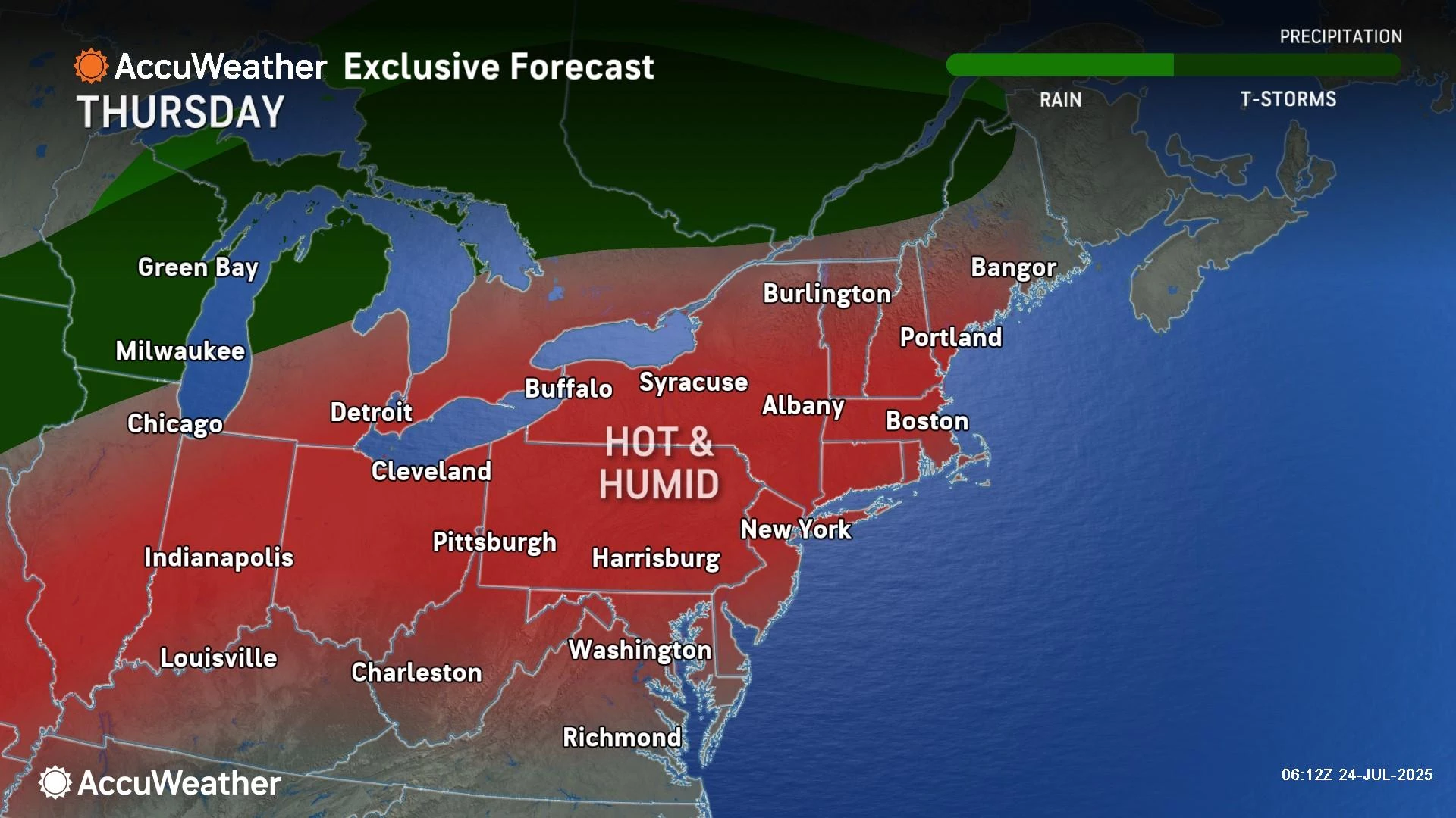
Nice and warm Thursday, double alarm bells for heat and storms Friday
In general, this has been a great weather week across New Jersey. Well, Thursday will be the grand finale of "nice" weather in this stretch, and the forecast reads like a typical mid-summer day. Lots of sunshine, a light breeze, moderate humidity, temperatures well in the 80s. Heat warnings and advisories are already posted for Friday, as dangerous heat and humidity return to New Jersey. Expect highs in the 90s and a heat index in the triple digits, plus a few strong thunderstorms potentially probably popping up starting tomorrow late afternoon. The weekend will not be as hot, but it will be summery. Each day will carry a thunderstorm chance, especially Sunday.
Thursday NJ weather: Great beach day
Thursday will be about five degrees hotter than Wednesday. With dew points in the 60s, humidity can no longer be described as "low" — let's call it moderate. All signs are pointing to a typical, pleasant summer day with seasonable temperatures and a nice, bright sky. There's really nothing to complain about here.
Expect mostly sunny skies and dry weather throughout your Thursday. We are starting the day with temperatures mainly in the 60s. Highs will reach about 85 to 90 degrees — typical for late July. The Jersey Shore will end up about 10 degrees cooler, thanks to a sea breeze. Sounds like a great beach day to me!
Thursday evening will be pleasant, although humidity levels will start to creep upward overnight. That means it will be a bit muggier and less comfortable through Friday morning. Look for low temperatures in the lower 70s — not the 60s this time around.
Friday NJ weather: Ferocious heat, potential thunderstorms
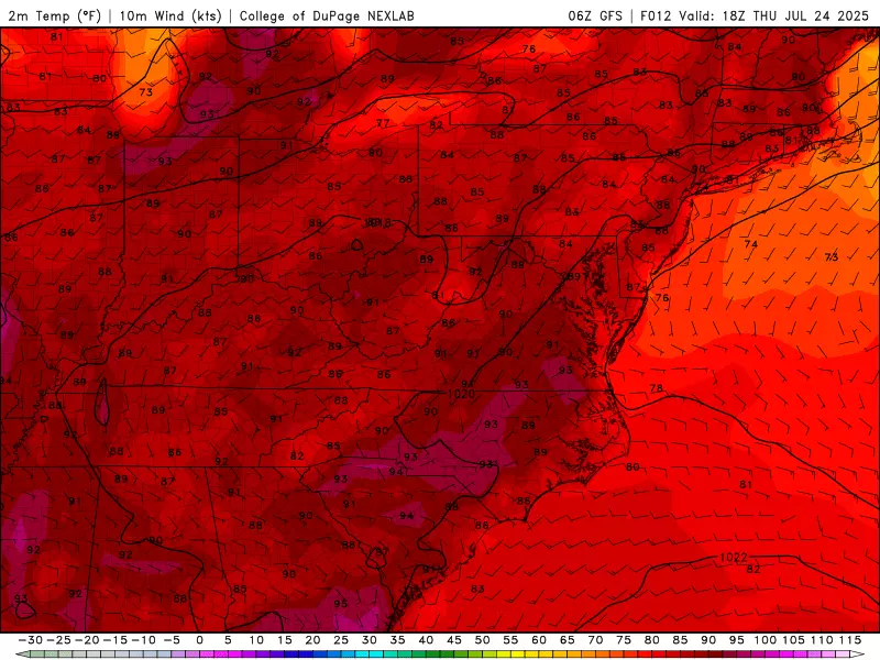
Friday will be upwards of ten degrees hotter than Thursday, with a big ramp-up in humidity too. Now there's something to complain about.
I'm thinking about what I have to do differently when the weather progresses from the "regular heat" to the "dangerous heat" category. Specifically, two of my kids are attending an all-day outdoor summer camp this week. We are going to dress them in loose-fitting clothes. We are going to send them with extra icy drinks and a light lunch. They have been loving cooling towels in their lunchbox. And I am sure the counselors will keep things nice and easy-going in the thick, soupy air. You really have to take care of yourself when summer turns truly sweltering.
High temperatures on Friday will reach the mid 90s for most of the state. The Jersey Shore, especially on barrier islands, will catch some relief. Factoring in high humidity, the heat index (the "feels like" or "apparent" temperature) will end up around 100 to 106 degrees. Blech. Disgusting, downright dangerous heat.
The National Weather Service has issued an Extreme Heat Warning for approximately the NJ Turnpike corridor between Philadelphia and New York for Friday. It includes the following 11 full/partial counties: Gloucester, Camden, northwestern Burlington, Mercer, Somerset, Middlesex, Union, Essex, Hudson, eastern Passaic, and Bergen.
A Heat Advisory is in effect for Friday for the rest of the state: Atlantic, southeastern Burlington, Cape May, Cumberland, Hunterdon, Monmouth, Morris, Ocean, western Passaic, Salem, Sussex, and Warren.
Honestly, the difference in criteria and impacts between the warning and advisory are subtle and practically irrelevant. Everyone is going to sweat. Everyone is going to swelter. Please take the heat seriously.
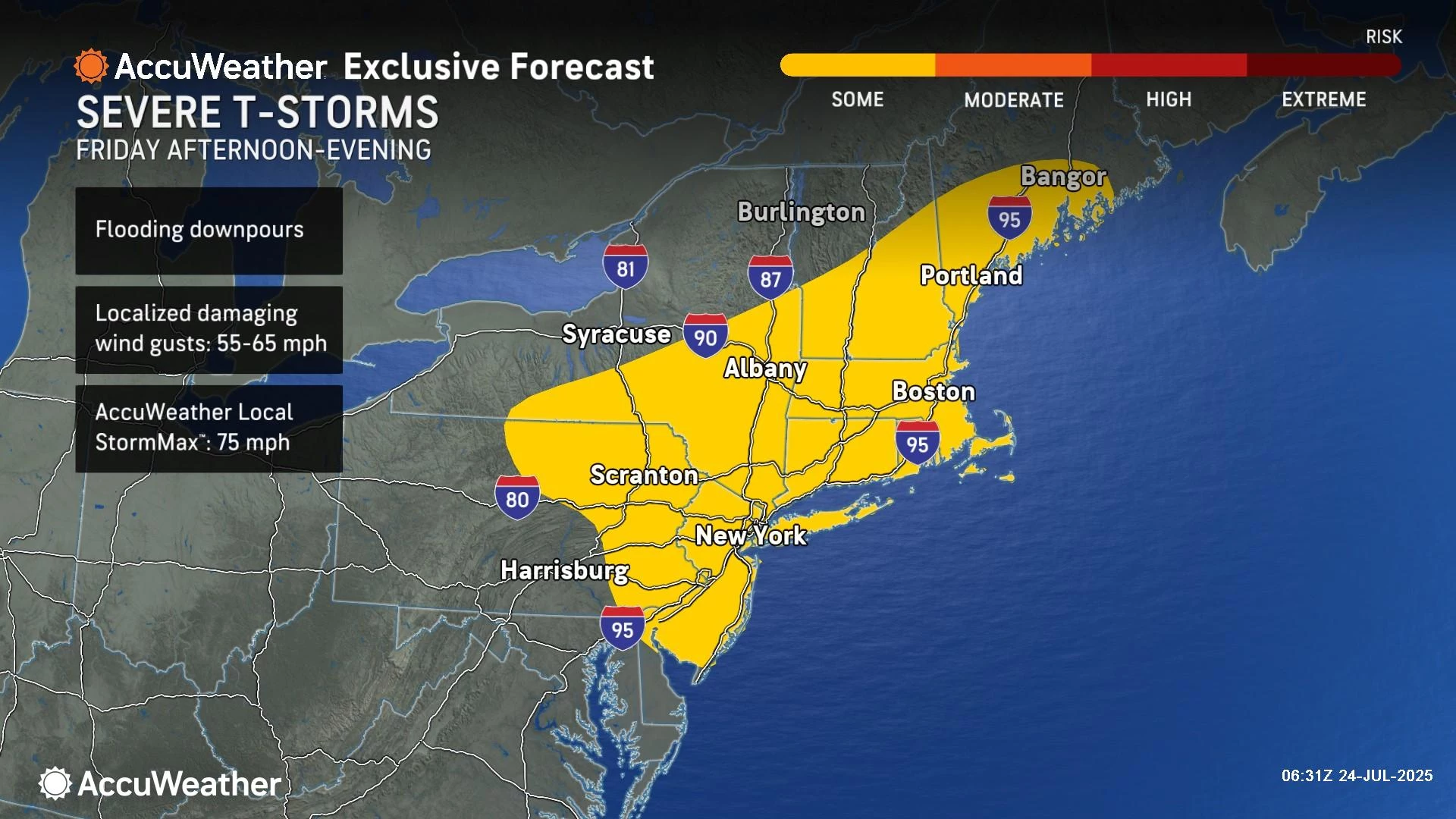
Weatherwise, we will see plenty of hazy sunshine early on Friday, before clouds build in the afternoon. A stiff southwesterly breeze will act as a "blast furnace," transporting the hot air into New Jersey.
And then, as a cold front pushes in, we will have to watch the sky for — you guessed it — thunderstorms. Given the extreme heat and humidity in the air, it should be no surprise that storms will be on the strong side, with gusty winds, downpours, and lots of lightning our biggest concerns. Timing of potential storms will be about 3 p.m. to 9 p.m. Friday.
But here's the thing. Not everyone in New Jersey will see a storm. They will be spotty. They will break apart as they travel south and east. Having said that, it is absolutely worth sounding the alarm and staying #WeatherAware given the threat of severe weather. But just understand storms are not a guarantee late Friday.
Saturday NJ weather: Not as hot
Earlier this week, the weekend forecast did not look so good. But it's looking better now. Certainly better than Friday.
Saturday will not be as hot as Friday, that's for sure. I'll call it warm, with highs in the mid 80s or so. It will be fairly humid, with dew points in the 60s. Overall, that's not too bad for a summer day.
Sunshine will be limited at times. And I can't rule out a few isolated showers or thunderstorms right in the middle of the day. But the vast majority of the day and the vast majority of the state should stay dry and problem-free. Again, not too shabby.
Sunday NJ weather: The more unsettled day of the weekend
Yes, Sunday will not only be more unsettled, it will be hotter too.
High temperatures will push to around 90 degrees away from the coast on Sunday. Skies will become mostly cloudy.
Forecast models are showing two opportunities for some inclement weather on Sunday. First, a shower or thunderstorm may clip North Jersey in the morning. And then, a more widespread round of spotty thunderstorms late-day, in that classic "3 p.m. onward" time frame.
I do not want to nail down storm timing and impacts too much, since it's still 3 days / 72 hours away. But just know thunderstorm potential is there for Sunday. And once again, since it will be a hot and humid summer day, those storms could have some teeth.
Monday NJ weather: Hot end to July
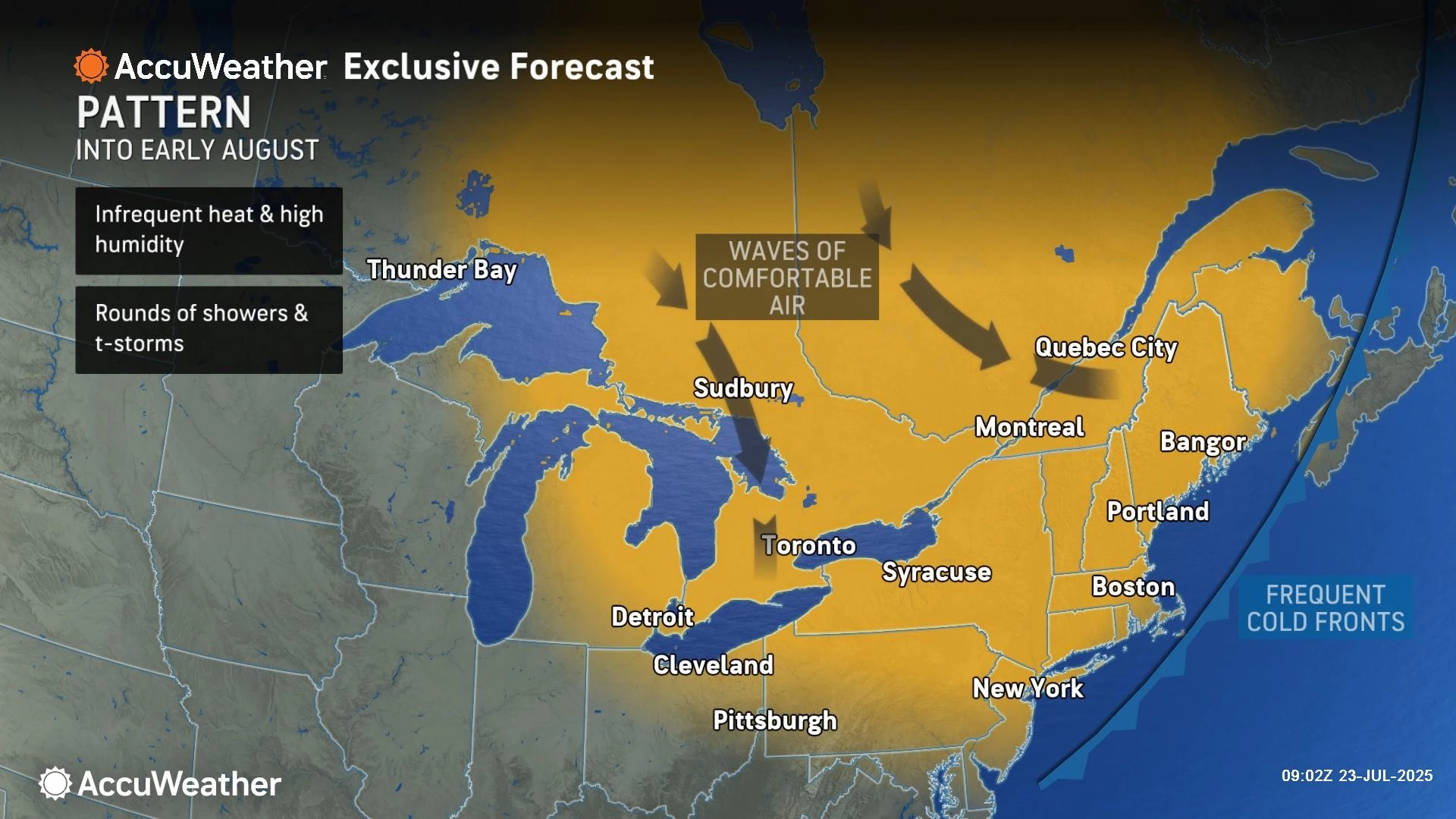
Although there is some variation in the exact numbers among model guidance for next week, the final few days of July generally look hot. More 90s than anything else. Will we have to raise flags for "dangerous" heat and humidity? We will see — at the moment, humidity levels do not look too tropical.
There will probably be a round of midweek thunderstorms, ushering in a cooldown. Long-range model forecasts for early August have trended seasonable and quiet for a while now. I'd love to see another stretch of pleasant, non-humid weather — always a treat here in the "dog days of summer".
26 of the Dumbest Laws in New Jersey
Gallery Credit: Matt Ryan
Dan Zarrow is Chief Meteorologist for Townsquare Media New Jersey. Follow him on Facebook for the latest forecast and realtime weather updates.
The 20 Most Beautiful Towns In New Jersey
Gallery Credit: Lou Russo
More From New Jersey 101.5 FM


