

Two big weather concerns for NJ Friday: Heat and thunderstorms
The Bottom Line
After so many days and weeks of beautiful weather, there is a lot going on in this weather forecast.
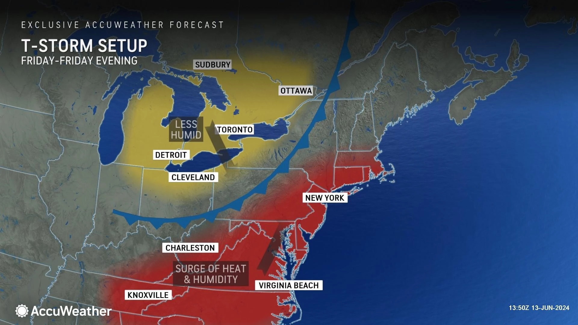
Friday features a taste of real sultry, stormy weather. High temperatures soar to 90, as humidity creeps upward. We will have to watch the sky later on, as a cold front sparks a line of strong to severe thunderstorms.
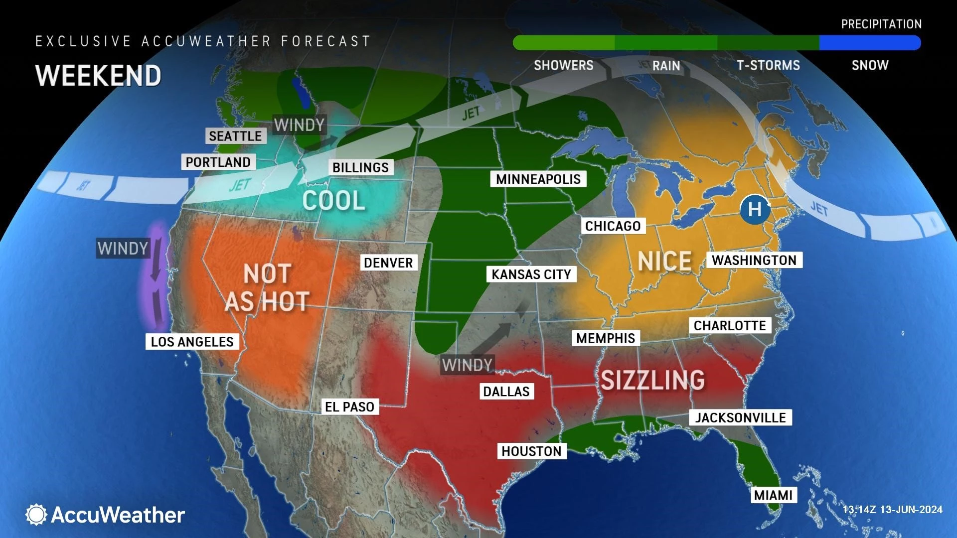
The Father's Day Weekend — also the last weekend of Spring, by the way — looks fantastic. Humidity goes away, the sun comes out, and both Saturday and Sunday stay completely dry.
And you think Friday is hot and steamy, just wait until next week. New Jersey is going to broil with anywhere from 5 to 9 days of 90+ degree temperatures. We might even hit 100 somewhere. With high humidity too. Air conditioners at the ready!

Friday
There are three things to talk about in Friday's forecast: Heat and humidity, poor air quality, and thunderstorms. Let's dive in.
Friday morning is beautiful. Hazy sunshine, with temperatures mainly in the 60s.
The vast majority of the day will be fair. Just hot and moderately humid. High temperatures are expected to reach about 90 degrees. A bit cooler at the Jersey Shore, thanks to a sea breeze. (Heads up for beach-goers: An elevated risk of rip currents is posted for today, likely to continue through the weekend.)
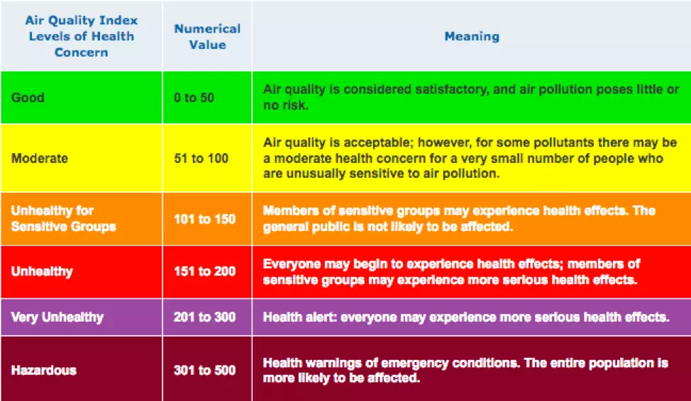
An Air Quality Alert - Code Orange has been issued for 13 New Jersey counties Friday. Basically along the NJ Turnpike corridor. When temperatures get this hot, the concentration of ground-level ozone increases. That can lead to breathing difficulties for the very young, the very old, and those with preexisting heart/lung issues. Air conditioning is definitely your friend on a day like this.
In this soupy air mass, there is realistically a chance of a popup shower or thunderstorm at any time. But realistically, our main storm chance holds off until the late afternoon and early evening hours. In other words, prime time for storms will be centered on the "dinnertime" hours.
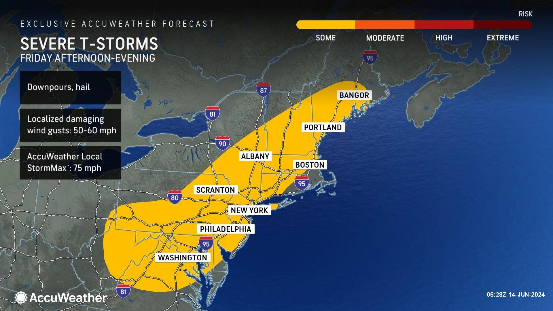
Initial thunderstorms will crash into northwestern New Jersey Friday afternoon, slowly drifting south and east through the evening hours. These storms will likely reach strong (40+ mph gusts) or severe (60+ mph gusts) limits, with heavy rain and lots of lightning too. Hail is possible. Generally, tornadoes are unlikely in "linear" storms like this — but it is still worth watching for that potential.
The bottom line: Keep an eye on the sky late-day Friday, and stay alert to changing weather conditions. When thunder roars, head indoors.
Skies should start to clear by Midnight Friday night, with rain ending completely well below daybreak Saturday. Overnight low temperatures will dip into the comfortable mid 60s.
Saturday
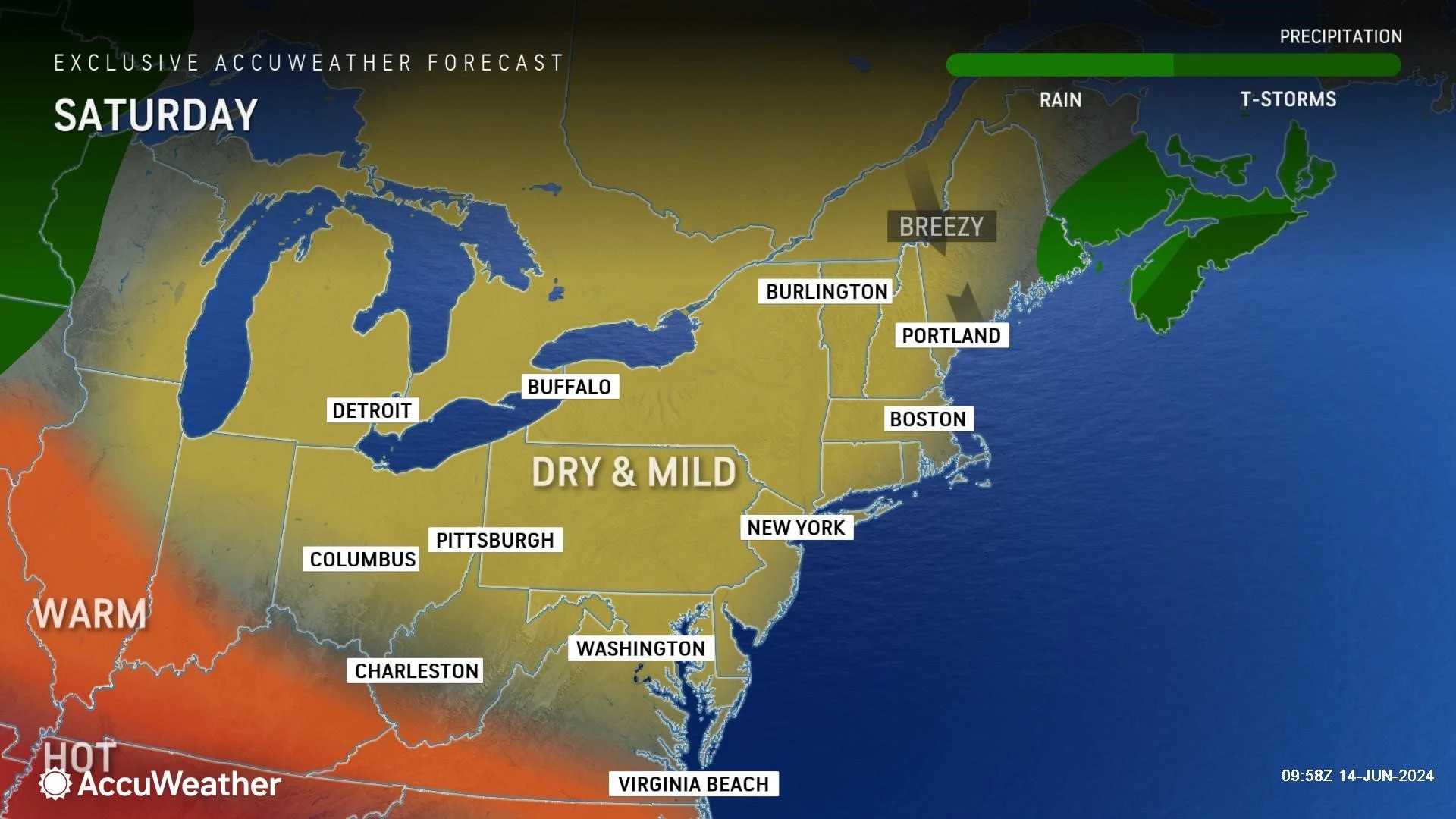
Humidity goes away, the sun comes out, weather conditions stay completely dry, and temperatures will be seasonably warm. What a fantastic June weekend!
As skies become sunny, high temperatures on Saturday should reach about 80 degrees. Dew points drop into the 50s (maybe even 40s), making the air much less humid and more comfortable. Light winds, dry weather. The only concern is the risk of rip currents and rough surf I mentioned above.
Sunday
Clouds will increase on Sunday, and it looks to be the cooler day of the weekend. But still, incredibly pleasant. (Especially compared to next week's impending heat wave.)
With a mix of clouds and sunshine, high temperatures will come down to about 75 to 80 degrees. Technically below normal for this time of year. But we will stay dry again — aside from drought concerns, you can't complain too much here.
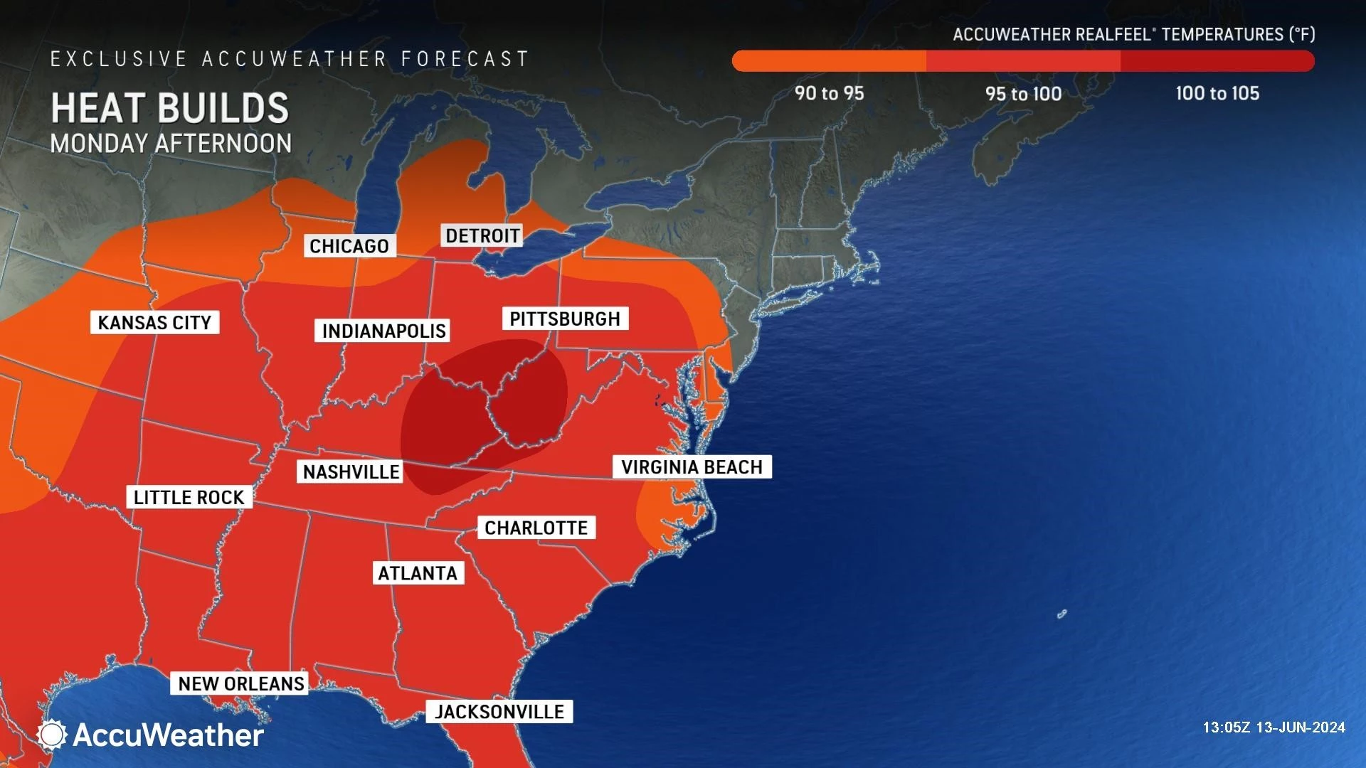
Monday
Monday will be a nice weather day, although noticeably warmer than this weekend.
Highs will shoot to around 85 to 90 degrees, similar to a typical midsummer day in New Jersey. It will be mostly sunny and dry. Dew points will probably creep into the 60s again, leading to an increase in that "muggy factor".
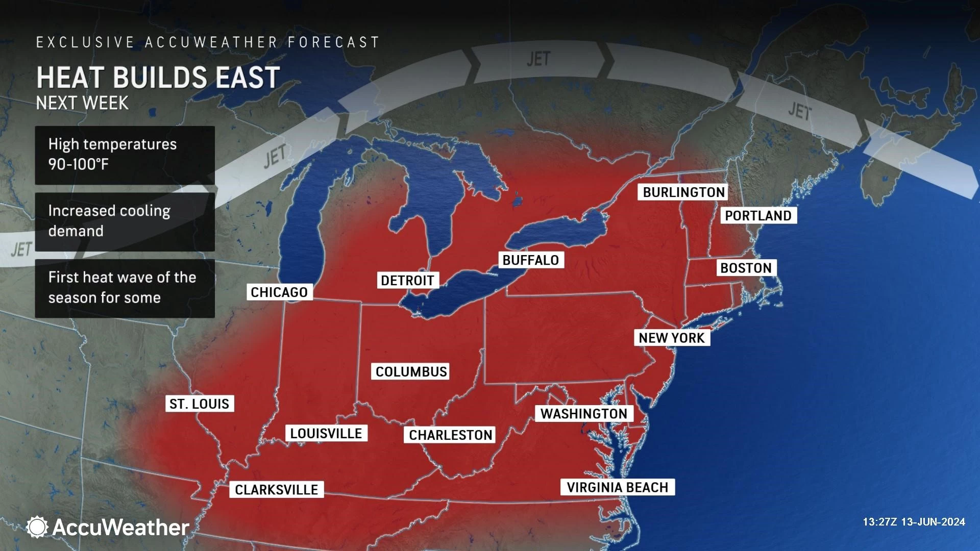
Tuesday & Beyond
Hot.
Widespread 90s will envelope New Jersey for Tuesday, Wednesday, Thursday, Friday, and Saturday ... at least!
The heat index ("feels like" or "apparent" temperature) may approach 100+ degrees on any given day, which is when we start talking about heat being "dangerous". Furthermore, any streak of three or more 90+ degree days is officially a "heat wave," suggesting potential ill effects on humans, animals, plants, and more. (Especially since low temperatures may not dip below 75 for a good portion of next week too.)
There are no organized storm systems to watch out for. But a popup thunderstorm will be possible any day during the heat wave, given our steamy atmosphere.
Different models have differing ideas of when and how the heat will break. Maybe next weekend. Maybe not until the final week of June.
In any case, the arrival of the Summer Solstice next Thursday is going to be sultry and summery. How appropriate.
Stay cool, have a great weekend, and Happy Father's Day to all!
BEEP BEEP BEEP: These are the 13 types of Wireless Emergency Alerts auto-pushed to your phone
Gallery Credit: Dan Zarrow
Dan Zarrow is Chief Meteorologist for Townsquare Media New Jersey. Follow him on Facebook for the latest forecast and realtime weather updates.
12 Perfect Movies to Watch on Father's Day
Gallery Credit: Bobby G.
More From New Jersey 101.5 FM


