

Severe T-Storm Watch: Warm weather ends with a bang Saturday
6:53 p.m. - UPDATE: All watches and warnings have been canceled as the squall line moves to the east of New Jersey.
Gusty winds, torrential downpours and dangerous lightning may arrive suddenly as strong thunderstorms march across the Garden State.
Background
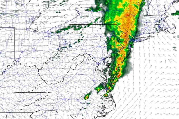
An approaching strong cold front will spawn a line of rain, which is expected to pass from west to east across the Garden State from Saturday late afternoon through evening.
Temperatures have once again spiked into the 70s across much of New Jersey Saturday afternoon. This very warm and humid atmosphere will provide plenty of "fuel" for those thunderstorms to become strong or severe.
Furthermore, these storms may arrive with little warning, so those outside enjoying the lovely Spring weather may encounter a nasty surprise.
Timeline
4 p.m. Saturday... Storms cross the Delaware River into western New Jersey.
6 p.m. Saturday... Storms reach the eastern edge of New Jersey, including the Jersey Shore.
9 p.m. Saturday... Storms and residual showers exit the state, with clearing skies shortly thereafter.
Watches and Warnings
The National Weather Service has issued a Severe Thunderstorm Watch until 8 p.m. for South Jersey: Atlantic, Burlington, Camden, Cape May, Gloucester, Salem, and Cumberland counties. A Severe Thunderstorm Watch has also been issued until 9 p.m. for the rest of the state: Bergen, Essex, Hunterdon, Mercer, Middlesex, Monmouth, Morris, Ocean, Passaic, Somerset, Sussex, Union, and Warren counties.
Remember that a watch serves as a "heads-up" for the possibility of hazardous weather. You should be prepared to take shelter if a warning is issued for your area.
Impacts and Action Steps
The biggest concern will be strong winds, both ahead and within the line of storms. 60+ mph wind gusts can easily do damage. It is also important to note these storms spawned several tornado warnings in eastern Pennsylvania.
Also, since many New Jerseyans have house and car windows open to enjoy Saturday's warmth and fresh breeze, the wind will be especially precarious.
Heavy rain is possible too. As is dangerous cloud-to-ground lightning. The bottom line here, as with any thunderstorm, is when the thunder roars, it's time to seek shelter in a sturdy building for the duration.
Behind the storms, a gusty wind will bring back the February chill. Sunday morning's low temperatures will bottom out in the 30s, with only 40s on thermometers by Sunday afternoon.
Dan Zarrow is Chief Meteorologist for Townsquare Media New Jersey. Follow him on Facebook or Twitter for the latest forecast and realtime weather updates.
More From New Jersey 101.5 FM


