
NJ weather: Some wintry mix and rain Monday, otherwise a quiet, mild week
The Bottom Line
There is only one hiccup in the weather forecast this week, and that is Monday. On the northern edge of a coastal storm system, two waves of light precipitation will sweep through New Jersey. The first, Monday morning, has already produced some snow and ice accumulations. The second, Monday night, will be primarily a rainmaker for New Jersey. You'll have to stay extra alert and watch for slick spots.
The rest of this week looks great. Warming temperatures and quiet weather are a nice treat at any point during the winter season. Our next opportunity for anything more active or significant would be next weekend.
Monday
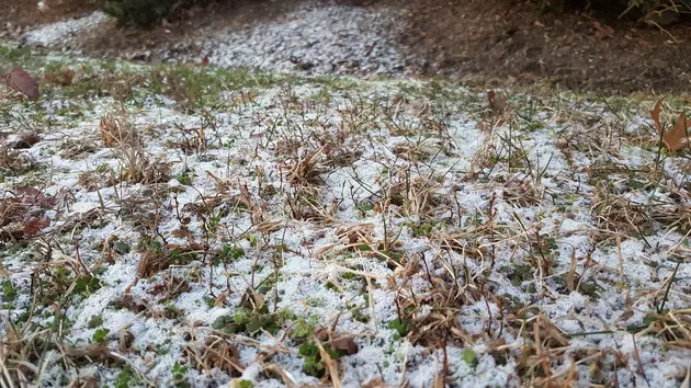
I have to admit, I was surprised how hot-and-heavy Monday's first round of precipitation arrives. (My early morning commute down Route 1 was shrouded in snow the whole way.) There are already some light snow accumulations, mainly on untreated surfaces along the Turnpike and Route 1 corridors. And some icy patches closer to the coast, around Monmouth, Ocean, and Burlington counties.
This band of light precipitation will continue drifting north throughout Monday morning. With temperatures right around the freezing mark, I have to put the catch-all "wintry mix" umbrella on the forecast. Exactly what falls from the sky will depend on the exact temperatures where you are.
Initial wintry mix should taper completely by around midday, give or take. As we enter a lull Monday afternoon, we'll carry mostly cloudy skies and chilly temperatures. Highs will only reach the mid to upper 30s.
The second and final round of precipitation from this storm system will arrive late afternoon, starting around 4 p.m. With temperatures in the 30s, this one is expected to be almost all rain. Having said that, I have two concerns:
1.) It may be cold enough in NW NJ (north of I-78, west of I-287) for a period of wintry mix or even straight snow overnight.
2.) The ground is pretty cold. So there could be some areas of freezing rain or freezing drizzle, where raindrops freeze on contact.
Again, not a major storm, not a bread-and-milk situation. Just watch for slippery spots late Monday night. I expect all precipitation and wintry impacts to wrap up by Tuesday morning's commute.
Tuesday
Finally, we catch a break of quieter weather. Skies should clear by sunrise Tuesday, with some fair weather clouds dotting the sky throughout the day. It will be breezy, blowing out of the west up to 20 mph. But that won't be a chilly breeze, necessarily. HIgh temperatures will push to the seasonable lower to (maybe) mid 40s. A nice early February day.
Wednesday
The warming trend continues, as winds become southwesterly and skies go sunny. Highs will come close to 50 degrees on Wednesday afternoon. Definitely closer to "jacket weather" than "heavy coat conditions".
Thursday
Thursday will feature more clouds and a stronger west wind. But I see no reason why temperatures would be much different than Wednesday. Again, we'll top out close to 50 degrees.
Friday & Beyond
A weak intrusion of cooler air will push Friday's temperatures downward. But it's not an arctic blast — it's just a return to near-normal levels. Highs return to the lower-mid 40s as sunshine returns overhead.
Saturday will probably be the warmest day of the week, potentially pushing into the mid 50s in South Jersey. Skies will become increasingly unsettled though, becoming mostly cloudy and with a stiff southwest breeze.
Finally, we're always watching the horizon for the next opportunity for a storm. And the past few model runs have hinted at "something" at the tail-end of next weekend, heading into Valentine's Day. The latest guidance is actually mixed on a "miss" (GFS) versus a "hit" of snow (Euro). With about 6 days (144 hours) to go until first flakes, a coin flip or dartboard would perform about as good as models right now. So we'll sit and wait. If that storm system turns into a big deal for NJ, we'll start talking seriously about scenarios around Wednesday or Thursday. Not before.
Dan Zarrow is Chief Meteorologist for Townsquare Media New Jersey. Follow him on Facebook or Twitter for the latest forecast and realtime weather updates.
LOOK: 20 Fascinating Photos From the First Modern Olympic Games in 1896
Gallery Credit: Caitlin PenzeyMoog
Where everyone knows your name: Friendliest bars in NJ
Gallery Credit: Jordan Jansson
More From New Jersey 101.5 FM


