

NJ weather: Another shot at showers Wednesday into Thursday
The Bottom Line
Here is some welcome news: Each of the next four days (at least) has a rain chance plugged into the forecast for New Jersey.
However, let's once again keep our expectations in check. That rain looks to be scattered and light — no soakings, no flooding, no severe weather threats. This is not the drought-buster we are looking for.
There are actually two mechanisms conspiring to keep New Jersey's weather unsettled and dreary through the upcoming first weekend of fall:
1.) A warm front, Wednesday to Thursday, pushing through a couple rounds of rain.
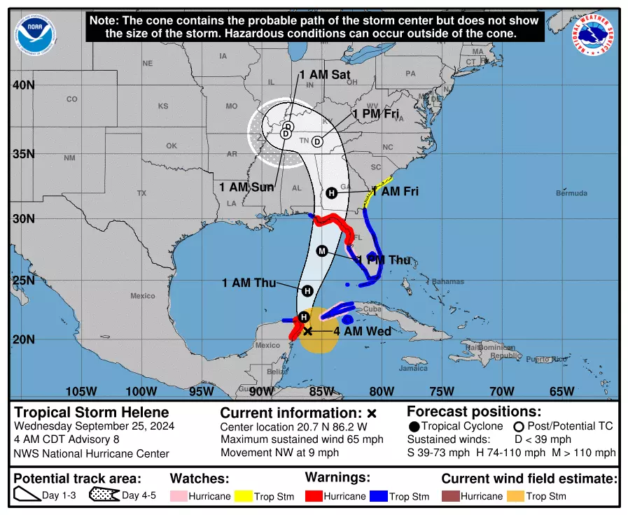
2.) Tropical Storm (soon to be hurricane) Helene, which could clip southern NJ Friday into Saturday.
Just to be crystal clear, New Jersey is not going to see a "direct hit" from Helene. Florida's Gulf Coast will get smacked hard. The southeastern U.S. will get soaked. But here? Just clouds and some showers.
If we get a quarter-inch of rain by the end of the week, I will be impressed. That will still keep us in the running for one of the driest Septembers on record.
Meanwhile, temperatures are going to jump around a bit, as we taste a one-day warmup followed by more seasonable conditions.
Let's dive into the specific timeline so you know exactly what to expect, and can plan your week accordingly.

Wednesday
Wednesday is starting off dry and comfortable. Temperatures are averaging lower 60s across the state, with a blanket of clouds and a light breeze.
We'll keep the clouds and the relatively cool temperatures, as highs only reach the upper 60s to around 70 degrees once again. So similar to Tuesday, but with a drearier sky.
In addition, one or two rounds of rain look likely Wednesday. The first will push in from late morning through the afternoon, primarily impacting the western and northern edges of the state. (Having said that, I do think everyone in New Jersey will see a shower at some point.)

Another batch of showers is likely to arrive Wednesday night. Maybe a rumble of thunder. But in terms of rain, it is still just scattered light stuff.
One more note for the Jersey Shore: The ocean and bays are finally calming down. A Coastal Flood Advisory for Ocean County's back bays is set to expire Wednesday evening, after two more rounds of minor category flooding. A high risk of dangerous rip currents should decrease to moderate on Thursday.
Thursday
First of all, you will notice how humid and warm it gets Thursday. High temperatures will reach for about 75 to 80 degrees — swinging back to above-normal for late September. And a dew point of 70 will make the air feel extra sticky and steamy.

A few spot showers and even a thunderstorm are possible throughout the daytime hours on Thursday. They will be very sporadic and isolated.
Skies on Thursday will probably be brighter than Wednesday, in general. It will still be mostly cloudy. A bit breezy too.
Friday
Earlier in the week, I was thinking Friday would mark our flip back to bone-dry, perfectly-pleasant weather. But now Helene throws a wrench into those works, as we end up on the northeast edge of the storm's remnants.
At the very least, we are going to keep clouds in place on Friday. I am waffling between calling it "mostly cloudy" and "overcast" — you get the picture.
In addition, some showers may stream through southern New Jersey. Given the latest forecast, I doubt we would see rain cross north of Interstate 195. And rain looks scattered to broken, and generally light. Again, Helene's moisture-rich center will stay far away from NJ.

Because of the clouds and raindrops, high temperatures on Friday will retreat to the lower 70s. Not awful, but dreary at times. At least it will be less humid, as the dew point drops to about 60 — still a touch of stickiness to the south.
Saturday
Saturday is a tricky call, as we may still have some Helene showers in the neighborhood of South Jersey.
I will be optimistic and say that any sporadic raindrops there will be limited to the morning hours. Then skies will brighten a little, with peaks of sun.
Temperatures throughout this weekend will be at or just below seasonal normals. Saturday should top out around 70 degrees.
Sunday & Beyond
Sunday looks like the better weekend day overall. Skies become partly sunny, and temps nudge into the lower 70s.
The big weather driver next week is forecast to be a strong cold front, arriving in the Tuesday-Wednesday time frame. In essence, that is the one that will push out all the "junk" weather in our atmosphere. It will push in another batch of rain. And an influx of cooler, drier air. (FYI, October begins on Tuesday.)
By late next week, overnights might start getting cold enough for widespread frost in New Jersey's northwest hills. That is about right — the vast majority of New Jersey experiences the first frost of the season in October.
These 11 NJ schools are Blue Ribbon winners this year
Gallery Credit: Erin Vogt
Dan Zarrow is Chief Meteorologist for Townsquare Media New Jersey. Follow him on Facebook for the latest forecast and realtime weather updates.
Worst 30 public schools in New Jersey
Gallery Credit: Rick Rickman
More From New Jersey 101.5 FM


