

Next five days: Mix of warm and cool, wet and dry weather for NJ
The Bottom Line
Unsettled weather is complicated weather. With a broad area of low pressure sitting over Canada and a frontal boundary expected to stall directly over New Jersey in the coming days, it becomes very difficult to pinpoint exactly when it is going to rain and when it is not. As always, I will do my best here — just try to "blur your eyes" when reading the forecast through early next week, and keep an umbrella handy.
Unsettled weather will break on Tuesday next week. Until then, there will be pockets of showers alongside breaks of dry weather. Meanwhile, temperatures will swing between well-above and well-below normal — there is no "in between" here. The warm days will be Thursday, Friday, and Sunday. Everything else is trending cool.

Thursday
Thursday will be a classic warm front day. Starting with dampness and cloudiness. And ending with a big surge of warmth and humidity.
We have had some drizzle and mist overnight, making for a damp and dreary start to the day. There is a batch of thunderstorms charging across New Jersey too. Forecast models suggest they will largely disintegrate before reaching New Jersey — but because that is not a guarantee, I have to keep spotty showers in the forecast through the morning hours.
Temperatures are starting out between 40 degrees (north) and 60 degrees (south). Despite thick cloud cover and those occasional raindrops, most of the state should rise into the 70s Thursday afternoon. That is about 25 degrees warmer than Wednesday, and well above normal for early April.
It will be breezy. And with dew points climbing well into the 60s, expect noticeable humidity through the afternoon and evening hours too.
As a cold front arrives Thursday night, scattered rain showers will return. Starting around 10 p.m. Because our atmosphere will be "juicy" and unstable, there is a risk for a strong thunderstorm to set up. A localized pocket of heavy rain and/or gusty winds is possible. But the timing and dynamics are not perfect here — so I do not think we will see anything too crazy. Just stay alert to changing weather conditions, as always.
Friday
The overnight showers will probably linger over parts of New Jersey until about midday Friday. Then hopefully, we will squeeze out a dry afternoon and early evening.
I will even call Friday "mostly cloudy," potentially allowing for some glimmers of sun.
We will be in a slightly cooler air mass Friday, so high temperatures will descend to the 60s. Still above normal for this time of year.
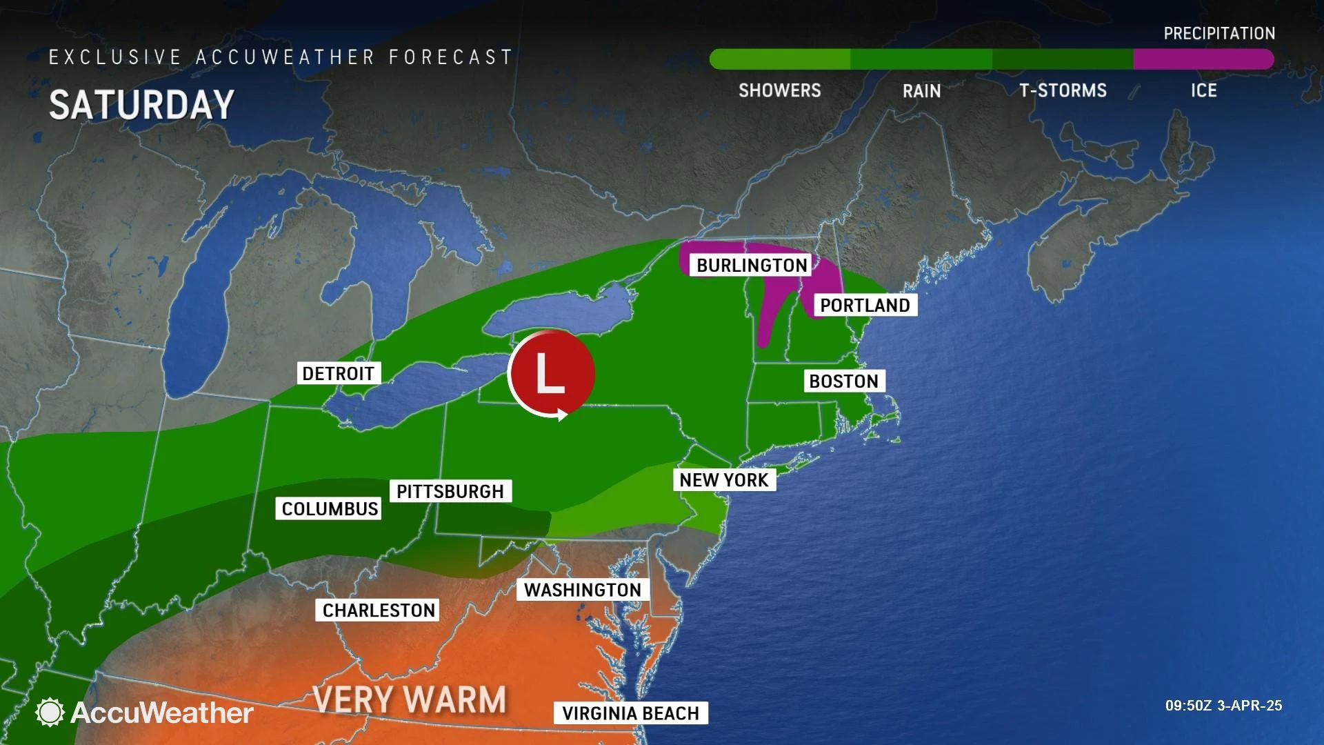
Saturday
Saturday will be particularly cool and dreary. And guess what, more raindrops are possible to kick off the first weekend of April.
I think the best chance of rain on Saturday will be early and late. But that does not mean the middle of the day will be pleasant. Expect gray skies and high temperatures only around 50 degrees. A breeze blowing off the ocean will keep Shore towns particularly chilly.
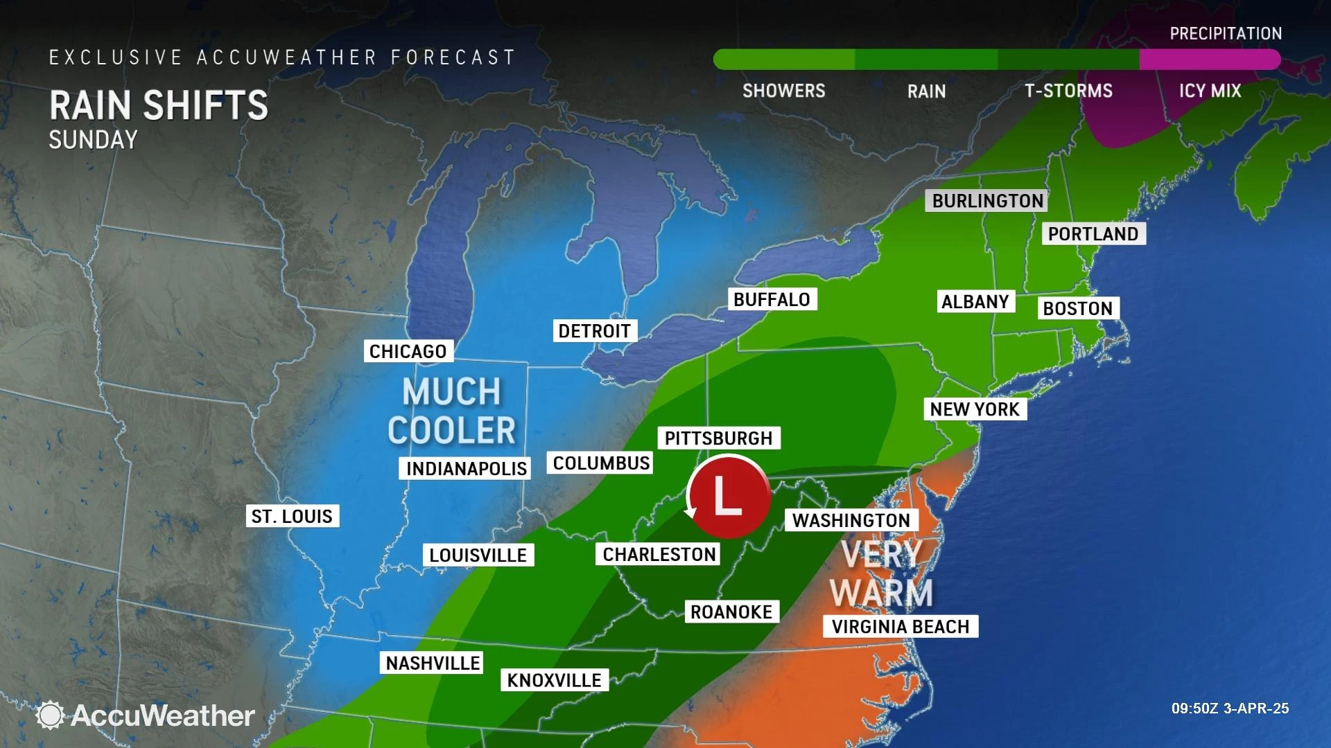
Sunday
Sunday is tricky. Most model guidance is pointing to another surge of warmth, away from northern and coastal New Jersey. Mainly in the 70s. Possibly as hot as 80 degrees.
But again, it will be hard to enjoy the warmth and/or outdoor activities. Rain chances ramp up again by Sunday afternoon, most likely resulting in showers and thunderstorms to end the weekend.
Monday
Monday will be a grand transition day for New Jersey. In previous forecasts, I had declared the day to be dry. But now it looks like a few showers are possible, both early and late.
Monday will be mostly cloudy — again, I am using that description to suggest a peek or two of sun is possible. And much cooler again, with highs only around 50 degrees.
The Extended Forecast
The middle of next week is trending dry but cool.
Tuesday's high temperatures are forecast to only reach the upper 40s. With a brisk wind, that is going to be an uncomfortable chill for early to mid April.
Wednesday will be the bottom of the barrel, with a widespread late-season freeze possible in the morning. Highs will again only average upper 40s in the afternoon, with a brisk wind.
Temperatures should moderate into late next week. Our next storm system will probably bring soaking rain to New Jersey sometime around next weekend. (For the record, I would much rather have a short drenching than a 5-day period of hit-or-miss showers!)
Play ball NJ: New Jersey baseball pros to watch in the MLB
Gallery Credit: Erin Vogt
Dan Zarrow is Chief Meteorologist for Townsquare Media New Jersey. Follow him on Facebook for the latest forecast and realtime weather updates.
Weird things NJ taxes - and some they don't
Gallery Credit: Eric Scott
More From New Jersey 101.5 FM


