

Minor-moderate tidal flooding still an issue for the Jersey Shore
The Calm After the Storm
Well, it certainly looks and sounds a lot calmer outside on this Saturday morning. Aside from a few stray snowflakes, precipitation from our nor'easter has come to an end. The 60+ mph wind gusts are long gone. Still lots of cleanup to come though, with downed trees and numerous power outages across the entire Garden State. And the threat for coastal flooding continues, as it does any time there is a powerful storm system in the Atlantic basin.
Not a single forecast model "nailed" this storm (and not a single meteorologist either). We had the major theme correct (i.e. "a nasty day"), but temperature and precipitation type presented tremendous challenges (we knew they would). The constant flip-flopping of temperatures above and below the freezing mark, leading to some surprise snow accumulation in central New Jersey (in places like Freehold and Brick) and South Jersey (around Hammonton).
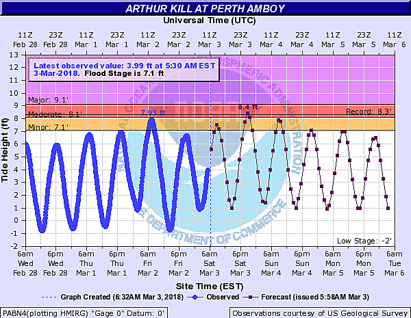
Coastal Flooding Picture
Friday evening's high tide cycle was actually a half-foot to a foot lower than expected. I suspect the brisk northwesterly wind helped to counteract the surge and wave action being spit out by the nor'easter. The lower tide peak was certainly good news for coastal communities, although there were still some very large puddles in particularly vulnerable areas such as Long Beach Island.
Bottom line... The latest guidance suggests the next three high tide cycles (Saturday morning, Saturday evening, and Sunday morning) could cause minor to moderate flooding along the Jersey Shore.
"Minor" flooding usually means vulnerable roadways will become unappeasable due to water inundation. "Moderate" flooding is a bit more serious, and could lead to some property damage along tidal waterways. Honestly, there's nothing much to do at this point but hold our collective breath and use common sense if you do encounter flooded areas.
The Extended Forecast
Saturday will remain mostly cloudy and blustery, with occasional wind gusts over 30 mph (especially along the coast). We'll see seasonable high temperatures in the lower to mid 40s.
Skies should clear a bit Saturday night, and Sunday should feature a more pleasant mix of sun and clouds. Our weather forecast looks fairly quiet and fairly typical for early March through Monday and Tuesday too.
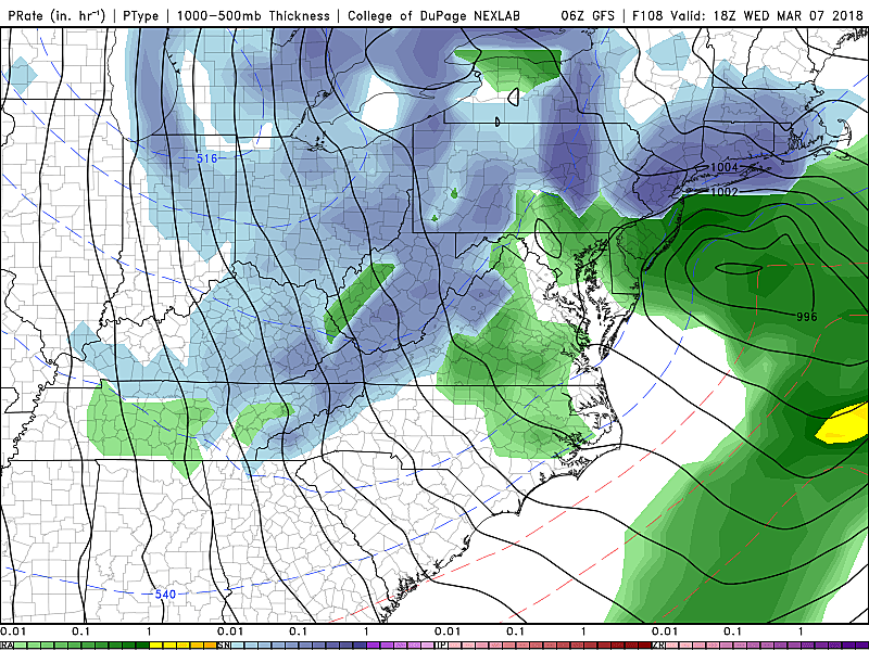
The next storm system worth watching will be in the Wednesday-Thursday time frame. The GFS model paints a rain to snow event, with some significant accumulations possible by Thursday morning. The Euro shows a less-organized system, with a couple of inches of fresh snow at the most. Honestly, the way this season has gone, we won't have a great handle on the details until a day or two before. But again, worth watching for sure.
Ha, and you thought Winter was over???
Dan Zarrow is Chief Meteorologist for Townsquare Media New Jersey. Follow him on Facebook or Twitter for the latest forecast and realtime weather updates.
More From New Jersey 101.5 FM


