

Cold air grips NJ, with one chance of snow coming up this week
The Bottom Line
Happy Cyber Monday! And welcome to the first weekday of December. This is, on average, New Jersey's 3rd coldest and 3rd snowiest calendar month. And curiously, it is our 4th wettest month of the year too — while we do not think of December as a particularly rainy month, I think that stat points to the volatility of late fall and early winter weather.
Speaking of volatile, you are in for a rude wakeup to start the week, with a very cold and very dry air mass firmly in control of New Jersey's atmosphere. That will yield temperatures holding about 10 degrees below normal. Feeling much more like the middle of winter (late January) than early December.
The other story of the week is a storm system set to clip New Jersey late Wednesday night into early Thursday morning. There could be some snowflakes — and raindrops — around New Jersey. Nothing big, but light accumulations and slippery spots are possible. Wind is a concern for Thursday too.
Grab the heavy winter coat, a mug of hot cocoa, and settle in for an unseasonably wintry forecast.

Monday
Back to work, back to school. Bundle up!
As of this writing (6 a.m.), temperatures range from 11 to 32 degrees. The entire state is at or below the freezing mark. By the numbers, this is New Jersey's coldest morning since late February.
High temperatures Monday afternoon will only reach the upper 30s for most of the state. Maybe touching 40 degrees along the southern coast. Overall, that is similar to Sunday. And again, well below seasonal norms. Don't be afraid to reach for the heavy winter gear — coat, hat, gloves, etc.

Monday will feature lots of sun, with a few clouds through the afternoon. Heavy lake-effect snow has dumped feet of snow on parts of western and northern New York State. Remnants of those snow bands will try to drift toward New Jersey — the end result would be a flurry, if anything.
Monday night will be clear and cold. Low temperatures will once again average mid 20s — firmly back in "brrr" territory.
Tuesday
Tuesday will be a similarly quiet, unseasonably chilly day.
Under mostly sunny skies, high temperatures will only reach about 40 degrees. At least the wind stays light and weather stays dry.

Wednesday
The daytime hours on Wednesday will be fine, although still on the cold side. Our next storm system holds off until late Wednesday night. (Which I will cover in the Thursday section below.)
Clouds will increase on Wednesday, first in the form of high, thin clouds. So it should still be a fairly bright sky overall. Thicker overcast conditions are likely later on, as our clipper storm system approaches.
A stiff breeze will kick up by Wednesday evening too, potentially gusting to 20 mph.
Temperatures will rise into the lower 40s Wednesday afternoon. And thermometers will stay there through Wednesday night and Thursday morning. (An important factor for our impending storm system, of course.)
Thursday
Although not particularly strong, moisture-rich, or well-organized, a clipper storm system is expected to arrive in New Jersey by early Thursday morning. And it will produce some potentially impactful weather — showers and wind.
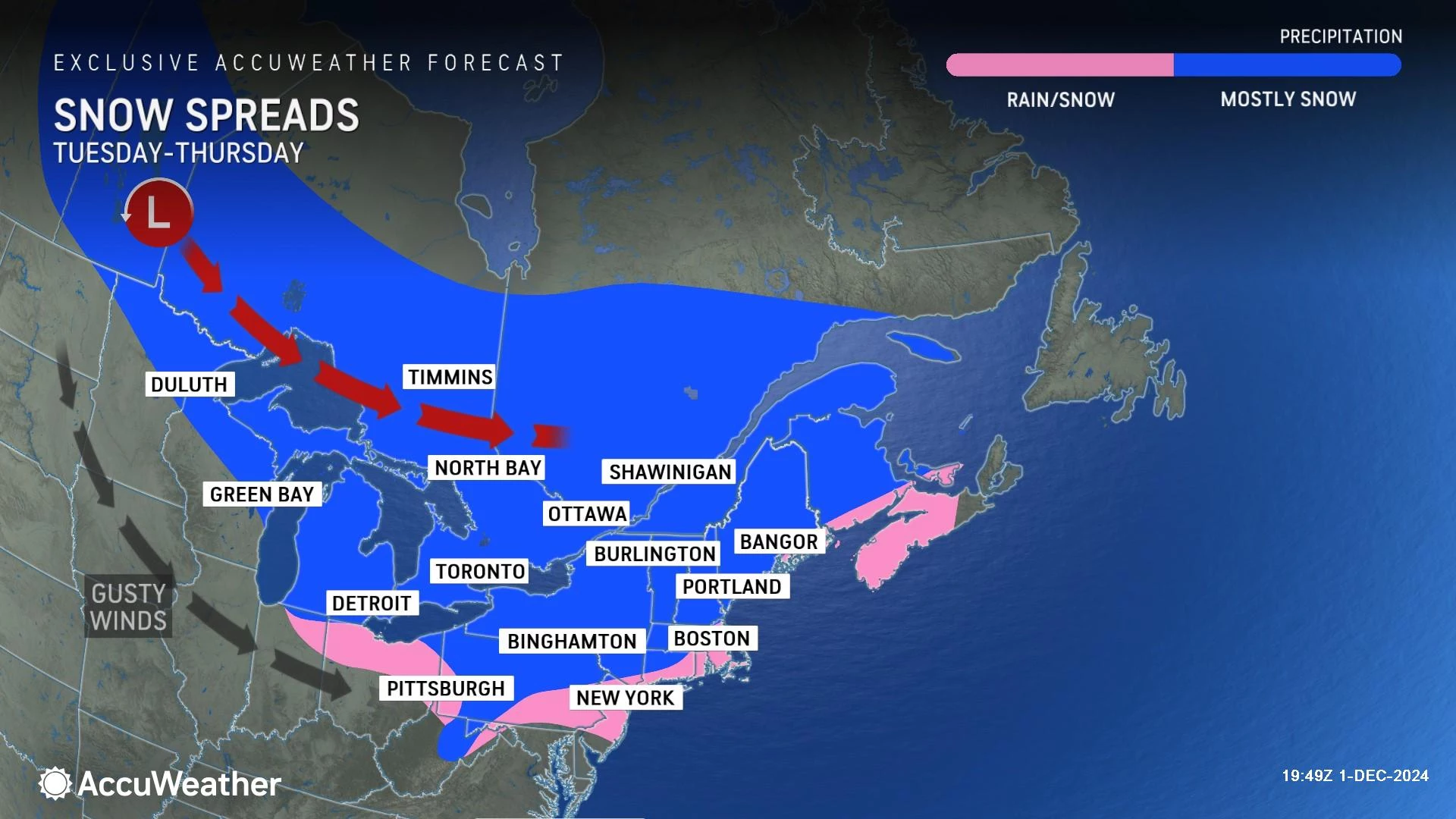
First, let's talk about precipitation. Between about 9 p.m. Wednesday and 9 a.m. Thursday, scattered showers will push from west to east across New Jersey. Generally light and brief, although precipitation may become steady for a time between Midnight and daybreak.
I suspect snow and/or wintry mix will be the predominant precipitation type for most of New Jersey. Away from warmer urban and coastal areas, at least. And that does raise eyebrows for slippery spots and even light accumulations through Thursday morning's rush hour.
On the high side, I will say we could see an inch of snow accumulation in spots. Which still is not much — but especially since it would potentially be the first snowfall of the year for much of the state, the chance comes with some extra attention.

By mid-morning Thursday, skies will start to clear and our precipitation chances will be over. The rest of the day will be blustery though, with northwesterly wind gusts potentially reaching 40 mph. That is strong enough to bring down weak tree branches, cause sporadic power outages, and force flight delays. It is also going to feel quite cold, as temperatures descend from the 40s deep into the 30s by the late afternoon.

Friday & Beyond
Friday could be the coldest day of the week, especially from a "wind chill" or "feels like" perspective. My latest forecast puts highs only in the mid 30s. With a stiff breeze, potentially keeping the wind chill only in the 20s all day. It will be mostly sunny and dry.
Temperatures should moderate through the first full weekend of December, into the 40s. Some model guidance hints at a storm system passing just south of New Jersey. It may be close enough to clip NJ with a shower, so it is worth watching.
Next week should start mild, potentially in the 50s. And then another storm system midweek will probably kick up some rain, wind, and initiate another big cooldown. As a whole, the entire first half of December should trend below seasonal normals.
There are no significant snow storm chances on the horizon, but we are always watching this time of year.
10 of New Jersey's best holiday pop-up bars
Gallery Credit: Jill Croce
Dan Zarrow is Chief Meteorologist for Townsquare Media New Jersey. Follow him on Facebook for the latest forecast and realtime weather updates.
NJ's top 10 downtowns with the most holiday spirit
Gallery Credit: Jill Croce
More From New Jersey 101.5 FM


