Cloudy, cool, breezy, wet: A mixed bag of ‘yuck’ for NJ this week
Whenever a storm system stalls, gets blocked, or otherwise ends up stuck, it leads to an extended period of yucky weather. That's exactly the story of New Jersey's weather forecast this week, as a coastal storm meanders just to our east. If you're looking for a "beautiful" day, unfortunately you're going to have to wait until Monday.
The effects of Monday night's cold front were actually wetter than I anticipated — much of northern New Jersey picked up over a half-inch of rain. Roads are damp on this Tuesday morning, and radar is still showing some pockets of rain. Therefore, I have to keep lingering showers in the forecast for at least the first half of Tuesday. Hopefully things will dry out a bit by Tuesday evening.
It will be cloudy and cooler than Monday, which topped out at a humid 80 degrees. Tuesday afternoon's highs will be limited to the upper 60s. Near-normal for early October. And for the record, this will be the warmest day through the rest of the week.
Tuesday night looks generally dry, but I'd be foolish not to include an isolated shower chance. Low temps will dip into the mid 50s by Wednesday morning.
And then things get 'yuckier' for New Jersey. A pretty strong storm system centered about 200 miles east of the U.S. East Coast will slowly meander in the neighborhood from Wednesday through Saturday. In most cases, a coastal storm like this will just shoot out to sea, succumbing to the ambient "Westerlies" wind circulation. But there is a large area of high pressure in the middle of the Atlantic Ocean. This giant dome of sinking air will "block" the coastal low from ejecting out to sea.
So our powerful coastal storm will just sit. And spin. And drive rain, wind, and water toward the coast.
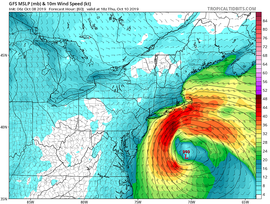
Wednesday looks like the wettest day through the rest of the week. The NAM and GFS models paint a "scattered showers" scenario over New Jersey. The Euro notably puts the storm system closer to the coast, which would lend to a steadier "periods of rain" solution. Once again, you won't see much (if any) sunshine. And high temperatures will end up well below seasonal norms, in the upper 50s to around 60 degrees.
In addition, winds are expected to kick up from that coastal storm system. Gusts will potentially top 30 mph along the Jersey Shore, blowing out of the northeast. (Yes, you can call this storm system a nor'easter if you really want. I've opted to not — too dramatic.)
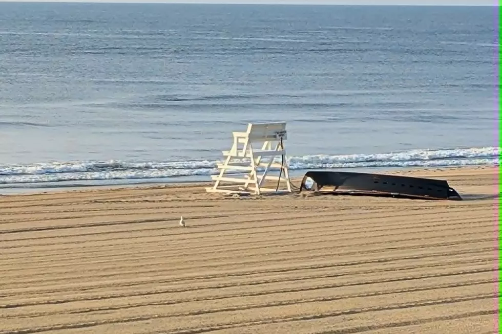
So we're in for breezy to blustery conditions through the rest of the week. More importantly, that wind will push quite a bit of ocean water to the coast. This is a rising concern that should not be ignored, even though this coastal storm system will not make a direct impact on New Jersey.
The latest surge models show increasing tidal water levels over the next 7+ high tide cycles. Up to 1 foot of surge on Tuesday could produce minor flooding in especially vulnerable spots along the Shore. 1 to 2 feet of surge on Wednesday is enough to produce minor to moderate flooding at high tide. And on Thursday, water levels could reach 2 to 3 feet higher than normal, enough to produce widespread moderate flooding. These models only predict water levels 72 hours in advance, but I suspect we'll be dealing with high water through Friday and Saturday too.
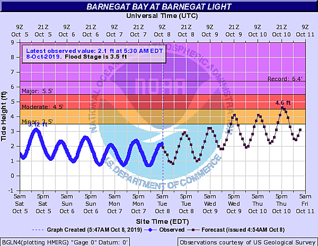
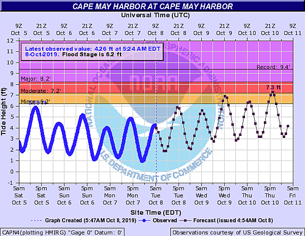
Remember that coastal flooding is highly dependent on the precise wind direction. And it is cumulative. If back bays don't have an opportunity to adequately drain between high tides, we have a higher starting point for the next cycle. Could lead to bad news, in the form of road closures and even some property damage. (No warnings or advisories are in effect, as of this writing.)
On Thursday, our rain chance scales back to the coast only. Hey, western New Jersey could even see peeks of sun. It will remain breezy and cooler, with high temps only in the lower 60s at best.
Another batch of rain is expected Friday with a continuing on-shore wind. Highs again near 60.
Weather conditions will improve this weekend, as that pesky coastal storm finally ejects out to sea. But there's still a chance for some rain too. I don't want to get into exact details yet, as this forecast is very low confidence at this time frame. Let's see how things play out over the next couple of days, and then we'll help you make more concrete weekend plans.
Even though the coastal flooding situation is becoming more precarious, I am not initiating around-the-clock coverage just yet. Next weather blog update is expected around 6 a.m. Wednesday morning.
Dan Zarrow is Chief Meteorologist for Townsquare Media New Jersey. Follow him on Facebook or Twitter for the latest forecast and realtime weather updates.
More From New Jersey 101.5 FM