The heat is on: Could New Jersey hit 100° this week?
The Bottom Line
The last few weeks of weather have been amazing. Far more pleasant days than not, with comfortable humidity levels and generally seasonable temperatures. Early June can be one of the nicest periods of the entire year, and this one certainly delivered.
Aaaaaaand ... it's all over now.
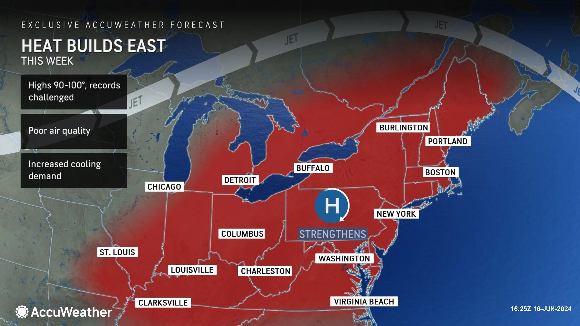
A prominent heat ridge will build into the Northeast United States this week. That means we have an extended stretch of unseasonably, uncomfortably hot temperatures ahead. Just in time for the start of Summer, coming up on Thursday.
Could we break records this week? Maybe.
Could we hit 100 degrees at some point? Possibly, especially late-week.
Is this heat wave potentially dangerous? The temperature and heat index will be close to the "danger zone" — you definitely have to take care of yourself in such conditions.
Will this heat wave qualify as historic, catastrophic, biblical, etc? Doubtful.

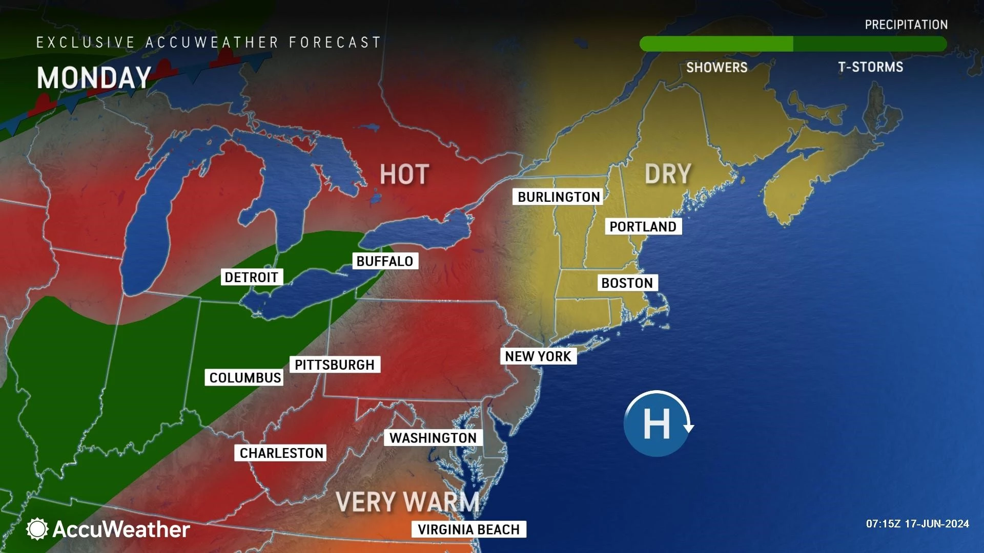
Monday: Regular Summertime Heat
A "typical" midsummer day in New Jersey has morning lows near 70 and afternoon highs around the mid 80s. And that is exactly where we will end up Monday. Definitely warm. Especially by mid June standards. But nothing crazy yet.
Expect mostly to partly sunny skies, a noticeable southerly breeze, and completely dry weather Monday. High temperatures are forecast to reach the mid to upper 80s. That is 5 to 10 degrees warmer than Sunday, and 5 to 10 degrees above normal for this time of year.
Could we hit 90 degrees somewhere in the state Monday? Absolutely. Inland South Jersey would be the most likely candidate. Possibly the NYC metro area too. And then our "Jersey heat wave" is on.
Hopefully we will catch a nice sea breeze Monday, keeping Jersey Shore beaches considerably cooler. Barrier islands could end up in the 70s for much of this week's scorch-fest.
As for humidity? It will be there. We use the dew point temperature, a measure of moisture (water vapor) in the atmosphere, as our ultimate "muggy meter". It not only describes how comfortable and "breathable" hot air might be, but also how efficiently the human body can use the evaporation of sweat as a cooling process.
A dew point in the 40s is dry. 50s is comfortable. 60s is sticky. 70s is steamy and 75+ is tropical.
Monday's dew point will creep upward to just above 60 — right on the edge of stickiness. Of course, it will be very warm. Definitely a sweaty day.
One of the worst aspects of a heat wave is when the hot daytime temperatures and high humidity do not allow for thermometers to drop below 70 degrees overnight. We need that "nighttime reset" for infrastructure, utilities, animals, and plants to rest and refresh.
The good news is that most spots should drop into the 60s Monday night to early Tuesday morning. The exceptions apply: urban and coastal areas will stay a bit warmer.
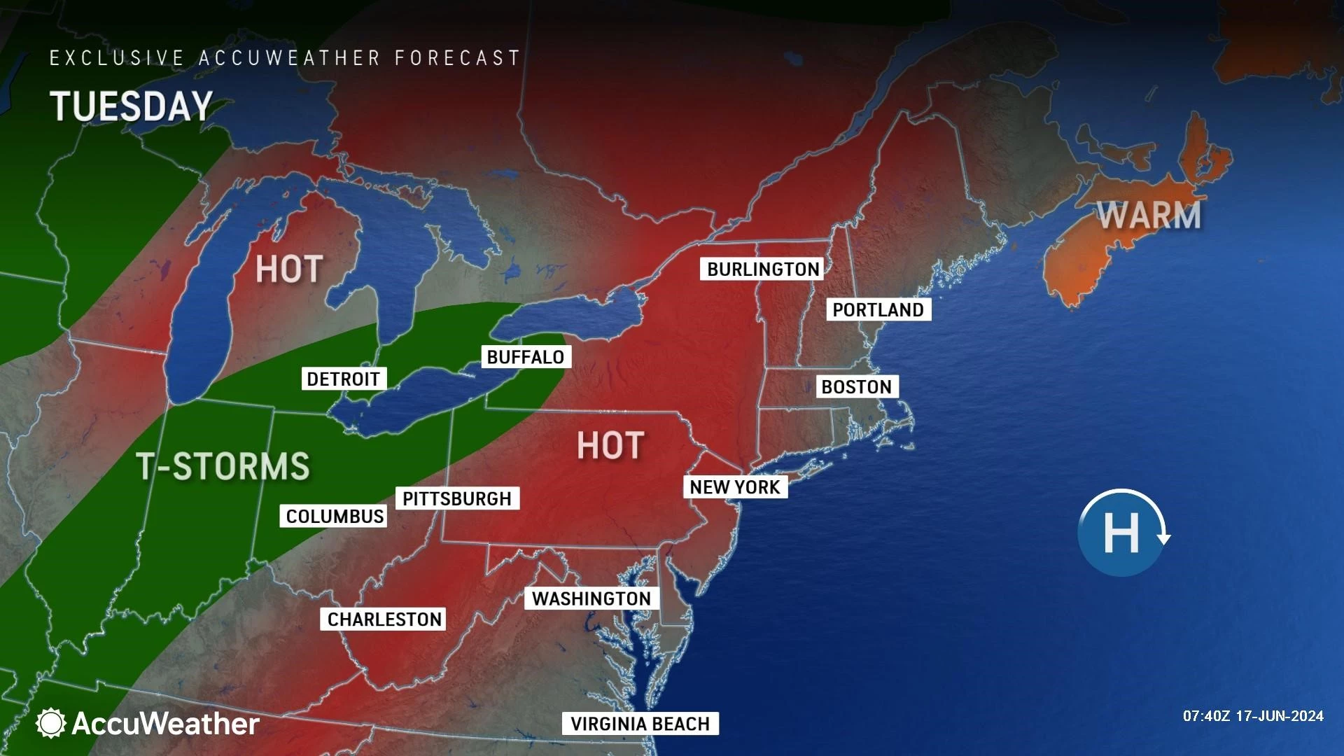
Tuesday: Heat Advisory
On Tuesday, the heat kicks up another notch. High temperatures will bump into the lower 90s for most of the state. (Away from the coast, at least.)
Meanwhile, the dew point will rise to about 65. The air will feel thick, but not quite tropical and suffocating. The good news: This is about as high as the dew point will get through the rest of the week.
When you combine the effects of heat and humidity, you get the "heat index". It is not only a "feels like temperature" for hot days — it is a direct estimate of human health impacts of such sweltering weather.
On Tuesday, the heat index may approach 100 degrees. And that is the trigger for a Heat Advisory to be issued by the National Weather Service. That is in effect starting late Tuesday morning for 18 of New Jersey's 21 counties — the only exceptions are Atlantic, Cape May, and Cumberland. (Both due to the cooling marine influences and because they have a higher heat index threshold for heat advisories.)
How Hot Will It Get?
In the words of my esteemed colleague Big Joe Henry, "It's gonna be Congo hot!"
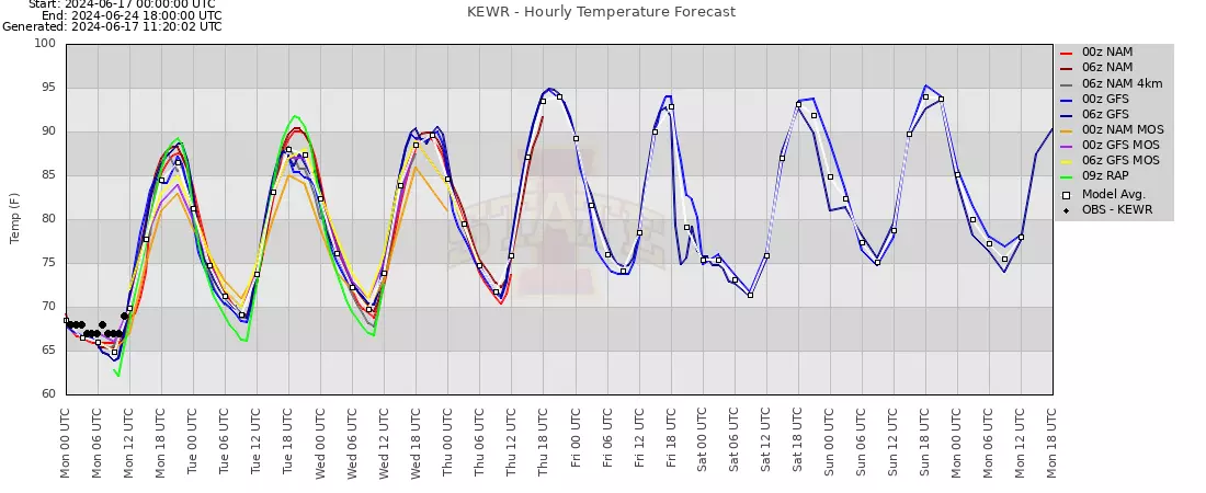
The latest model guidance suggested widespread mid 90s are a possibility for Wednesday, Thursday, Friday, and the weekend. In other words, the later in the week it gets, the hotter it will get. An Excessive Heat Watch is in place for most of the state from Wednesday through Saturday — that will be upgraded to a warning, as long as the forecast holds.
Record high temperatures may be in jeopardy along the way. Keep in mind, it is still early in the season — those historical record highs are not as "extreme" as they are in July and August.
We could also hit the "magical" triple digit mark, 100 degrees, at some point too. Forecast models have flip-flopped whether such intense heat will build over New Jersey's interior or not. Best chance would be in the Thursday-Friday-Saturday time frame.
Just in case you're wondering, here is a list of the last time our local climate reporting stations hit 100 degrees:
—Newark Liberty International Airport... August 9, 2022
—Trenton Mercer Regional Airport... July 18, 2012
—Atlantic City International Airport... July 21, 2019
—Central Park, New York City... July 18, 2012
—Philadelphia International Airport... July 18, 2012
That would mark a pretty significant heat event at TTN, NYC, and PHL, as it has been almost 12 years since topping the century-mark. It is also important to note that 100s in June have happened in NJ, but they are relatively rare.
Any Relief?
There are some saving graces here:
1.) Humidity levels will stay moderate, out of the truly "tropical" 75+ range.
2.) I am hoping that will keep the heat index generally below the danger zone.
3.) We will hopefully get that "nighttime reset" with most temperatures dropping below 70.
4.) You will find great relief at the Jersey Shore — as long as the weather stays dry and the sea breeze is cool enough, beaches and boardwalks will be hoppin' for the first weekend of summer.
Any Rain?
Nope.
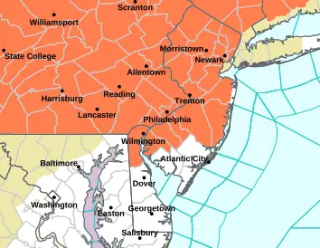
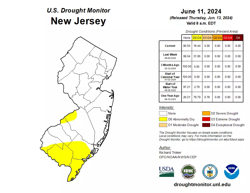
This is the other significant concern going forward. As we have discussed, New Jersey has dried out dramatically over the last 30 to 60 days. The southwestern 20 percent of the state is now classified as "abnormally dry".
While a popup shower or thunderstorm is possible over the course of this heat wave, it seems unlikely. Those odds go up slightly at the end of the week, around Friday-Saturday, as a weak disturbance passes to our north. But unfortunately, our next chance for something organized and widespread is not until early next week.
Final Thoughts
We are probably looking at about 7 or 8 days in a row of someone in New Jersey hitting 90+ degrees. The heat will be unseasonable, upwards of 15 degrees above seasonal normals. It will be uncomfortable, with gallons of sweat pouring across New Jersey. But I would not classify it as "extreme" or "historic".
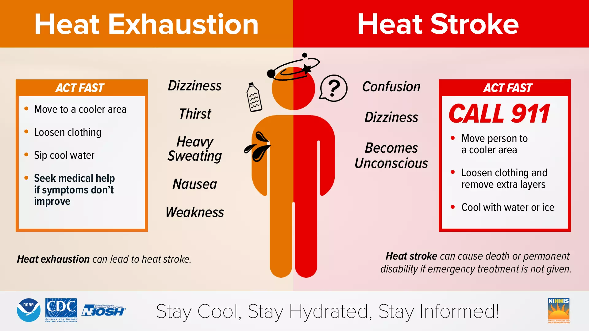
Common sense heat tips apply. Dress for the weather and stay extra hydrated. If you are out working in the heat, take frequent breaks. And try to limit strenuous activity to the early and late parts of the day, when it is naturally cooler.
Air conditioning will be your friend this week, to battle the heat, humidity, and inevitable poor air quality. However, keep in mind, residential air conditioners are generally designed to cool outside air about 20 degrees. Any more than that, and they have to run nonstop and struggle to reach the desired temperatures.
Tips on How You Can Survive a Heat Wave
Gallery Credit: Tiffany
Dan Zarrow is Chief Meteorologist for Townsquare Media New Jersey. Follow him on Facebook for the latest forecast and realtime weather updates.
Fun Indoor Activities to do During a Heat Wave
Gallery Credit: Stephanie Crist
More From New Jersey 101.5 FM