Sunday snow update: Winter Storm Warning, 6+ inches for South NJ
It's snowing! And I've seen several reports of poor conditions across the southern half of the state (even major roads). Please exercise some common sense before venturing out to work, church, the store, etc.
With snow now falling and accumulating in southern New Jersey, my policy is to not issue a new detailed snow map. I've found it just becomes confusing to communicate whether the forecast refers to "total" snowfall or "subsequent" snowfall or something else. And it's really hard to draw, not knowing exactly how much snow is already on the ground.
So far, the storm has behaved well according to forecast. It's still a glancing blow for New Jersey, with impacts ranging from "hardly anything" in North Jersey, to "conversational snow" in Central Jersey, to "plowable snow" in South Jersey. I-195 seems to be the dividing line between "wintry" and "not that snowy". If you don't have to be out driving amongst the low visibility and icy roads, it's quite pretty to watch!
We are in the peak of the storm Sunday morning, with snowfall largely tapering off for northern and central NJ by late morning. The concern, however, is that NJ's southern coast will remain under light to moderate snow through the afternoon. And the evening. And the overnight. And possibly all the way through early Monday morning. That's why the snow total forecast was increased at the last minute.
Let's break down what to expect for the rest of this snowy weekend, county-by-county:
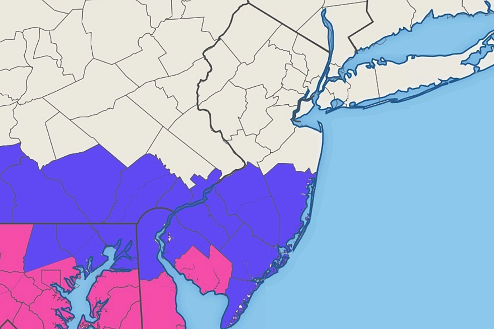
Cumberland County... NJ's snow bullseye, with upwards of 6+ inches on the ground by the end of the storm. Overnight, the advisory for Cumberland was upgraded to a Winter Storm Warning, in effect until 4 a.m. Monday. (The placement of this warning — a single NJ county — is a bit odd. But I guess NWS determined that is the most likely location for a half-foot of snow by Monday morning.) As I mentioned, moderate to heavy snow Sunday morning will taper to lighter snowfall by the afternoon. Snow may continue to fall (and accumulate) here through early Monday morning.
Atlantic and Cape May counties... Almost in the bullseye, but totals may be mitigated slightly by mixing and/or geography. I'm still thinking 3 to 6 inches of total accumulation here. The Winter Weather Advisory has been extended now also running through 4 a.m. Monday. (If things get more serious, and heavy snowfall sticks around a little longer, I could see an upgrade to a warning here at some point.)
Salem, Gloucester, Camden, Burlington, and Ocean counties... Healthy snowfall continues through Sunday morning, likely tapering off by early afternoon. While there could be additional snow shower activity through Monday morning, this area is expected to fall out of that "lingering" snow band at the tail-end of the storm. Total snowfall will likely end up around 2 or 3 inches here (maybe a little more in Salem). A Winter Weather Advisory remains in effect until 1 a.m. Monday.
Mercer and Monmouth counties... You fall right on the edge of the heaviest snow bands. There could be an inch or two of total accumulation in the southern part of these counties. Not enough to trigger an official advisory, but there could be a period of sloppy travel regardless.
The rest of the state... North Jersey, this ain't your storm. Yes, snow has fallen in all 21 counties of New Jersey. Yes, there has been some accumulation. (Looking out my window here in Union County, my car and sidewalk is already coated.) Yes, roads might be slippery for a while. But conditions should improve by around midday.
So it is not a major, state-crippling, bread-and-milk storm. But it's not exactly minor in South Jersey either — especially with snowfall potentially continuing through the start of Monday morning's commute. Here are some good resources to help you plan your day and stay safe in the storm:
Whether you love or loathe wintry weather like this, I hope you stay smart and safe and warm out there. Our news, traffic, and weather teams will continue to push updates until the final flakes fall.
More From New Jersey 101.5 FM


