

Snow, wind, cold: 9 things to know about NJ’s weekend nor’easter
1.) BOTTOM LINE: This will be a significant winter storm for most of New Jersey.
All signs are still pointing to a very "wintry" start to New Jersey's final weekend of January. Double-digit snowfall along the coast. Near-zero visibility at times. Below-zero wind chills. While there's still a chance for some last-minute wiggles and wobbles in the storm track, this forecast is now about as confident and certain as it can be.
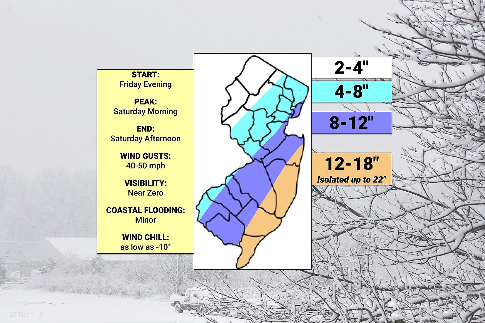
There should be no huge surprises contained in this final forecast update. Having said that, I did make a few tweaks to my snow map, pushing snow totals up for a few areas:
--Added Cape May county to my orange 12-18" snow contour.
--Pushed the dark blue 8-12" contour ever so slightly to the west.
--Made a westward shift to the light blue 4-8" contour, now encompassing most of Passaic, Morris, and Hunterdon counties.
--Removed the "plus" from the "sweet spot" along the coast, qualifying that I calculate maximum snowfall to potentially hit 22 inches.
--Bumped the lowest snow contour in NW NJ to 2-4" (previously 1-4").

2.) BLIZZARD: It has nothing to do with how much snow falls.
"Blizzard" conditions are about dangerous, difficult, if not impossible travel conditions. But it doesn't matter if one inch or a hundred inches of snow falls.
The technical definition of a blizzard requires four things:
--Sustained winds or frequent gusts of 35+ mph
--Reducing visibility below a quarter-mile
--Due to falling or blowing snow
--For at least three hours
I wouldn't be surprised at all if we meet that criteria on Saturday. Especially near the snowier, windier Jersey Shore.
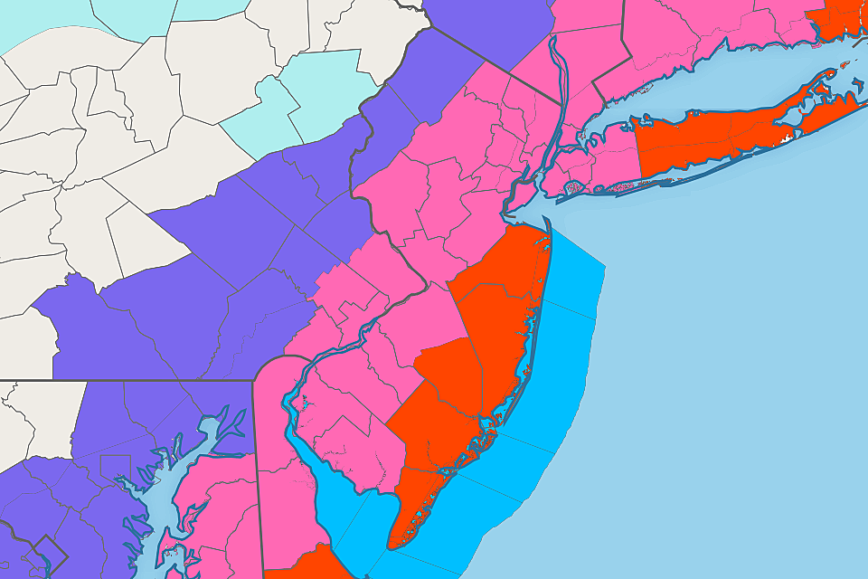
A Blizzard Warning goes into effect at 7 p.m. Friday evening through 7 p.m. Saturday evening for Monmouth, Ocean, southeastern Burlington, Atlantic, and Cape May counties.
A Winter Storm Warning has been posted for most of New Jersey for the same time frame. Plowable snowfall will cause several hours of very poor conditions.
A less-severe, less-urgent Winter Weather Advisory covers Sussex and Warren counties, cautioning of slippery (although not totally impassable) roads.
3.) STATE OF EMERGENCY: It means absolutely nothing for most New Jerseyans.
Just a reminder that the "State of Emergency" issued by Gov. Murphy on Friday probably does not affect you. By itself, it does not enact any kind of stay-at-home order or travel ban. (Although commercial truck traffic is being restricted for safety.) It does not automatically cancel or close anything. (Although state employees were sent home early Friday afternoon.)
A State of Emergency is all about money. It opens resources and funding sources specifically for emergency management purposes, so officials can prepare for the storm and clean up afterwards.
4.) TIMELINE: The brunt of the storm will be Saturday morning.
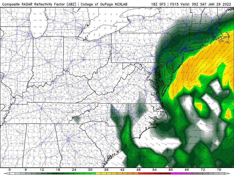
Following pockets of light snow that coated the ground over parts of New Jersey during the day Friday, we are anticipating the arrival of the "main event" nor'easter Friday evening.
--First Flakes... The storm will ramp up Friday evening. About 6-7 p.m. for the southern half of the state. By 9-10 p.m. it should be snowing just about everywhere.
--Heaviest Snow... Snowfall intensity will really ramp up along the Shore between about Midnight and 3 a.m. Saturday. Moderate to heavy snow bands will continue impacting the state until about Noon.
--Strongest Winds... Those 40-50 mph gusts will likely happen in a window between 5 a.m. and 11 a.m. Saturday morning. Other times will be breezy to windy, but those will be the fiercest gusts.
--Wrapping Up... As the coastal low shoves east and as dry air moves in, snow should taper off Sunday afternoon, between about Noon (along the Delaware River) and 5 p.m. (along the oceanfront).
5.) SNOW: Biggest snowfall accumulations will be along the Jersey Shore.
--12 to 18 inches (isolated totals to 22")... The one truth that's been threaded through every forecast this week: It's a coastal storm, so the snowfall "sweet spot" will be right along the coast. No warm ocean causing mixing problems. Just a good ol' fashioned snow storm.
--8 to 12 inches... Major/heavy snow accumulations may occur as far inland as the NJ Turnpike corridor, approximately.
--4 to 8 inches... A sharp cutoff will occur somewhere over inland New Jersey, along or just northwest of the NJ Turnpike corridor. It's impossible to pinpoint the exact location of that line. This area is really "boom or bust" - you'll probably see either 4 or 8 inches of snow.
--2 to 4 inches... Northwestern New Jersey, this still ain't your storm. (Heck, it really hasn't been your winter so far.) But you could still see shovelable snow in the end. (If there's any area of the state I'm less confident about, it's here - I'm concerned the very dry air could ultimately lead to little to no snowfall.)
6.) WIND: Top wind gusts will blow 40-50 mph.
As the center of this powerful area of low pressure passes by our latitude, that pressure gradient will kick up some strong winds. On the order of 40 mph across most of New Jersey, possibly pushing past 50 mph along the coast.
That is enough to cause sporadic power outages, especially when combined with the weight of snow and ice.
It will also blow the powdery snow around, severely reducing visibility. (See the definition of a "blizzard" above.)
The wind will also cause snow to drift significantly against walls, fences, etc.
And finally, those gusts will contribute to the next two storm impacts: Coastal Flooding, and Wind Chills.
7.) SURGE: Only one round of coastal flooding to worry about.
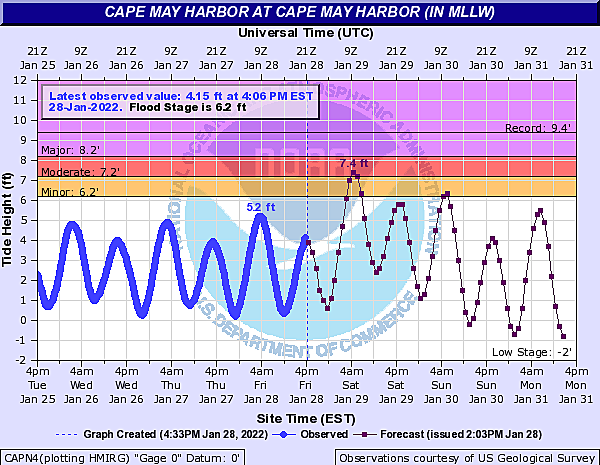
Saturday morning's high tide cycle will occur around the 4 a.m. hour along the Atlantic Ocean. Closer to 6-7 a.m. for back bays and tributaries.
Luckily, it's not a straight on-shore (easterly) wind. But a north-northeast wind will fill up bays and present storm surge on the order of 1 to 2 feet. That's enough to push tide levels past minor flood stage. That leads to water inundation in "the usual spots" along low-lying roadways, etc.
There is one tidal gauge, on the Delaware Bay side of Cape May suggesting a brief visit into the "moderate flooding" category, which would be even more impactful.
Therefore, Cape May County has been upgraded to a Coastal Flood Warning, in effect from 2 a.m. to 10 a.m. Saturday.
The rest of the Jersey Shore falls under a Coastal Flood Advisory.
8.) COLD: Wind chills will enter the "danger zone".
Both low and high temperatures on Saturday will be no higher than the lower 20s. As the wind kicks up, the wind chill (or "feels like" or "apparent" temperature) will be stuck in the single digits for most of the day. That's frigid!
The coldest is yet to come though. After the storm wraps up, temperatures drop even further Saturday night into Sunday morning. Thanks in part to the fresh snow cover, thermometers will dip into the single digit. And the wind chill will probably dip to about 0 to -10 degrees.
When the wind chill drops below zero, we call it "dangerous cold". It doesn't take long for frostbite and hypothermia to become a problem. You'll want to limit your time outside in such extreme cold. And bundle up warmly, in many layers, if you do need to go somewhere.
9.) FINAL THOUGHTS: What a wild week, what a wintry weekend.
Following the ups and downs, highs and lows of this tricky, precarious coastal storm forecast has been an interesting ride. I like to say we have learned a lot from the misses and busts of the past, playing out the evolution of this forecast very slowly and very carefully. Of course, only time will tell whether those precautions will matter and whether our hours of analysis will pay off.
Hopefully you're able to hunker down for the duration of the storm, with shovels, salt, hot chocolate, and fun snow day activities at the ready.
Our full team is on Winter Weather Alert for the duration. You can catch traffic and weather updates every 15 minutes on your radio. Or listen live via our mobile app.
We'll push relevant updates out via social media, app alerts, and web site articles too. I'll post a mid-storm weather blog update early Saturday morning. (Although this will be my final snow forecast map - I don't update that one the snow starts to fall.)
Be smart. Stay safe. Keep warm. Have fun. And good luck!
Dan Zarrow is Chief Meteorologist for Townsquare Media New Jersey. Follow him on Facebook or Twitter for the latest forecast and realtime weather updates.
The Blizzard of '96 Revisited: Snow totals for every NJ county
Gallery Credit: Joe Votruba
What would you do with a slice of cheese?
Gallery Credit: Steve Trevelise
More From New Jersey 101.5 FM


