

Snow is a ‘go’ for part of NJ Monday: Timeline, totals, and more
UPDATE... This article is outdated...
For the latest storm forecast information, please refer to my newest weather blog post.
The Bottom Line
As we approach the heart of the winter season, the coldest weeks of the year are upon us. And I do mean COLD — over the next two weeks, above-freezing temperatures are going to be very scarce across New Jersey.
Yes, I know it's winter. I know it's January. But even this is unseasonable, as high temps consistently run at least 5 to 10 degrees below normal.
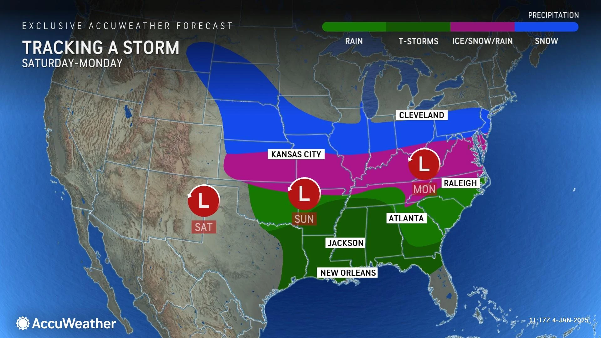
Given the chill, it should be no surprise that we also have some snow to talk about. A clipper system is expected to pass just south of New Jersey on Monday. And it will clip at least part of New Jersey with impactful, shovelable, plowable snow.
The bottom line: The farther north in NJ you are, the more like you are to see nothing at all from this storm. The accumulation forecast in South Jersey remains challenging and precarious. But we are starting to get an idea of the potential magnitude of this storm, giving us an idea of potential impacts. Again, Monday is the day.
Let's not blow this out of proportion: This is not a blizzard. This is not a snow bomb. This is not a "historic" winter storm. The potential is there for "heavy" or "major" snowfall to the south, but it is not a slam dunk. Impactful is the right word here.
This winter storm forecast really comes down to a battle between 1.) the broad dome of cold, dry air, 2.) the storm track, and 3.) the fluff factor of the snow. Forecast confidence is still shaky. And the margin of error is tight — honestly, 30 miles could make the difference between whether you see light snow or heavy snow.
Let's jump into the full forecast rundown here. These details will continue to evolve and be refined in the ~40 hours between now and first snowflakes.

The Weekend
First of all, both Saturday and daytime Sunday look quiet, dry, and quite cold.
High temperatures will only reach the lower 30s both days. Add in a brisk wind — regularly gusting above 20 mph on Saturday — and wind chills will end up deep in the 20s. Definitely time to bundle up.
There could be a few flurries flying around. But there is no risk of substantial snow until very late Sunday night.
Storm Timeline
First flakes. The initial band of snow is likely to push into southwestern New Jersey late Sunday night. More likely early Monday morning, around 2 a.m. In general, Monday morning's commute should be wintry, but tolerable. Central and northern NJ should not expect flakes until well after daybreak Monday.
Brunt of the storm. The heaviest snow bands are likely to develop in South Jersey late Monday morning into early Monday afternoon. That will be the time of greatest travel concerns and fastest accumulations. This is largely a daytime snow event.
Final flakes. The storm will start to wind down by late Monday afternoon, after about 2 p.m. However, the latest guidance suggests a redevelopment of snow as the storm reaches the coast. So I can not guarantee the complete end of wintry weather across the Garden State until late Monday night — let's call it about 2 a.m. Tuesday morning.
Accumulations
The latest few runs of our forecast models have shown a general decrease in expected snowfall. That means the cold, dry high pressure to our north wins out, pushing the clipper system further south (away from New Jersey).
However, as I mentioned, we still have 40 hours to go until first flakes. And there are still several pieces of evidence promoting more substantial snow:
1.) A very dry snowfall ratio of about 15:1.
2.) There is still a good opportunity for the storm track to shove northward again.
3.) This should be an "all snow" storm for New Jersey. Those often surprise with higher-than-anticipated accumulations.
So here is what I settled on for my initial snow forecast map.
North Jersey, this is not your storm. You might not see any snowflakes at all.
South Jersey, I am increasingly confident that you will see some shovelable snow on the ground by Monday night. Do you need to raid the grocery store for bread and milk? No — roads will probably be fine by Tuesday morning. Could we see a "Snow Day" or two for South Jersey kids? Yes.
When I draw a snowfall map, I like to plot numbers that I believe have an equal chance of "busting" high and low. In other words, there is no such thing as a "perfect" snow forecast here in New Jersey. But I'm going to get as close as I can, with realistic numbers, backed by model guidance and analysis — fully knowing that the numbers may need to change as additional information becomes available (i.e. future model runs).
In this case, I believe there is an equal chance of each contour on my map needing to upgrade to one category higher and/or downgrade to one category lower. It is all about following the "wiggle" of the storm track.
So let me try something new and add some "maximum" and "minimum" snow ranges to illustrate the upper and lower bounds of this thing.
I am well aware that the overall range of possibilities in the southern half of the state is huge. Literally from 1 to 12 inches! That is just the kind of storm situation this is. I am comfortable with the "official" 4 to 8 inch range I have released publicly. Let's see how that needs to change over time.
Impacts / Action Steps
There is a legit shot at a good ol' fashioned snow storm in southern New Jersey, if the snowy-case scenarios play out. A "South Jersey Special," if you will. Parts of South Jersey have not experienced accumulating snow in a while, so #TeamSnow fans will be very happy here.
A Winter Storm Watch has been issued for 8 counties in New Jersey in advance of Monday's snow, technically in effect from 2 a.m. Monday to 2 a.m. Tuesday. NJ counties included are: Atlantic, Burlington, Camden, Cape May, Cumberland, Gloucester, Ocean, and Salem.
A watch is a formal heads-up that hazardous weather may occur. More specifically, watch criteria in that section of the state is 5+ inches of snow from a single storm. Those in the watch area should consider preparations for travel disruptions, school closings, and shoveling.
If the forecast holds, the watch will become a warning (likely tomorrow).
After the Storm
Tuesday, Wednesday, and Thursday will be sunny but cold. In areas with fresh snow cover, overnight low temperatures will easily dip into the teens. As I mentioned, daytime highs will struggle to pass the freezing mark, in the lower 30s.
There is another storm system worth watching for next weekend, centered around Saturday. This one has more of a coastal storm (nor'easter) track. But seven days out, there is still a wide range of possible outcomes on the table for New Jersey, ranging from completely out to sea to big snow. If that becomes a "thing," we will start talking seriously about it in a few days. (First snow map probably on Wednesday.) Not before.
How to prepare for winter in NJ: 11 essential gear tips
Gallery Credit: Judi Franco/New Jersey 101.5
Dan Zarrow is Chief Meteorologist for Townsquare Media New Jersey. Follow him on Facebook for the latest forecast and realtime weather updates.
Glossary of NJ winter weather words and phrases
Gallery Credit: Dan Zarrow
More From New Jersey 101.5 FM


