

From nice to nasty weather for NJ: Rainy, windy, snowy, and cold this weekend
UPDATE... This article is outdated...
For the latest winter storm forecast information, please refer to my newest weather blog post.
UPDATE as of 6:30 p.m. Friday...
I think this is the 3rd time this winter season we've had a rain-to-snow cold front kind of situation. And, as I've mentioned endlessly, those traditionally don't produce much snow accumulation. That's because cold air, by definition, is dry air. And especially here in March, with a warm (and eventually wet) ground, it can become very difficult for snow to accumulate.
However, reviewing the latest model guidance, there are a few reasons for extra concern, and an overall increase in snowfall expectations tomorrow:
1.) Once again, this afternoon's model run trended east and earlier. Snowfall accumulations will depend largely on the timing and speed of the transition from rain to snow. So a sooner, quicker flip will likely lead to more snowfall.
2.) The dry air will arrive in two waves. Dew points will drop into the 20s initially. Not bad for snowfall - so that snowfall machine won't necessarily shut off immediately. They'll drop into the bone-dry single digits at night as our new air mass continues to push in.
3.) This is going to be a very "dynamic" storm, expected to intensify rapidly over the ocean. And we may very well see some very heavy snow bands develop. "Puking" pouring snow can overcome even the warmest, wettest ground.
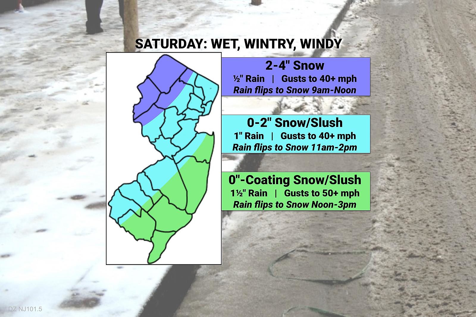
At this point, I am not going to redraw my snow/impacts forecast map until early tomorrow morning. But I would probably follow the general trend of bumping snow totals up, by about an inch. Let's say 3-6" NW, 1-2" Turnpike corridor, 0-1" coast. (A bit lower than the overall consensus, I think. But that feels comfortable to me.)
In summary, tomorrow's mess will all come down to the all-important question: Will it stick?
UPDATE as of 4:30 p.m. Friday...
Just a little update on advisories for tomorrow's messy storm. The forecast has trended a bit snowier.
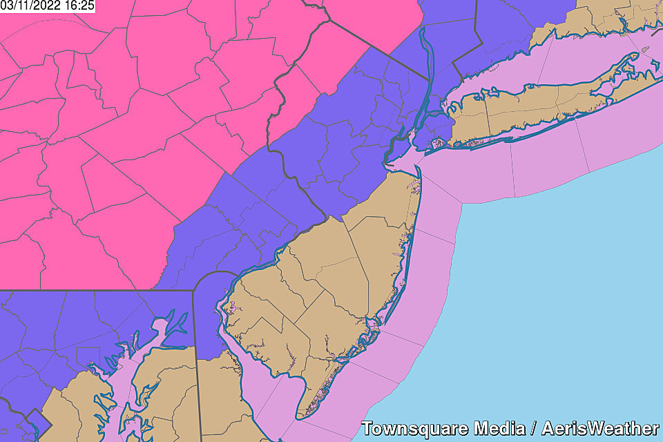
So we now have Winter Storm Warnings (pink) posted for Sussex and Warren counties, from 6am to 7pm. Winter Weather Advisories (purple) along and NW of the Turnpike. And a Wind Advisory (tan) for most of NJ too.
The rain-snow timeline hasn't changed. Nor the threat for gusty winds, bitter cold, and a flash freeze.
I'll put out a final forecast update first thing tomorrow morning. The weather will be a good excuse to just stay in bed all day!
ORIGINAL POST from 7:17 a.m. Friday...
The Bottom Line
The big weather headline here is the powerful storm system that will slide across New Jersey on Saturday. You may have seen or heard some dramatic "doom and gloom" forecasts. And yes, it is definitely going to be a nasty, stormy, inclement day. All day long.
There is a risk of severe weather, flooding, damaging winds, accumulating snow, and bitter wind chills. That's a lot to deal with from one storm system! But the threat of truly "dangerous" conditions is pretty limited. The world is not coming to an end here.
Friday: Nice
Thursday was pretty pleasant and comfortable, and Friday looks even better. We're off to a chilly start, with temperatures in the 20s and 30s. By Friday afternoon, we'll see highs reach the mid 50s. A few degrees warmer than Thursday, and a few degrees warmer than Thursday. The only exception: The Jersey Shore, under the influence of the sea breeze machine, stuck in the 40s.
Skies will be mostly to partly sunny, with dry weather and light winds.
Friday evening looks good too, although conditions will start to slip downhill. Look for increasing clouds. And the chance of rain will start shooting up between Midnight and daybreak Saturday morning. Overnight low temperatures will be above freezing, around 40 degrees.
Saturday: Nasty
From rain to snow to wind to cold, Saturday is going to be full of twists, turns, and unpleasantries. Since we last spoke, the storm track has shifted slightly east and slightly earlier. That is a somewhat colder and snowier solution for New Jersey. Although please temper your hopes of building a snowman here.
Let's run through the general timeline, and then we'll break down each inclement impact one by one.
—Saturday early morning... We get soaked. A batch of steady to heavy rain will impact the entire state starting in the pre-dawn hours. Gusty thunderstorms are possible.
—Saturday mid to late morning... As colder air arrives from northwest to southeast, rain will transition to wintry mix and then wet snow. Colder Northwestern New Jersey will transition first, leading to light to moderate accumulations are possible.
—Saturday midday... Expect the rain-snow line to reach approximately the NJ Turnpike at lunchtime.
—Saturday early to mid afternoon... Southern and coastal New Jersey will resist the flip from rain to snow until the afternoon hours. But it will happen eventually.
—Saturday late afternoon to early evening... Dry air will put a definitive end to snowfall. Final flakes expected by 7 p.m. at the latest.
—Saturday night... Temperatures will continue plummeting overnight, with a continuing gusty wind.
A Winter Storm Watch has been issued for Sussex and Warren counties only, in effect from 6 a.m. to 7 p.m. Saturday. I suspect we'll see additional advisories for wind, flooding, and snow at some point.

Storm Concern #1: Rain
Total rainfall early Saturday will range from about 0.5" to 1.5" across the state. (Some models even go as high as 2" from localized downpours.) That could lead to ponding and flooding of low-lying and poor-drainage areas.
Storm Concern #2: Gusty Thunderstorms
The atmosphere is going to be so churned up with so much turbulent energy, that some rumbles of thunder and gusty winds are possible. Best chance would be in southern New Jersey around mid-morning. The Storm Prediction Center even clips Cape May County with a slight risk of an isolated tornado Saturday morning.

Storm Concern #3: Snow
There are three big questions in this storm forecast, and they all relate to the wintry piece of the puzzle. 1.) When will the rain transition to mix and snow? 2.) How fast will that transition be? 3.) How quickly will bone-dry air cut off snowfall?
There have been a few outlier models that suggest upwards of 6 to 9 inches of snow in New Jersey Saturday. I don't buy it at all. It is very difficult to get significant snow accumulations from a cold front like this one. Cold air is dry air, and those plummeting dew points will put a quick end to accumulations late Saturday. (See "question #3" above.)
In addition, the ground is quite warm. And it will be quite wet due to the early rainfall. So it's going to be hard for snow to stick.
Having said that, some light accumulation is possible for most of the state. Especially right as the flip to snow happens — if those flakes fly hard and fast, it could produce a quick coating on cold surfaces.
I'll even say that "moderate" snow accumulations are possible in northwestern New Jersey, where snow will transition Saturday morning (possibly as early as 9 a.m.) Cold temperatures could be conducive for upwards of 4 or 5 inches on the ground. (But again, how much of that will actually stick, especially to warmer paved surfaces?)
Visibility and traction could become problems, making travel tricky. Don't be caught off-guard by the big change from wet to wintry — it's going to happen suddenly.
Storm Concern #4: Wind
There are three distinct wind concerns on Saturday:
1.) Pre-front, the return southerly flow will be pretty strong. (Especially as a low-level jet sets up right along the coast — strong winds about a half-mile overhead.)
2.) Heavy rain and thunderstorms can push out lots of air, called outflow.
3.) Post-front, colder air will "whoosh" in on a brisk northwesterly wind.

Top gusts could reach 40 mph (inland) or 50 mph (coast). It's going to stay windy through most of Saturday night.
Storm Concern #5: Flash Freeze
Temperatures will continue tumbling into the 20s by sunset Saturday, and probably into the teens overnight. The wet ground and puddles will almost certainly freeze overnight. Watch for sudden icy conditions on any unpaved surfaces. New Jersey could be quite a skating rink by Sunday morning.
Sunday: Cold
It's March. It's not supposed to be this cold. We're going to end up perilously close to record low temperatures.
Sunday morning, thermometers will bottom out in the teens away from urban and coastal areas. With a continuing chilly breeze, the wind chill ("feels like" or "apparent" temperature) will be in the single digits for most. Brrr!
Sunday afternoon, highs will only reach the mid 30s. Just above freezing. But a full 15 degrees below normal for this time of year. It will be a bright, sunny, dry day with winds slowly calming.
Also, a friendly reminder: Daylight Saving Time begins Sunday. That means we get to time travel, by springing your clocks forward an hour. It also pushes sunrise and sunset an hour later, to approximately 7 a.m. and 7 p.m., respectively.
The Extended Forecast
Thankfully, the unseasonable, bitter chill will only last for one day. We'll head back to work and school on Monday with a warmup on the day.
We'll be right back in the mid 50s on Monday, pushing 60 degrees on Tuesday.
Next storm system rolls in late Wednesday into Thursday. It looks like a limited rainmaker, with temperatures remaining above the freezing mark for the duration.
In fact, following that period of wet weather, another surge of warmth could push temperatures toward the 70s.
Final Thought
So is this it? Is Saturday's messy, multi-impact storm the last gasp of Winter? The Spring Equinox is just nine days away, after all.
Well, next week's warmup and rainy storm systems make a good case for those itching to put away the shovels and snowblowers. In other words, I don't see any significant winter storms on the horizon. And historically, climatologically, we are coming to the time of year when they just can't happen anymore.
Of course, it can still snow well into April here in New Jersey. Regular frosts and freezes will continue for a while too. But there are signs of warmer, brighter, longer days ahead. And I, for one, can't wait!
Be safe out there Saturday. We'll be here online and on-air with the latest updates, as always.
Dan Zarrow is Chief Meteorologist for Townsquare Media New Jersey. Follow him on Facebook or Twitter for the latest forecast and realtime weather updates.
The Ultimate Guide to New Jersey Brewpubs
Gallery Credit: Jordan Jansson
Best coffee shops & cafes near NJ beaches
Gallery Credit: Jordan Jansson
More From New Jersey 101.5 FM


