

Wet and windy Wednesday for NJ: 2″ rain, 50 mph gusts
The Bottom Line
We have reached the stormy day of the week.
Before I jump into the forecast details — timeline, totals, impacts, etc. — I want you to think back to the fall. When it was so dry, we were worried it was never going to rain in New Jersey again. Wildfires were rampant. Crops and lawns were dying. Reservoirs were perilously low.
With that perspective in mind, Wednesday's weather won't be miserable — this stormy washout is wonderful.
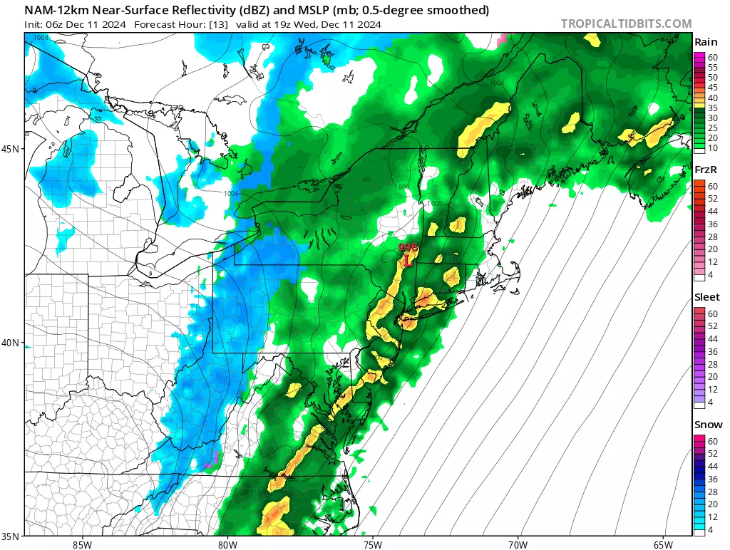
By the numbers, about two inches of rain is expected by Wednesday evening. Reduced visibility and traction will slow you down on the roads. Localized ponding and flooding issues are possible.
Wind gusts may reach 40 mph (inland) to 50 mph (coast). Power may flicker. And driving will be difficult at times.
Rumbles of thunder are possible. Widespread wintry weather is not a concern, although there is one limited opportunity for some snowflakes. (Keep reading for details.)
Once the rain winds down Wednesday night, arctic air returns. So we're back to blustery, and back to bundling up for a few days.

Wednesday
Wednesday's inclement weather will basically play out in three stages:
1.) Part 1: Periodic Rain... It is damp to start across New Jersey. And more rain is on the way. But we will find dry slots — breaks in the rain — from morning through midday. Winds are fairly light for now. It is eerily warm, with temperatures in the 50s and 60s.
2.) Part 2: The Brunt... The most impactful part of this storm system, with the heaviest rain and the strongest winds, will be Wednesday afternoon through early evening. (I do not want to pinpoint with specific times here, as there is some uncertainty and "wiggle factor" in play.) Pouring rain and strong winds will significantly impact your ride home from school and work.
3.) Part 3: Clearing and Chilling... Final raindrops are expected between about 8 p.m. and 10 p.m. Wednesday evening. As temperatures start to drop in that last hour or two, a quick transition to snow is possible in NW NJ — but no sticking, accumulation, or wintry travel issues are expected. As our weather dries out and clears out overnight, temperatures will fall sharply to around the freezing mark.
Thursday
By Thursday morning, thermometers will be around the freezing mark, in the lower 30s. A freeze, but not a hard freeze. So while there could be some icy patches and slippery spots, I do not think a widespread "flash freeze" is going to happen.
You will be "back to bundling up" Thursday morning, with wind chills ("feels like" or "apparent" temperatures) only in the 20s.
Thursday is going to be a blustery day, as the westerly wind continues to gust to 30+ mph. Despite sunshine, high temperatures will only make it into the mid 30s.
An isolated snow shower or squall is a possibility, especially in North Jersey. Fizzled lake-effect showers may lead to increased cloud cover through Thursday afternoon.
Friday
Another cold day, although not as windy. Morning lows will be quite cold, deep in the 20s. Highs will only reach the upper 30s. Again, we will call it a mostly sunny day.
Saturday
You are still grabbing the winter coat as we head into the last full weekend of fall. Saturday's highs will hit about 40 degrees. Other than the chill, Saturday's weather will be fair and dry with increasing clouds.
The Extended Forecast
Our next chance of rain comes on Sunday. But it is not a slam dunk — at least one model solution shows this storm system diving south of New Jersey. I am not worried about this one for now — worst-case scenario, it would be a quick hit of a half-inch of rain late Sunday. Nothing heavy, nothing severe, nothing wintry. Still, we'll keep an eye on it.
Temperatures will moderate into early next week. We should be in the 50s by the time our next storm system drives in rain around midweek.
We are now officially two weeks away from Christmas Day. And no, I do not have a confident forecast to share with you just yet. Both the raw GFS and Euro models show mild temperatures and rain on Christmas Day — however, a 14-day forecast is rarely accurate. So that is sure to change completely in the coming days.
Cough, cough: NJ's favorite lost voice and sore throat remedies
Gallery Credit: Dan Zarrow
Dan Zarrow is Chief Meteorologist for Townsquare Media New Jersey. Follow him on Facebook for the latest forecast and realtime weather updates.
BEEP BEEP BEEP: These are the 13 types of Wireless Emergency Alerts auto-pushed to your phone
Gallery Credit: Dan Zarrow
More From New Jersey 101.5 FM


