Tuesday NJ weather: Rain moves out, sunshine returns, mild temps
The Bottom Line
Happy first day of November! As you awaken from your Halloween sugar coma, let me tell you about the eleventh month of the year. On average, November is New Jersey's 5th coolest, 2nd driest, and 6th snowiest month of the year. It is the final month of climatological autumn, with the Winter Solstice only 50 days away.
However, this first week of November is trending quite warm. Temperatures will remain stuck above seasonal normals for the next 7 or 8 days in a row. 70+ degrees is even in play for most of those days. (A spot 80+ temperature can't be ruled out by the weekend.) There will be some gentle ups and downs along the way, but little chance of rain before next week.
Tuesday
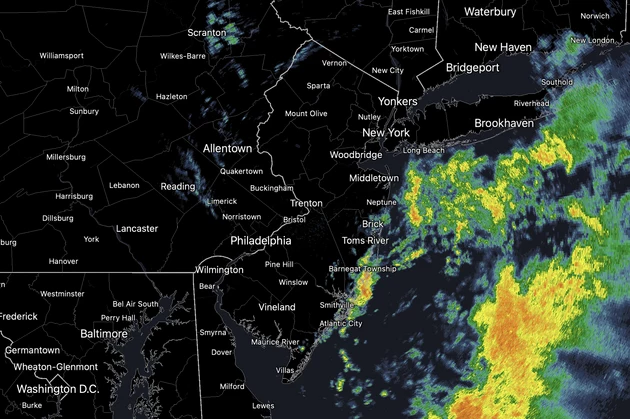
Overnight, upwards of an inch of rain fell over parts of New Jersey. A quick batch of unsettled, soggy weather — that unfortunately affected late trick-or-treating and World Series Game 3 in Philadelphia. (For what it's worth, meteorologically, it was a good idea to postpone the game as the forecast for the rest of the week looks fantastic.)
As of this writing (6 a.m.), we still have pockets of pouring rain along NJ's coastal counties. Farther inland, we still have wet roads, drizzle, mist, and fog around.
Most of the state will dry out by mid-morning Tuesday. However, there is one more piece of energy that will clip northern New Jersey. So I have to keep an isolated area of rain in the forecast through midday.
Skies will clear to sunshine across the state Tuesday afternoon through early evening. (Keep in mind, sunset continues to drift earlier and earlier, now before 6 p.m.)
High temperatures on Tuesday will reach about 65 to 70 degrees. That is 5 to 10 degrees above normal for early November. Winds will stay light. And humidity levels will gently decrease late-day.
Tuesday night will be cool, but not too cold. Frost is not a concern, even for NW NJ. Look for low temperatures across the state averaging lower 50s.
Wednesday
A storm system will pass just south of New Jersey on Wednesday. It is mainly a "miss" — we will stay completely dry. However, some extra clouds will possibly invade the southern half of the state during the day Wednesday.
So let's call Wednesday "mostly sunny" for North Jersey and "partly sunny" for South Jersey. Again, it will be dry. And Wednesday's high temperatures will be similar to Tuesday's, in the upper 60s to around 70.
Thursday
Under the influence of a slightly cooler air mass, high temperatures will be held to the mid 60s. Still above seasonal normals. You may need a jacket Thursday morning (widespread 40s). But probably not Thursday afternoon.
Again, sunny skies, light winds, dry air, and dry weather will make Thursday a lovely day.
Friday
As winds become southwesterly, temperatures will start cookin' again. We could see our warmest days in about a month.
I'll put Friday's high temperatures around the 70-degree mark. Again, with mostly sunny skies.
The Extended Forecast
Lower to mid 70s on Saturday and Sunday will be downright warm. We will see some thicker clouds creep in. (And the Euro model paints a weird on-shore breeze and sprinkles for Sunday, but don't worry too much about that for now.)
Long-range models suggest two opportunities for rain and a cooldown next week, around Tuesday and Friday. That's pretty far off. So for now, we will enjoy a brief respite of warm, dry weather. Especially since you know "snow season" is just around the corner.
Dan Zarrow is Chief Meteorologist for Townsquare Media New Jersey. Follow him on Facebook or Twitter for the latest forecast and realtime weather updates.
How is it still standing? Look inside the oldest home for sale in NJ
How much does the average NJ home cost? Median prices by county
More From New Jersey 101.5 FM


