
Tropical Storm Isaias wiggles west – heavy rain, wind, and surf still concerns
On this Sunday, New Jersey's forecast contains both strong thunderstorms and intense heat and humidity.
But at least this Isaias update contains a small sigh of relief for the Jersey Shore. As model consensus continues to firm up, the tropical storm is pointing in a slightly better direction, at least in terms of the storm surge potential. But please continue to take this storm seriously — we have to stay cautious and vigilant, given the potential rain and wind hazards.
Where is Isaias?
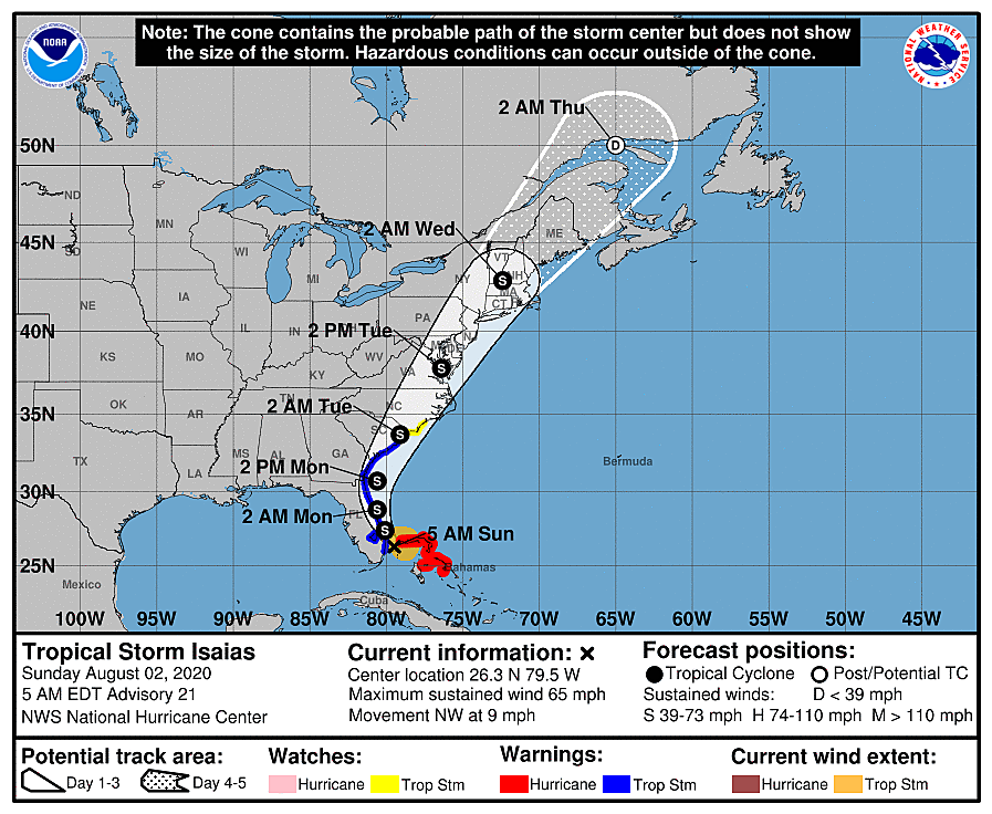
As of 8 a.m. Sunday, Tropical Storm Isaias is centered 40 miles east-southeast of West Palm Beach, Florida. That is approximately 900 miles south-southwest of Cape May, N.J. It is still a tropical storm, with maximum sustained winds of 65 mph. Isaias is crawling to the northwest at 8 mph, toward the Florida coast. Tropical storm warnings and watches now extend as far north as North Carolina.
Over the past day, Isaias has experienced some wild swings in intensity as it swung through the western Bahamas. One minute, it looks like a "hot mess." The next, convection fires up into a formidable beast.
Now that prime impacts for New Jersey are within 72 hours, we're getting a clearer, more confident view of the forecast. To put it plainly, Isaias's track has "wiggled" west — closer to the coast. That means it will scrape past the coastline of Florida, Georgia, and the Carolinas before making landfall. And then, the most likely forecast track keeps the center of the storm over land as it approaches New Jersey.
That is good news for us, for three reasons:
1.) If the storm can no longer "feed" on warm ocean water, it will not reintensify into a hurricane.
2.) Furthermore, the western side of the storm will encounter mountainous topography through North Carolina and Virginia, weakening it.
3.) The inland track and the increased speed of the storm will somewhat mitigate intense winds and storm surge along the Jersey Shore. (But not completely — keep reading.)
The exact track and orientation of the storm are still very important here. The heaviest rainfall will be found on the west side of the eye. The strongest winds will be just to the east.
Timeline
First raindrops will arrive in New Jersey Monday evening. Scattered light rain is expected through much of Monday night. The rain and wind then look to intensify during the day Tuesday.
Beyond that statement, there are still some differences amongst our model guidance regarding the timing of the peak impacts. The GFS model favors a sunrise to mid-afternoon time frame for heavy rain and wind. The NAM pushes through tropical rainfall between midday and late evening, with strong winds at the tail end of that window. The Euro is the most prolonged of all, showing bands of heavy rain from sunrise to midnight. Again, with the Euro solution, the big burst of wind would be late-day.
Given how cruddy models have been at getting a handle on this storm, I don't want to focus on the nitty-gritty hour-by-hour outlook just yet. Just know that Tuesday is going to be the nasty day.
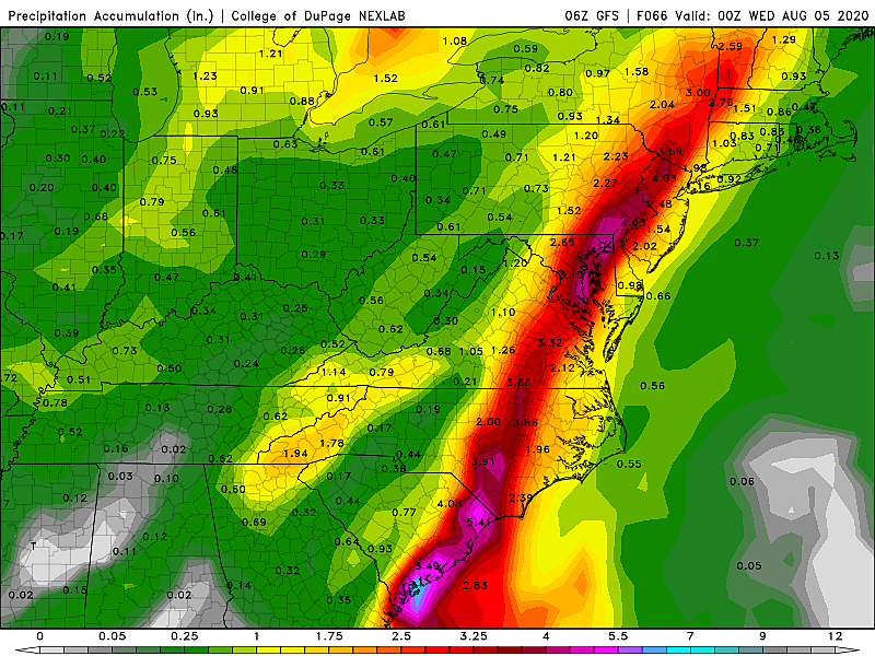
Rain
Probably New Jersey's biggest impact from Isaias.
Just as we saw from Tropical Storm Fay in July (and even more notably, Irene in 2011 and Floyd in 1999), storms of tropical origin can dump enormous amounts of rain over the mid-latitudes. And that, of course, can lead to some pretty dramatic flash flooding and river flooding.
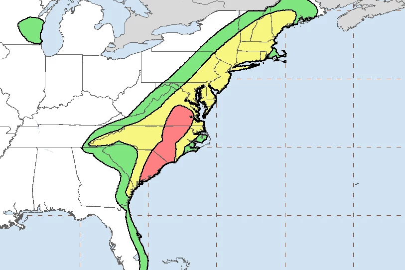
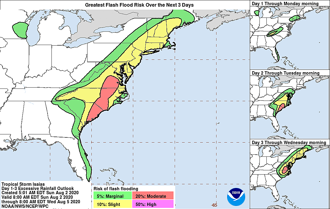
Tropical Storm Isaias will deliver a swath of very heavy rain in our area, likely on the order of 4 to 8+ inches. But will that stripe of heaviest rain end up over New Jersey? Or Pennsylvania? And there's the rub — if the storm track shifts even slightly to the west, we could actually end up with very little rainfall here (especially along the coast).
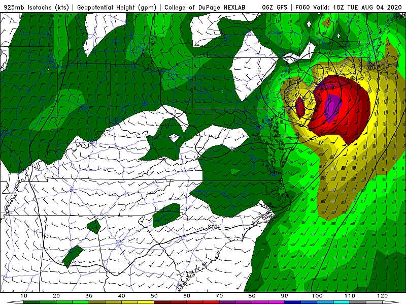
Wind
Nothing to sneeze at.
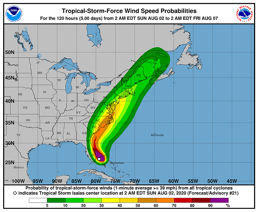
Unless the storm 1.) falls apart even more than expected, or 2.) wiggles west some more, strong wind will blow through NJ. I'd estimate 40+ mph gusts are a good bet across the state. And some models still paint 60+ mph near the coast. That's certainly enough to blow around garbage cans, bring down tree branches, and cause sporadic power outages. But I think we can back away from the notion of widespread severe wind damage at this time. Good news.
Also, please do me a favor. Don't call them "tropical storm force gusts". There is no such thing — tropical storms and hurricanes are measured by sustained winds (1-minute average), not gusts. Gale force or storm force winds would be more technically correct.
Coast
Always worth watching with a tropical storm in the neighborhood.
The ocean is already rough. There were numerous beach rescues on Saturday. And things will only get more churned up. A moderate risk of dangerous rip currents is posted once again Sunday, which may increase to high by Monday.
Big waves (10+ feet) could be a problem for beach erosion along the coast.
Even with the more inland track, there will be a period of southerly and easterly winds pushing ocean water toward the Jersey Shore. Perusing the latest surge models, I'm seeing agreement toward a foot of potential storm surge, give or take. Combined with the impending full moon and the intense wave action, we're likely facing one or two rounds of minor to localized moderate flooding of tidal waterways. The most precarious high tide cycles will be Tuesday morning (around 9 a.m. on the oceanfront) and especially Tuesday evening (9 p.m.)
The Bottom Line
Isaias is still worth watching and worth talking about, as Tuesday shapes up to be a nasty day across the Garden State. This will almost certainly go beyond a "normal rainy day" with continuing concerns over flooding, wind, and rough surf.
What do you need to do to prepare right now? Not much. No watches have been issued yet. And we've backed away from the truly "worst case scenario". Have a plan in your mind about what in your yard needs to be secured in high winds. And consider your routine on Tuesday carefully — traveling in wind-drive heavy rain and flooding conditions is going to be our biggest hassle and hazard.
Next weather blog post is planned for early Monday morning.
Dan Zarrow is Chief Meteorologist for Townsquare Media New Jersey. Follow him on Facebook or Twitter for the latest forecast and realtime weather updates.
More From New Jersey 101.5 FM


