

The big autumn chill: Skies clear, winds calm, temps drop Friday
What a nasty night! Over the past 24 hours, rainfall totals ranged from about 3/4-inch in North Jersey to over 4 inches in NJ's coastal counties. There are still a ton of flood warnings and advisories out there — too numerous to mention. Just be aware there are still some flooded roads (or wet, at the very least), especially across the southern half of the state.
Skies will dry out and clear out Friday, but our attention now turns to a significant cooldown.
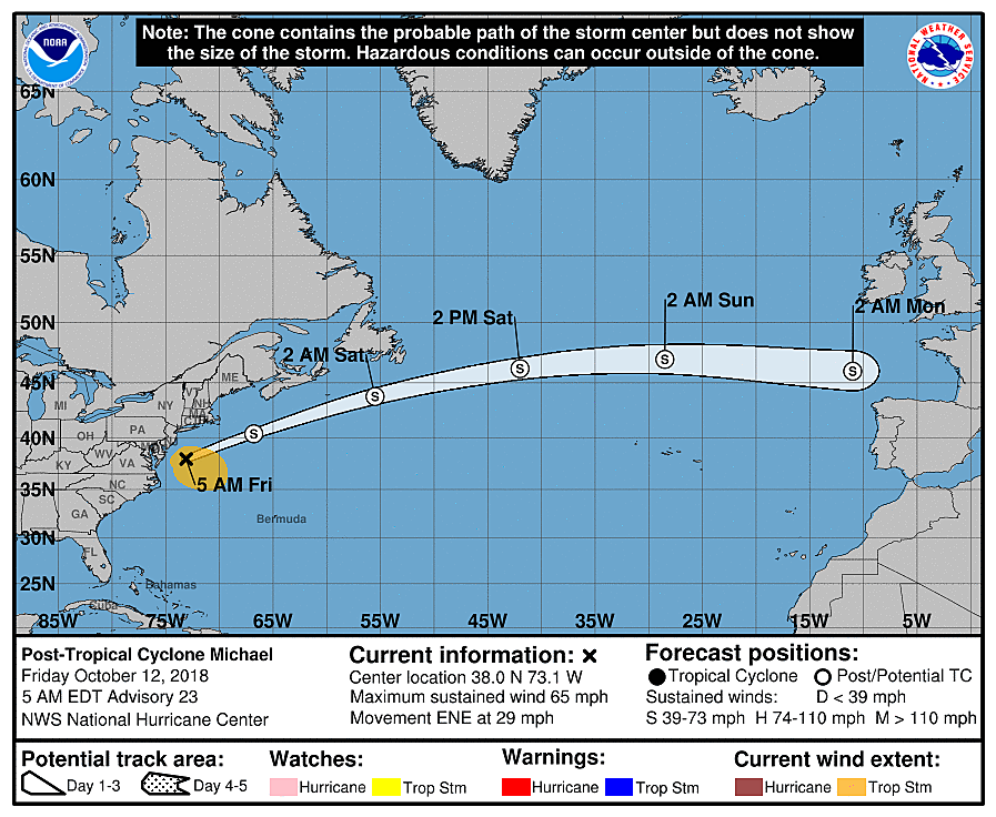
Michael is a tropical storm no more. As of 5 a.m. Friday, the storm is classified as Post Tropical Cyclone Michael. It's not really a "downgrade" — it just means the storm is becoming disorganized, and is no longer maintaining tropical characteristics. Maximum sustained winds have actually increased to 65 mph. Michael is rapidly shoving out to sea.
As of this writing (6 a.m. Friday), the steady, driving rain is wrapping up across the Garden State. I have to keep showers, drizzle, and sprinkles in the forecast through mid-morning. Then skies will quickly clear to beautiful sunshine as drier air flows in.
The top wind gust overnight was an impressive 46 mph at both Woodbine (Cape May County) and Lower Alloways Creek Township (Salem County). It will take a while for winds to really subside, but we should transition from "gusty/windy" to "breezy" by Friday afternoon.
Deciding what to wear Friday will be difficult, as temperatures tumble from the 60s (morning) to the 50s (afternoon).
And then Friday night gets even colder, of course. Overnight low temperatures should fall into the 40s for just about the entire state. It will be New Jersey's coolest night since May 1!
As a weak atmospheric disturbance crosses New Jersey in the 3 a.m. to 9 a.m. Saturday time frame, a batch of rain is possible. I'm still dubious about how widespread and/or steady the rain is going to be, given how bone-dry out atmosphere is going to be. Some have even suggested that a few wet snowflakes may mix in, around the highest elevations of far northern New Jersey. Eh. The chance isn't zero, but I don't think it's going to be quite cold enough. It'll be close!
Sunshine takes over by Saturday afternoon, and it will turn into a delightfully refreshing and dry autumn day. Thermometers will struggle to even reach 60 degrees — that's about 5 to 10 degrees below normal for mid-October.
Saturday night to Sunday morning will probably be even colder, with low temperatures potentially dipping into the 30s in NW NJ and the Pine Barrens. (If, and only if, skies remain clear enough and winds stay light enough.) Once the thermometer drops to about 37 degrees, frost is possible. (The very coolest air pools right along the surface, allowing those little ice crystals to form on blades of grass, leaves, metal surfaces, etc.) This will be our first frost of the year, pretty much right on schedule according to climatology.
A brief shower or sprinkle is possible to start Sunday, but the rest of the day looks fine. Look for partly sunny skies with high temps improving slightly to the lower 60s.
Our forecast will remain cool and a bit unsettled through early next week. Monday will be our "warmest" day of the week — but that's not saying much, with highs in the upper 60s to around 70. We dip back into the lower 60s through midweek. Monday, Tuesday, and Wednesday each feature a chance for scattered rain showers too. High pressure and sunny skies return late-week.
Have a great weekend! Dress warm!
Dan Zarrow is Chief Meteorologist for Townsquare Media New Jersey. Follow him on Facebook or Twitter for the latest forecast and realtime weather updates.
More From New Jersey 101.5 FM


