

Steamy and stormy Wednesday: Wind, hail, and flooding possible
FLASH FLOOD WARNING in effect for central Mercer County until 8:15 p.m. Doppler radar indicated thunderstorms producing heavy rain across the warned area. Up to two inches of rain have already fallen. Flash flooding is expected to begin shortly in the areas of heaviest rain.
SEVERE THUNDERSTORM WATCH in effect for the entire state of New Jersey until 9 p.m.
SEVERE THUNDERSTORM WARNING for north central Burlington and central Mercer counties until 2:15 p.m. for a severe thunderstorm was located over Florence-Roebling, or 7 miles southwest of Trenton, moving
northeast at 15 mph with 60 mph wind gusts and half dollar size hail.
SEVERE THUNDERSTORM WARNING issued for Hunterdon, SW Morris, NW Somerset and south central Warren counties until 2 p.m. Severe thunderstorms were located along a line extending from near Califon to Frenchtown, moving northeast at 20 mph with 60 mph wind gusts and penny size hail.
Thankfully, it's been a while since we've had to talk about big, bad thunderstorms. They're back in the forecast Wednesday, and could present some challenges for the evening commute.
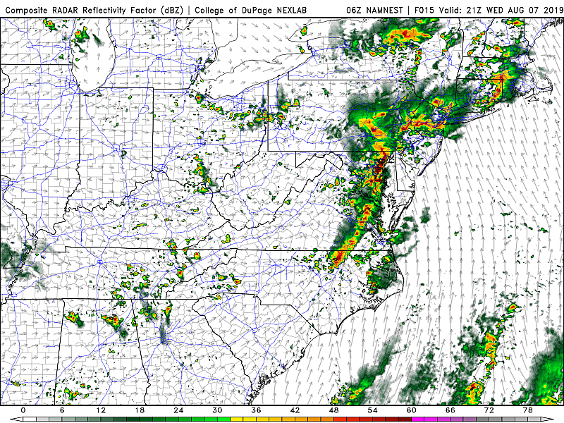
As of this writing (5:30 a.m.) there are two batches of leftover overnight convection — one in North Jersey, and one hugging the southern coast. As that exits by around 7 a.m., we'll see partly sunny skies for the rest of Wednesday morning. It will be somewhat breezy and very muggy. High temperatures should spike into the 85 to 90 degree range by early afternoon.
Then our attention turns to an approaching cold front that will spark some thunderstorms Wednesday afternoon, starting around 2 p.m. Storms will likely form and grow very quickly, making it extra important to stay "weather aware" all day.
My biggest concern from these initial storms will be damaging winds, potentially in excess of 60 mph. This will happen both in and out ahead of any strong storm cells.
Pockets of very heavy rain are also pretty much guarantee, which may lead to flash flooding issues during the Wednesday evening commute. Depending on which forecast model you like, top rainfall totals in NJ range from 2" to about 5". Just to be clear, not everyone in the state would see that much — that's just the maximum.
Hail is also possible. And a tornado can't be ruled out, especially in NW NJ where winds will be most conducive to twisting up.
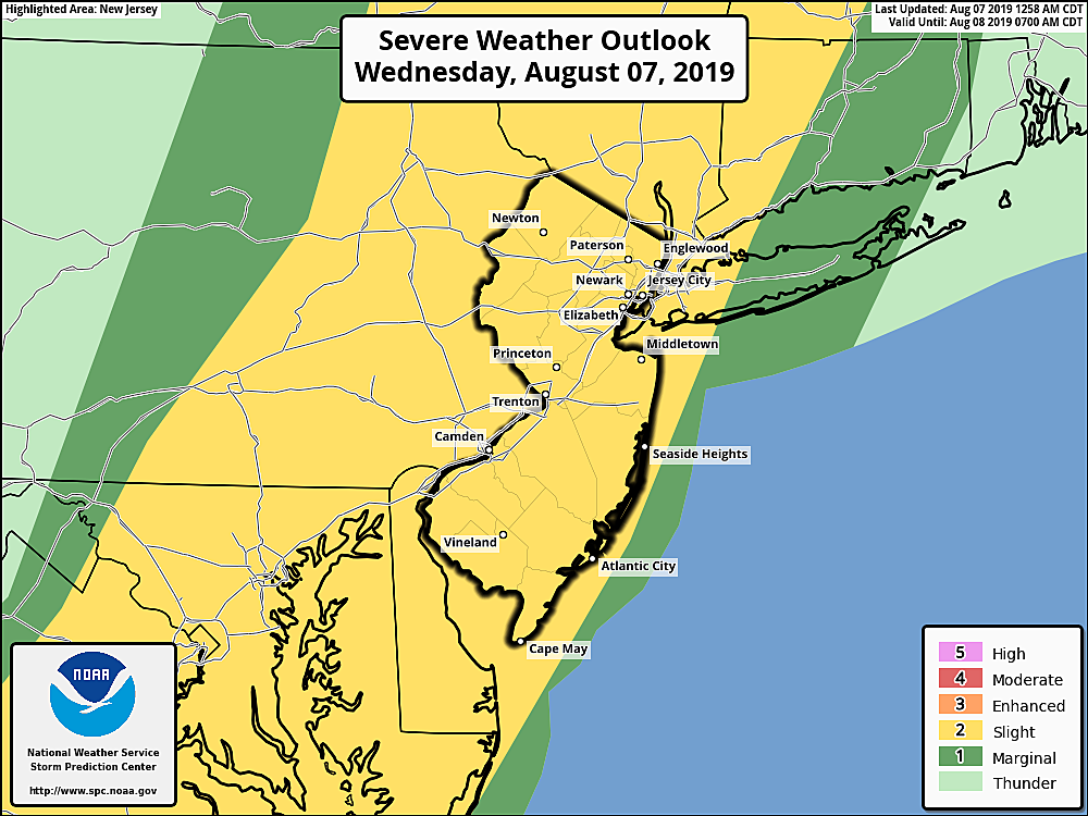
As the map shows, the Storm Prediction Center has painted the entire state of New Jersey in a "Slight Risk" of severe weather. I know that terminology doesn't sound very serious. Even more so when you consider this is the second lowest of the five severe weather risk categories. It actually translates to a 15% chance of severe wind (58+ mph) within 25 miles of any point in the yellow area. That's pretty significant, and pretty widespread. It's going to get nasty.
Wednesday evening will be stormy too, although thunderstorm intensity should calm a bit as sunset approaches. We should see rain exit the state by late Wednesday evening, with a drying trend taking over Thursday morning. Patchy fog is likely overnight.
The aforementioned cold front won't really do much to cut through the heat and humidity. Thursday will be calmer, ever-so-slightly cooler, and a bit less humid. As skies progress from clouds to sun, we'll see high temperatures in the mid to upper 80s. Isolated showers are possible as a second cold front arrives late-day.
That second cold front will (finally) open the door to much drier air. You'll feel humidity nosedive by Friday morning in North Jersey. (More like Friday evening along the southern coast.) Friday looks like a beautiful weather day, with mostly sunny skies and seasonably warm temps in the mid 80s. Even though model guidance hints at a shower chance, I've opted for a dry forecast.
And we'll keep the deliciously dry air and delightfully dry weather going through the weekend. Saturday should be bright and sunny, with highs in the lower 80s. We'll see partly sunny skies and highs in the mid 80s on Sunday. Thermometers will end up a little bit cooler right along the Jersey Shore, thanks to a sea breeze. Hopefully 70s won't be too cool to enjoy the sun and surf!
Next rain shower chance will come along on Monday.
Dan Zarrow is Chief Meteorologist for Townsquare Media New Jersey. Follow him on Facebook or Twitter for the latest forecast and realtime weather updates.
More From New Jersey 101.5 FM


