

Snow bookends first weekend of 2025 for NJ: 2″ Friday, 6+” Monday
UPDATE... This article is outdated...
For the latest storm forecast information, please refer to my newest weather blog post.
The Bottom Line
That's right, we are tracking not one but two imminent chances of accumulating snow here in New Jersey.
Overall, late Friday's wintry weather is minor, and really limited to the southern half of New Jersey. But icy, slushy roads are possible through the evening commute. Bad timing for "nuisance snow" — a Winter Weather Advisory has been issued for South Jersey.
The second storm system is set to arrive on Monday. It will be much more impactful and more widespread. But we are still not ready to lay out a detailed timeline or talk about specific accumulation numbers just yet.
I really hate forecasting multiple winter storms at one time. The messaging gets muddled. And "chaos theory" kicks in, where we really do not have a good view of the second storm forecast until the first one wraps up.
Meanwhile, New Jersey's weather looks quite cold for the foreseeable future. Do not expect any warmup for the next two weeks, at least.

Friday: Southern Burst of Snow
Much of South Jersey has not seen measurable snow yet this season. Only a Trace — less than a tenth of an inch — has been recorded at Atlantic City International Airport in Egg Harbor Township.
That likely changes on Friday, with a brief round of light to moderate snow on the way.
Friday begins with chilly temperatures, around the freezing mark. That by itself is not too bad — but the brisk wind is pushing wind chills ("feels like" or "apparent" temperatures) deep into the 20s. It's another "bundle up" day.
It will remain chilly and breezy Friday, with high temperatures only reaching about 35 to 40 degrees. Early sunshine will give way to substantial clouds through the afternoon.
As a storm system clips New Jersey from the clip Friday afternoon, snow chances will ramp up for the southern third to half of the state starting around 3 or 4 p.m. Through Friday evening, snow will stick and accumulate, potentially leading to poor visibility and slick road conditions. Snow should exit the Garden State by around 9 or 10 p.m.
The National Weather Service has issued a Winter Weather Advisory from 3 p.m. to 10 p.m. Friday for six South Jersey counties: Atlantic, Cape May, Cumberland, Salem, Gloucester, and Salem. An advisory cautions that light to moderate snow/ice could cause slippery travel conditions.

It still looks like an inch or two of total accumulation is a good bet for much of inland South Jersey. A coating to an inch is a possibility as far north as the Interstate 195 corridor. Some rain may mix in along the immediate coast too. For the northern half of the state, this just is not your storm — don't expect much more than flurries, if that.
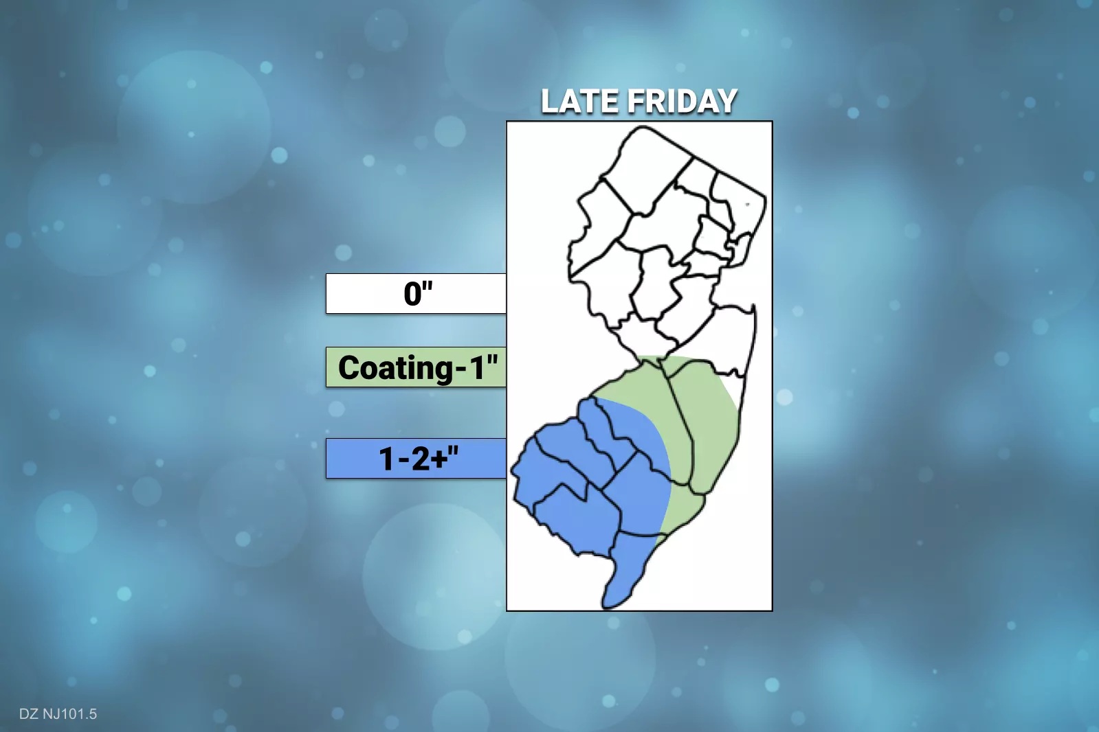
The timing and impacts of late Friday's minor snow event are pretty much locked in — I would call it high confidence at this point. However, there is one big question mark: Will this mini storm system fire up just enough to cause a heavy snow band to form over that "snow zone" of South Jersey? If so, I think snowfall totals could push toward 3 or 4 inches in a few localized areas. (However, to be clear, it seems unlikely that such "moderate" snow accumulations will happen everywhere.)
Saturday & Sunday: Quiet, but Cold
After the snow wraps up Friday evening, clearing skies will resume. And the bulk of the weekend will just be cold.
Expect 20s Saturday morning, and then highs only in the lower 30s Saturday afternoon. Plus, the wind will turn gusty again, over 30 mph at times. That will add a big bite to the cold air.
Sunday looks only slightly better. Sunnier and less windy. But high temperatures only reach the lower to mid 30s.
Clouds will start to fill in late Sunday. But I do not expect our next snow chance to begin until late night.
Monday: Widespread Snow
A clipper system driving west-to-east is expected to drop widespread snow from the Plains to the East Coast early next week. But the jury is still out over what latitude that storm will follow on its journey. Will strong high pressure over Canada push it south, keeping the heaviest snow away from New Jersey? Or will a perfect track allow for a "sweet spot" of heavy snow right over the Garden State?

We just can not answer those questions yet. We know there will be a storm, and it will likely be close enough to New Jersey to produce accumulating snow. Therefore, it will be more impactful and more widespread than Friday evening's mini storm.
However, I can not talk about potential snow accumulations until we get better forecast model consensus.
In Thursday's edition of the CMDZ Weather Blog, I laid out four potential scenarios for early next week's storm system.

To recap:
#1 Total Miss is the most unlikely of the bunch. Max 0" of snow.
#2 Southern Scrape has been the dominant forecast so far this week. Max 3" of snow.
#3 Snow Sweet Spot is also a distinct possibility, if the storm tracks far enough north. Max 6-10" of snow.
#4 Messy Mix also seems unlikely given the breadth of our cold air dome, but it does represent a "too far north" possibility with rain and freezing rain coming into play. Max snow 6-10". Max ice ¼". Max rain ½".
As of this morning, forecast model guidance continues to show a variety of solutions for Monday's wintry weather. (I usually don't like to share the daily play-by-play of models, but I think it is important to understand the uncertainty here.)
—The 00Z GFS went rogue, pushing heavy snow (up to 10") into Central Jersey and an icy mix into South Jersey. This would be in between scenarios #3 and #4, above.
—The 06Z GFS pushes the storm track south again. This would be scenario #3, with snow totals ranging from 1" to the north, to upwards of 10" to the south.
—The 00Z Euro, meanwhile, falls squarely into scenario #2. Just a glancing blow, with something like 3 or 4 inches of snow along NJ's southern edge.
—Both the 00Z Canadian and 00Z ICON (German model) are similar to the 06Z GFS, a scenario #3 "sweet spot" outcome. Snow fans, rejoice.
—Ensemble models are very useful tools in this sort of tight forecast situation. The 00Z GFS ensemble is in between scenario #2 and #3, with 2 to 4 inches of snow for most of the state, and a pocket up to 6 inches to the southwest. The 00Z Euro ensemble follows its operational counterpart, with no more than 4 inches of snow in far southern New Jersey.
The start and end time of this storm are also tricky. It is largely a Monday morning (daytime) event. But snow could creep in as early as late Sunday night. And wintry weather could linger into part of Monday evening.
I have synthesized all that data (and more) to produce the following subjective impacts map for Monday's storm.
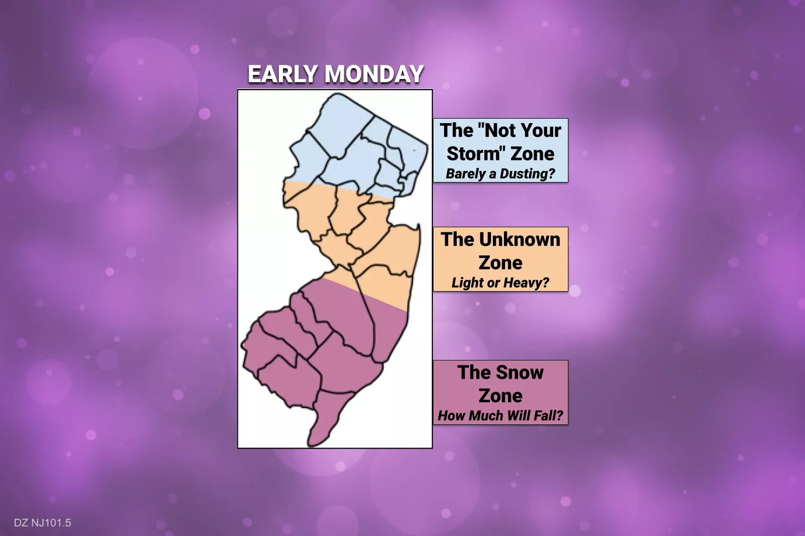
The bottom line: It is going to snow on Monday, centered around the first half of the day. Snow accumulation may be enough to break out the shovels and plows, and possibly call a "snow day" for part of the state. But will NJ max out at 3", 6", or 10" of snow? We are still a day away from hashing out any definitive details.
It will be very important to keep up with forecast changes through the weekend, so you know what to expect on Monday. We will, of course, provide regular updates both on-air and online as the forecast continues to evolve.
The Extended Forecast: Still Cold
Beyond Monday's snow, we settle into a frigid weather pattern through the midpoint of January. High temperatures for most of next week barely reach above the freezing mark. Overnight lows will get colder too, dipping into the teens most nights.
There is still an opportunity for a coastal storm system in our neighborhood late next week, around the Friday-Saturday time frame. Way too early to get a handle on potential impacts yet. Just something else to watch.
Glossary of NJ winter weather words and phrases
Gallery Credit: Dan Zarrow
Dan Zarrow is Chief Meteorologist for Townsquare Media New Jersey. Follow him on Facebook for the latest forecast and realtime weather updates.
How to prepare for winter in NJ: 11 essential gear tips
Gallery Credit: Judi Franco/New Jersey 101.5
More From New Jersey 101.5 FM


