

NJ’s Memorial Day Weekend forecast: More good weather than bad
The Bottom Line
All week long, we have been trying to dial in the details of this holiday weekend forecast. And it's very clear that over the next four days, there will be far more dry hours than wet ones. With some pleasantly warm temperatures along the way. You really can't ask for much more than that here over Memorial Day Weekend.
There are basically four pieces of rain to watch over the next four days — the first three of which should not dramatically interfere with your weekend plans:
1.) A shower may clip southern/coastal New Jersey Friday morning.
2.) Spotty showers and thunderstorms late Saturday night.
3.) Chance of a popup shower or thunderstorm around midday Sunday.
4.) Periods of steady to heavy rain on Monday.
Yeah, Memorial Day Monday is still the snag in this weekend's forecast. Is there an escape route, where we could salvage a dry piece of the day? Yes. But the resounding consensus among model guidance is rain for a mainly wet Monday. No big severe weather threat at least, although downpours and localized flooding could be issues.

Friday
There is one and only one wrinkle in an otherwise fantastic Friday forecast.
A batch of showers is riding along a stalled frontal boundary just south of New Jersey Friday morning. One or two of those showers may clip southern and/or coastal New Jersey at some point. Once we reach the afternoon, dry weather will prevail for all.
Early clouds will give way to mostly sunny skies Friday afternoon. Humidity will continue to dial back as the day goes on, yielding more comfortable air. Temperatures will rise from the 60s in the morning to about 80 to 85 degrees in the afternoon. As a sea breeze kicks in, Jersey Shore beaches will likely top out in the 70s. Nice, nice, nice.
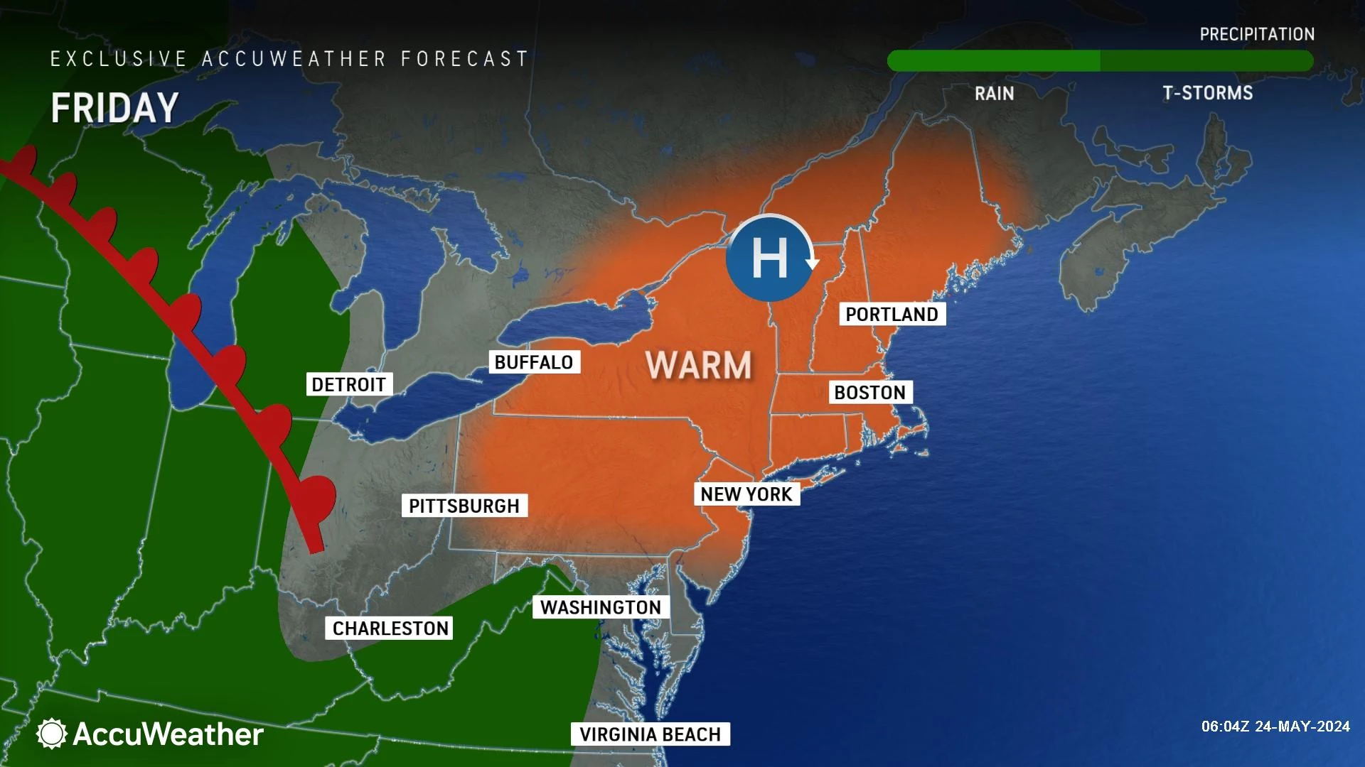
By the way, in today's Jersey Shore Report, we've got calm seas, a low risk of rip currents, and ocean temperatures between 57 and 64 degrees. It's still early in the season, so that ocean water is still pretty cool. But running a couple degrees warmer than normal. So if you're at the beach this weekend, and feel like going for a dip, be my guest. (And remember, we post the latest Jersey Shore Report every morning.)
Friday night stays clear and quiet, with low temperatures around 60 degrees.
Saturday
Saturday begins where Friday left off, with bright skies, warm temperatures, and relatively low humidity levels.
With a mix of sunshine and some clouds overhead, Saturday's high temperatures will reach the lower 80s across most of the state. To the north and along the coast, it will be a bit cooler, likely in the 70s.
There is a chance for some spotty showers and thunderstorms developing. But the most likely opportunity for those raindrops will be late Saturday night — let's say between about 9 p.m. and 3 a.m. Some rumbles of thunder and a quarter-inch of rain are possible in spots.

Sunday
Sunday will feature an uptick in humidity, as dew points return to the 60s. The air will just feel a little stickier. And frankly, more summerlike.

Skies on Sunday will be partly sunny. High temperatures will once again reach the lower 80s for most.
I can not rule out a popup shower or thunderstorm around midday Sunday. The threat for raindrops looks isolated, but it's worth mentioning given the heat and humidity in the air. Don't go canceling your plans prematurely — this is an "eyes on the sky" kind of situation.
Monday (Memorial Day)
Here is the sticky wicket of the holiday weekend. Unfortunately, rain may interfere with many Memorial Day parades and ceremonies.
Forecast models have settled on periods of rain through the morning, afternoon, and early evening hours. Will it pour constantly for the entire day? Not necessarily. But it does look mainly wet.
Possibly stormy too, with some rumbles of thunder and downpours. I could see some localized flooding concerns.
Even if you catch a break in the rain Monday, it will be cloudy and cooler. High temperatures will be limited to the 70s. (Although that is not awful — normal highs for late May are in the mid 70s.)
The Extended Forecast
Tuesday looks good, Wednesday turns wet, and then temperatures slide backward for Thursday.
After this whole week of active weather, I do have to say the extended forecast for the opening days of June looks fantastic. If all goes well, late next week should feature abundant sunshine, dry weather, low humidity, and warm temperatures. A perfect combination, and could be some of the nicest weather days of the entire year.
UPDATED: Memorial Day Parades in New Jersey 2024 (alphabetical)
Gallery Credit: Dan Alexander
Dan Zarrow is Chief Meteorologist for Townsquare Media New Jersey. Follow him on Facebook for the latest forecast and realtime weather updates.
50 Stunning Photos of America Honoring Memorial Day Through The Years
Gallery Credit: Rob Carroll
More From New Jersey 101.5 FM


