

NJ weather: Calm and cool Tuesday, windy and rainy Wednesday
The Bottom Line
The Garden State flips back to the chilly side Tuesday. At least our weather will be calm and bright, with light winds and dry weather.
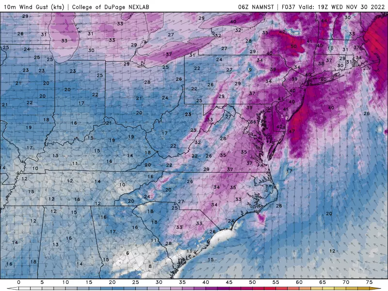
The same can't be said for Wednesday's forecast, as our next weathermaker drives in a not-nice weather day. Yes, it will rain for most of the daytime hours Wednesday. More prominently, some strong winds will mix down to the surface — 40 mph gusts are enough to ring alarm bells.
Following the stormy weather, we'll settle back into sunny, blustery weather for Thursday and Friday. Our next storm system this weekend also looks wet, not wintry.

Tuesday
No weather issues for you, other than the return of a November chill in the air.
Interior New Jersey has frozen overnight, with 20s and 30s on the temperature map to start the day. High temperatures will only reach the mid to upper 40s Wednesday afternoon. That's running about five degrees below normal for late November.
We'll get bright sunshine Tuesday morning, before clouds gradually thicken up through the afternoon. Again, weather will be dry and winds will be light.
With that blanket of clouds overhead, I'm betting that we will not see a freeze for the majority of the state Tuesday night. Low temperatures should average upper 30s by Wednesday morning. Still no rain yet.
Wednesday
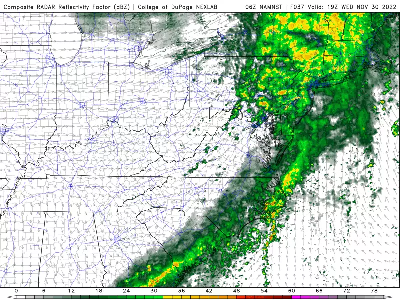
Weather in a word: Inclement. And again, I have to stress that it's not just rain but also wind. Let's run through the details of our next storm system.
—Start Time? Showers are possible Wednesday early morning, especially to the north and west. The main event, with the steadiest rain and strongest winds, will really kick in around mid to late morning. Between about 8 a.m. and 10 a.m.
—How Much Rain? We should average a half-inch of total rainfall across the state. A little more to the north, a little less to the south. Not incredibly heavy, although a brief period of downpours is possible.
—How Much Wind? Top wind gusts will probably exceed 40 mph Wednesday afternoon, especially along the Jersey Shore. (Note: About a mile overhead, winds will be screaming at 60-70 mph — only some of that will mix down to the surface though.)
—Wind Impacts? 40 mph is the threshold for ringing alarm bells for gusty winds. Garbage cans can be blown around. Small branches and trees may come down. And sporadic power outages are possible too.
—Any Other Concerns? Tidal models show a foot of surge is possible, which may cause minor flooding of tidal waterways at high tide. I suspect it will only be a problem for very vulnerable spots along the Jersey Shore.
—Any Wintry Weather? Absolutely not. Temperatures will rise well into the 50s for the duration Wednesday, so it's all rain. Even through temps may drop below freezing late Wednesday night, our weather and ground should be thoroughly dried out by then to prevent a "flash freeze" or significant silppery spots.
—End Time? Rain should taper just after sunset Wednesday, in the 5 p.m. to 8 p.m. time frame. Skies will clear very quickly after that Wednesday evening. Wind gusts will calm a bit overnight, but only a little.
Thursday
December begins with the return of sunny, cold weather. Highs on Thursday will only reach the lower 40s. With a continuing brisk wind, it looks like a "bundle up" day.
Friday
Lighter winds, slightly warmer temperatures, and a continuation of mostly sunny skies. Highs should improve to the upper 40s by Friday afternoon. Still dry too.
The Extended Forecast
Our next storm system is set to arrive on Saturday. I think we are going to see at least some rain fall over New Jersey. But models disagree about whether we're looking at 1.) a quick few hours of steady rain vs. 2.) spotty showers around midday. Once again, temperatures should push into the 50s (at least), so it's wet and not wintry. Skies will be murky and winds will probably increase to the "breezy" range.
Sunday looks like the clearer, although cooler, day of the weekend. Highs will scale back into the 40s again.
And then our next next storm system will come into play next week. Right now, both the GFS and Euro models show a period of precipitation from Monday night into Tuesday. Yet again, lacking an available pool of sustaining cold air, this is going to be a rainy situation. Not snowy. (That pattern may change by the end of next week, by the way.)
Dan Zarrow is Chief Meteorologist for Townsquare Media New Jersey. Follow him on Facebook or Twitter for the latest forecast and realtime weather updates.
Want To Make Sure Your Packages Arrive On Time? Here's Your Deadlines
Gallery Credit: Nicole Murray
A list of NJ malls where you can get photos with Santa for the 2024 holiday season
Gallery Credit: Mike Brant
More From New Jersey 101.5 FM


