

NJ heat wave day 3 of 8: Heat index flirting with 100° Wednesday
The Bottom Line
It seems like the entire Northern Hemisphere is on fire right now. On Tuesday, Mangum, Oklahoma hit 115 degrees in the shade. Meanwhile, the United Kingdom is hitting all-time record high temperatures. London Heathrow hit 104 degrees for the first time ever.
So let's keep our hot weather in perspective — it could be a lot worse.
Having said that, New Jersey will reach "official" heat wave criteria on Wednesday — our third consecutive day of 90+ degree temperatures. Those daily 90s are going to stretch for approximately eight days before we get some relief early next week.
For now, rising humidity will push the heat index closer to the danger zone on Wednesday and especially on Thursday. Sultry, sweltering summer weather. You really have to take care of yourself in this kind of heat.
There is a chance of an isolated thunderstorm on Thursday. But our weather looks primarily bone-dry as we approach what will certainly be one of the hottest weekends of 2022.
Wednesday
70s in the morning, lower to mid 90s in the afternoon. When you factor in rising humidity, the heat index (the "feels like" or "apparent" temperature) will approach 100 degrees. On the edge of dangerous heat.
A Heat Advisory has been issued for 19 of New Jersey's 21 counties — all except Sussex County, Warren County, and the immediate coast. Too much exposure to the heat and humidity could lead to dehydration, heat exhaustion, and/or heat stroke.
In addition, the NJ Department of Environmental Protection has declared Wednesday an Air Quality Alert day for most of the state. Concentrations of ground-level ozone will be elevated, which could lead to breathing difficulties for the very old, the very young, and those with pre-existing lung/heart issues. As if you needed another reason to stay in air conditioning as much as possible.
I am hopeful that the lighter west-southwest breeze will allow the sea breeze machine to fire up Wednesday afternoon. That would keep Shore towns at least a little bit cooler and more comfortable than inland areas.
We'll stay mostly sunny and dry all day Wednesday.
Wednesday evening will stay warm and sticky. Low temperatures will only dip into the mid 70s.
Thursday
One of the worst days of this stretch, as high heat meets high humidity.
High temperatures will soar into the mid 90s. Dew points will peak in the 70s. That puts the heat index in the 100 to 105 degree range for most of the state for most of the day. Yuck.
There will be some passing clouds around. And a prominent southerly breeze will kick up, occasionally pushing over 20 mph. (That will once again make it difficult for a sea breeze to cool the beaches.)
We'll also add a chance for a popup thunderstorm during the daytime hours on Thursday. The atmosphere will be like a soggy sponge, similar to Monday. But lacking a significant spark for thunderstorm development, I don't think thunderstorm activity will be all that widespread. So, watch the sky for an isolated soaker.
Best chance for a quick boomer will be North Jersey around the morning to midday hours. Second-place best chance would be South Jersey around sunset Thursday evening.
Friday
The heat continues, although humidity will roll back slightly for Friday. So it won't be a "dangerous" day — just run-of-the-mill heat.
Blazing sunshine will push high temperatures into the lower 90s. Running about 5 degrees above normal for the hottest time of the year.
Saturday & Sunday
Hands down, this will be one of the hottest weekends of the summer.
Saturday will be sunny and dry. High temperatures in the mid 90s. Humidity looks manageable, so we can leave the dreaded "heat index" out of the discussion for now.
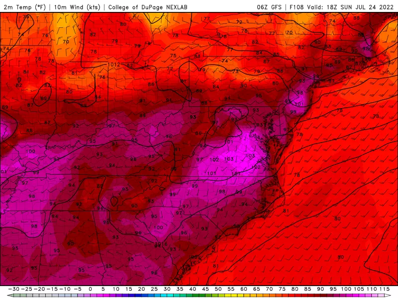
Sunday is trending to be the hottest day of this stretch, with highs reaching the upper 90s to around 100 degrees.
The Extended Forecast
Relief is coming, as a slow-moving cold front slides in sometime between Sunday night and Tuesday morning. The exact timeline of how rain and cooldown will play out is still shaping up.
But I will tell you to keep your expectations in check regarding next week's storm system.
There will be some showers and thunderstorms around. But will it be a healthy, heavy, drought-busting soaker? No.
And we will cool down. But will it feel like crisp, fall weather? No.
I think Tuesday will be our first non-90 degree day, after eight in a row. But we'll still be in the seasonable 80s. The best case scenario would be for a significant reduction in humidity. That would at least allow for a few comfortable days, before heat and humidity surge again heading into August.
Stay cool and stay hydrated out there!
Dan Zarrow is Chief Meteorologist for Townsquare Media New Jersey. Follow him on Facebook or Twitter for the latest forecast and realtime weather updates.
7 Ways to Keep Your Cat Cool When the Weather Heats Up
2022 Seaside Heights Polar Bear Plunge photos
More From New Jersey 101.5 FM


