

Day by day NJ weather forecast for the 4th of July holiday weekend
Happy July, one and all! The big Independence Day weekend is upon us, one of the most important weather forecasts of the year.
This year's holiday weekend is not perfect, with a few rounds of wet, stormy weather anticipated. (Especially on Saturday.) So your beach, boardwalk, barbecue, and fireworks plans may be in trouble.
I wanted to create this simple day by day outline of what to expect, going beyond the standard 5 Day Forecast graphic, so you can plan accordingly. Hopefully this article answers all your questions about impending heat, humidity, and thunderstorms.
Friday: Steamy
Hot and humid, with lots of sweltering sunshine. Breezy at times, blowing out of the southwest up to 20 mph. A few showers or thunderstorms may creep in starting around 4 p.m. Any storms should fizzle by sunset, around 8 or 9 p.m. High temperatures between 90 and 95 degrees for most of the state. The Jersey Shore will end up a little bit cooler, especially on barrier islands.


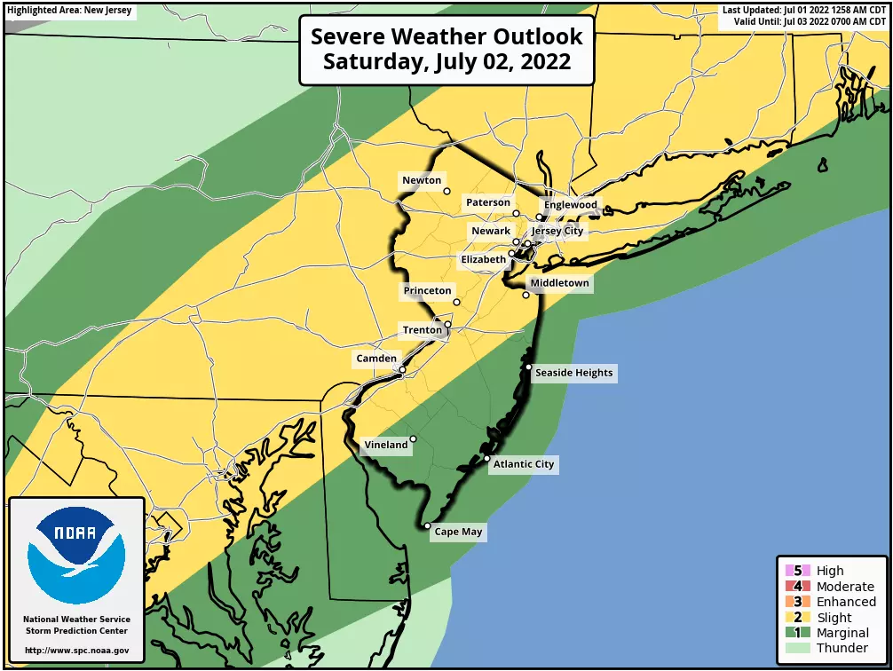
Saturday: Stormy
Expect few showers in the morning, especially across the northern half of the state. It's not a total washout — you will find breaks of dry weather throughout the day, with mostly cloudy skies. Watch the sky for scattered thunderstorms to fire up after 2 p.m. Storms that develop will likely be on the strong side, with heavy downpours and gusty winds. Total rainfall will probably exceed an inch where it really pours. Your outdoor plans for Saturday, including fireworks, are in trouble. It will still be quite steamy, with highs reaching about 85 to 90 degrees.
Sunday: Improving
There may still be some showers around through the morning. But by midday (2 p.m. at the latest), our weather will be drying out and skies will start to clear out. So the afternoon looks good, with emerging sunshine, lowering humidity, and highs in the mid 80s. And Sunday evening looks great — I think our weather will be just fine by fireworks time, although the ground will still be pretty wet.
Monday (4th of July): Great
Easily the nicest all-around day of the weekend. We'll enjoy mostly to partly sunny skies. And a return to relatively low humidity in the air, with dew points only in the 50s. High temperatures will settle somewhere in the lower to mid 80s inland. Probably upper 70s at the Shore. A really nice summer day and summer night.
The Extended Forecast
New Jersey's weather will turn unsettled again on Tuesday, with a few waves of showers and thunderstorms. The raindrops and clouds will probably be enough to cool temperatures into the 70s for the day.
Then the heat is on again. Through the middle to late part of next week, sunshine and 80s should dominate our weather forecast. Maybe with a few popup thunderstorms.
Programming Note
The CMDZ weather blog will be taking a hiatus as I take some much needed vacation time. Our team will still update the 5 Day Forecast and the Jersey Shore Report each morning. I'll be back in the weather center dark n' early on Wednesday 7/6.
I hope you and yours have a safe, fun, relaxing holiday! Happy Birthday, America!
Dan Zarrow is Chief Meteorologist for Townsquare Media New Jersey. Follow him on Facebook or Twitter for the latest forecast and realtime weather updates.
A look at 4th Of July parades happening in NJ for 2022
Gallery Credit: Mike Brant
Simple ways to help your pets cope during fireworks
Gallery Credit: Mike Brant
More From New Jersey 101.5 FM


