
Blizzard Warning: 8 things to know about the NJ ‘snow bomb’
A powerful coastal storm is expected to dump 6+ inches of snow along the Jersey Shore, as 40+ mph wind gusts produce near white-out conditions.
1.) Forecast Update
In accordance with the newest model guidance, I have nudged my "final" forecast snow totals up slightly, pushing the Jersey Shore squarely into the "major snow" category. Overall, this coastal storm is going to be a monster, rapidly intensifying over the ocean as the barometric pressure plummets. While I still have concerns about "over-performance" and even "under-performance" here in New Jersey, all evidence is pointing to a significant snow event for at least the eastern half of the state (and probably more).
In addition to the snowfall, fierce 40 to 50 mph wind gusts will create big visibility, power outage, and wind chill problems both during and after the storm too. Don't underestimate or ignore the wind — it may be just as impactful as the snowfall.
2.) Advisories
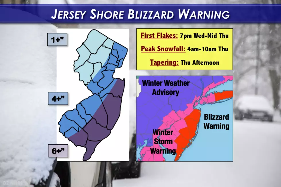
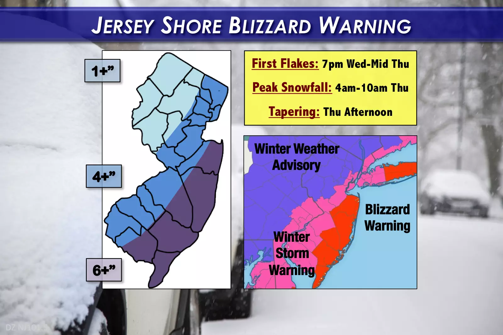
The National Weather Service has posted a Blizzard Warning for New Jersey's coastal counties — Monmouth, Ocean, southeastern Burlington, Atlantic, and Cape May — from 9 p.m. Wednesday through 7 p.m. Thursday.
A Winter Storm Warning has been issued for the NJ Turnpike corridor (approximately) — Hudson, eastern Essex, eastern Union, Middlesex, Mercer, northwestern Burlington, Camden, Gloucester, Salem, and Cumberland counties.
A less-urgent, less-severe Winter Weather Advisory will go into effect at 9 p.m. for the rest of the state — Somerset, Hunterdon, Warren, Morris, Sussex, Passaic, Bergen, western Essex, and western Union counties.
3.) What is a Blizzard?
While a blizzard is widely regarded as the most serious type of winter storm, it actually has nothing to do with how much snow fall. A blizzard requires 1.) Sustained winds or frequent gusts above 35 mph, pushing 2.) visibility below a quarter-mile, for 3.) at least 3 hours.
These conditions are not expected everywhere in New Jersey — that's why the Blizzard Warning is limited to the 5 counties along the Jersey Shore. Near-zero visibility will make travel treacherous (if not impossible) through Thursday morning's commute.
4.) Timeline
--Between 7 p.m. Wednesday and Midnight Thursday... Snow showers arrive in southern New Jersey
--Between Midnight and 4 a.m. Thursday... Snow showers will continue to spread into central and northern New Jersey
--Between 4 a.m. and 10 a.m. Thursday... Prime time... Bands of moderate to heavy snow will combine with a gusty wind to make travel very difficult
--Thursday afternoon and evening (by 7 p.m.)... Snow will taper off from southwest to northeast
--Friday and Saturday... 40+ mph wind gusts will keep things blustery and dangerously cold, with high temperatures only in the teens and wind chills possibly as low as -20
5.) Totals
As we've discussed all week, the Jersey Shore will be the sweet spot for snow accumulation from this storm. My map says 6+ inches — that could realistically go as high as 10+ inches if heavier mesoscale snow bands set up (as I think they will). This is significant snowfall, that will probably cause widespread school closings on Thursday. (If it's any solace, the eastern half of Long Island, New England, and eastern Canada will get hit way harder than New Jersey.)
Further west, the question marks grow even larger. I've got a swath of 4 to 6 inches of snow along the NJ Turnpike corridor, through the 5 boroughs of New York. (Generally in agreement with the NWS Winter Storm Warning, above.) According to my interpretation of the models, this area is most prone to over-performance, especially in South Jersey. In other words, it is wholly possible that one heavy snow band sets up, dumps a few inches in a short period of time, and we end up 7 or 8 inches on the ground. Of course, even the low end of this forecast (4 inches) would lead to slippery roads and low visibility during the Thursday morning rush.
Northwestern New Jersey, this isn't your storm. About 2 inches of snow is forecast for areas north and west of the Turnpike. Enough to cause some travel headaches, but not as significant as your fellow New Jerseyans face closer to the coast.
6.) Coast
NWS has put out a Coastal Flood Advisory, calling for minor tidal flooding due to an extra half-foot to foot of water. (On top of a waning full moon astronomical tide.) I'm still not worried about big surge, big waves, or widespread major issues from the ocean.
However, back bay flooding may become a problem as the strong northwesterly winds push water toward the barrier islands. In addition, that strong land breeze may push a lot of water in the out-to-sea direction, leading to potential low water issues. We'll be closely watching how this develops as the winds increase on Thursday.
7.) Aftermath
Behind the snow will come the return of bitter cold. This arctic blast will be even colder, more ridiculous, more painful, and more dangerous than anything we've seen throughout the extended post-Christmas cold snap.
Both Friday and Saturday will see high temperatures only in the teens, low temperatures potentially below zero, and wind chills way below zero (possibly down to -20 degrees). That absolutely qualifies as dangerous cold with frostbite and hypothermia becoming real dangers after just a few minutes of exposure.
Sunday will be cold too, but winds are expected to finally subside.
Our long-awaited warmup arrives for Monday and Tuesday, with high temperatures popping into the 40s!
8.) Final Thoughts
Throughout this week, I've described this coastal storm forecast as precarious, volatile, delicate, and tricky. And it still is! The two biggest variables — storm track, and mesoscale snow bands — may royally screw up this forecast in the end.
Hopefully you can adjust your plans to avoid traveling during the worst of the storm Thursday morning, allowing crews to clear roads as quickly as the weather allows. Realizing that not everyone can do that, please exercise an enormous amount of common sense and good judgment. Even though we're still technically getting just a glancing blow, it's pretty clear that this storm will deliver serious winter weather impacts to the Garden State throughout Thursday.
We'll be on-air and online starting at 5 a.m. Thursday with full news, weather, traffic, and talk coverage of this potential blizzard. Next weather blog is scheduled to be published by 7 a.m. Thursday.
Be smart and be safe, New Jersey!
Dan Zarrow is Chief Meteorologist for Townsquare Media New Jersey. Follow him on Facebook or Twitter for the latest forecast and realtime weather updates.
More From New Jersey 101.5 FM


