
An active, stormy day for NJ: Wind, flooding, hail, and tornadoes possible
The Bottom Line
Thursday is going to be an active, occasionally stormy day. A warm front will increase humidity and instability across New Jersey. And so the risk for severe weather - damaging wind, flooding rain, large hail, and even a few tornadoes - is elevated. While storms are not guaranteed for everyone in New Jersey, the worst-case scenario is quite concerning.
A late-night cold front will put an end to the storms, and bring in delightfully dry air for both Friday and Saturday. It's going to feel September-ish.
Our next rain chance will come on Sunday, to kick off the month of August.
Thursday: Storm Timeline
Usually, this is the point where I launch into a detailed timeline of what to expect on this day. However, this is not only an active forecast, it's also a dynamic one. So it's difficult to pinpoint. For each of the next ~18 hours, it could be raining/storming somewhere in New Jersey. Conditions are subject to change dramatically as the day goes on. And the strength and spread of each round of thunderstorms will depend largely on how the previous ones behaved.

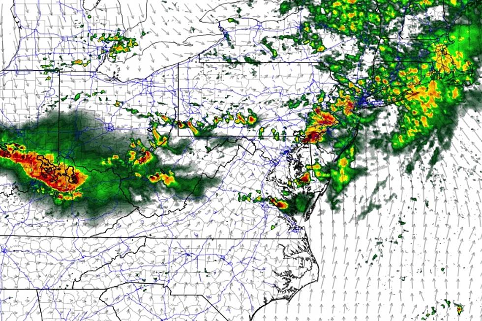
As of this writing (5:30 a.m.), we already have a cluster of showers in South Jersey. These seem to be air mass based, not really associated with our "main event". But it is indicative of our overall unsettled day. They're moving slowly, and there are some pockets of heavy rain that may affect your morning commute. Primarily along and south of the AC Expressway.
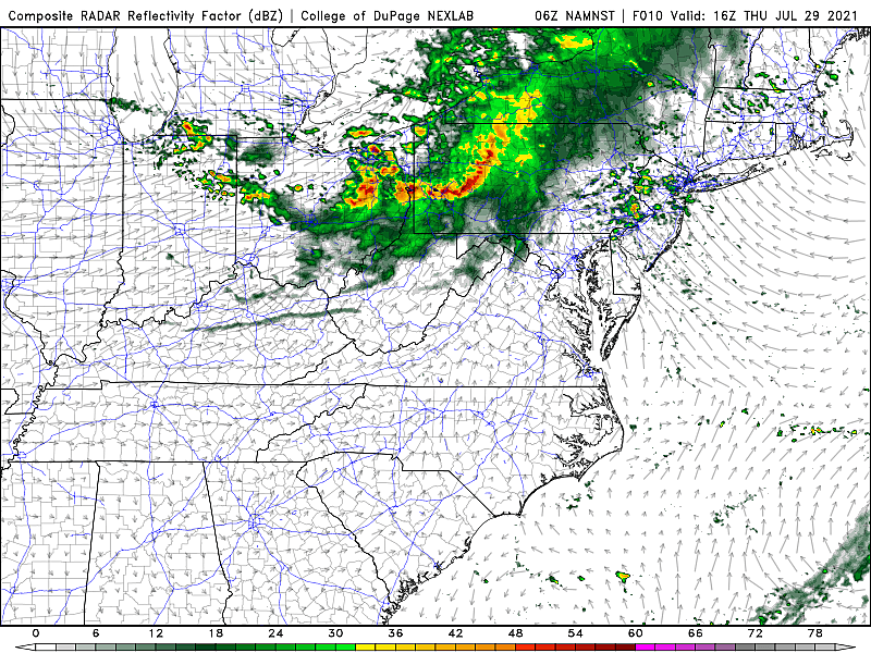
As a warm front lifts through New Jersey around mid-morning Thursday, spotty to scattered thunderstorms will envelop the state through the afternoon.
It's not going to rain that entire time - in between raindrops, it will be mostly cloudy with high temperatures in the upper 70s to around 80.
Needless to say, it will not be a good beach day at the Jersey Shore.
Now here's the thing. If we see peeks of sun at any point Thursday. If temperatures push past 80 degrees. If dew points spike into the 70s (as expected). Then the atmosphere is going to cook. And later storms are more likely to reach strong or severe limits.
I'll even go so far as to say the late afternoon-evening "grand finale" round of thunderstorms is not a guarantee. (The GFS model, for one, paints a much drier, calmer picture than the rest.)
It looks like storm activity will pulse down and exit the state by around midnight Thursday night. Skies will then start to clear, as drier air trickles in from the northwest. Overnight low temperatures will be almost comfortable, in the upper 60s to around 70.
Thursday: Storm Impacts
Let's examine each of the five primary thunderstorm impacts. Specifically how likely and severe they will be.
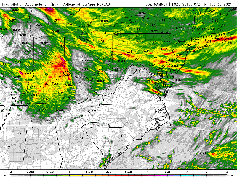
Rain... Practically guaranteed for the entire state. Model guidance suggests most rainfall totals will end up in the quarter-inch to half-inch range. The problem is if a storm stalled (gets stuck) or trains (constantly forms and re-forms over one area), a few spots could get drenched. Don't be surprised to see localized 3+ inch totals, which is more than enough to cause ponding and flash flooding issues.
Lightning... Also guaranteed. By definition, every thunderstorm contains lightning (and thunder). And therefore, by definition, every thunderstorm is potentially dangerous. There will be sufficient instability in the atmosphere to spark lightning. I'm not sure if I would call the threat "frequent" or "wicked' this time around, but it could get bright and loud within Thursday's storms.
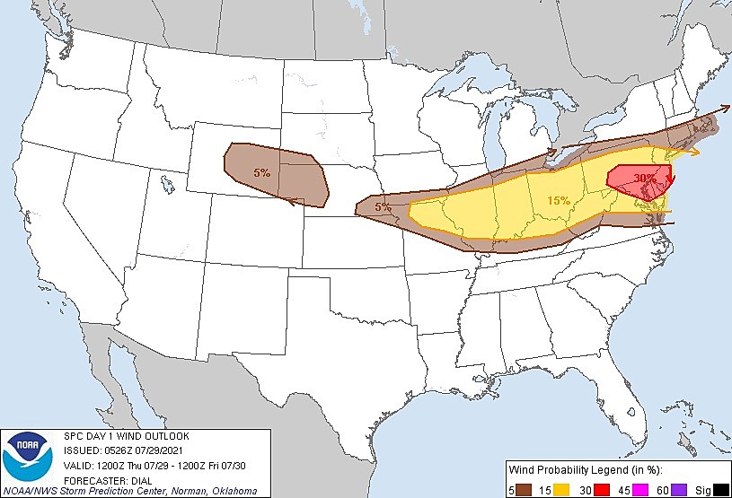
Wind... The top severe threat. In fact, the Storm Prediction Center has painted NJ in a 30% severe wind risk, in the "Enhanced" category. That doesn't happen very often here. Any of Thursday's thunderstorms - morning, afternoon, or evening - could push out some 40 to 60+ mph wind gusts. The danger is especially great if that late afternoon-evening round of storms comes to fruition. (Some of the mesoscale models paint a clear "bow echo" signature of those strong thunderstorms.) Downed trees and power lines could make a mess through Thursday night.
Hail... As we've seen several times this summer, hail is possible from Thursday's storms. As strong updrafts keep a condensation nuclei in the cold upper reaches of a cumulonimbus, chunks of ice form. Eventually, those hailstones are heavy enough to fall to the ground. So only very strong, tall thunderstorms can cause hail. (Especially large hail - quarter-size or bigger.) I believe these storms will qualify.
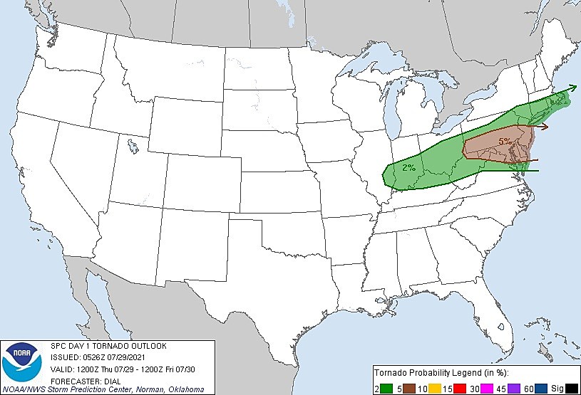
Tornadoes... All it will take is a little twisting action, a little shear, and you get a tornado. The Storm Prediction Center puts NJ in a 5% tornado risk - that's huge for the Northeast US. THe parameters aren't perfect. But the atmosphere will certainly be conducive to quick spin-ups.
Thursday: Action Steps
Be vigilant. Stay alert. Use common sense.
By reading this forecast, you're already ahead of the game - you know there's a thunderstorm threat. This isn't the first time New Jersey faces strong summertime storms. And, of course, it won't be the last.
Outdoor activities are in trouble Thursday, but not impossible. You'll just have to keep an eye on ear on the sky. If you see dark clouds and/or hear thunder, it's time to hear inside.
You may want to keep your cell phone topped off on the charger, in case there is a power outage in your area at some point. And secure your garbage cans, lawn furniture, toys, etc.
If a warning is issued for your area, seek shelter in a sturdy building immediately. Never attempt to drive, walk, or swim through flooded areas.
Friday
Throughout the day Friday, dew points will descend from about 65 to 45. That is some ridiculously dry air for the middle of summer!
We'll keep a refreshing 20+ mph breeze out of the northwest all day too.
But it's not going to be a cold wind, just drier. High temperatures should still reach into the lower to mid 80s.
Saturday
Expect a September-ish feel to the air. Morning lows will easily dip into the 50s across the state. I fully expect some 40s in NW NJ.
Saturday's high temperatures will be limited to the upper 70s to lower 80s. Anywhere from 5 to 10 degrees below normal for the last day of July. So not "cold" at all. Especially given the bright sunshine overhead, I think you'll still be clear to enjoy the beach or pool.
Humidity will stay in the basement for one more day. And winds will be lighter than on Friday.
Sunday
Our next chance of rain looks to arrive on Sunday, which is the first day of August. But the forecast is looking a little drier. Rather than a period of steady rain, I think we'll only see a few showers and thunderstorms. And there's a good chance that parts of New Jersey squeeze out a dry day. (Especially to the south.)
Temperatures will be more summer-ish, returning to the lower to mid 80s. And dew points return to "the sticky zone" in the 60s too.
The Extended Forecast
A weak cold front will once again dry out the air for Monday. There could be an early morning shower, then skies should clear to sunshine. High temperatures in the lower 80s will make for another pleasant day.
However, I'm not liking the signal showing up in the long-range forecast for the middle to late part of next week. No extreme heat - actually the opposite, with temperatures at or below normal. That's because of a potential stalled front, providing a highway for persistent waves of rain.
There's a chance that rain misses us to the south, leading to continuing delightful weather. If not, next week's forecast will be pretty unsettled and quite soggy.
Dan Zarrow is Chief Meteorologist for Townsquare Media New Jersey. Follow him on Facebook or Twitter for the latest forecast and realtime weather updates.
BEEP BEEP BEEP: These are the 13 types of Wireless Emergency Alerts auto-pushed to your phone
Gallery Credit: Dan Zarrow
13 things to love about Six Flags Great Adventure's new Jersey Devil roller coaster
Gallery Credit: Dan Zarrow
More From New Jersey 101.5 FM


