

Up to 8″ snow and single-digit temps: Latest NJ weather update
UPDATE... This article is outdated...
For the latest storm forecast information, please refer to my newest weather blog post.
UPDATE as of 5:30 p.m. Saturday...
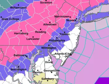
A WINTER STORM WARNING (pink) has been issued for all or part of 8 counties in North Jersey, in effect Sunday midday through Sunday night. That is the most likely area to see over a half-foot of snow.
A less-urgent, less-severe Winter Weather Advisory (purple) covers an additional 8 counties in NJ tomorrow. That is the area most likely to see at least 2 or 3 inches of accumulation.
As the certainty of a period of snowy weather and sloppy travel becomes more certain, it's time to prepare accordingly. Maybe that means stocking up on some food and supplies. Maybe that means dragging your shovels and salt out of the shed. Maybe that means changing plans for tomorrow afternoon or evening. Maybe that means nothing at all.
Here are the details of the warning and advisory from the National Weather Service:
Winter Storm Warning:
—10am Sunday to 1am Monday... Hunterdon, Morris, Sussex, and Warren counties.
—1pm Sunday to 4am Monday... western Bergen, western Essex, Passaic, and western Union counties.
Winter Weather Advisory:
—7am Sunday to 1am Monday... northwestern Burlington, Camden, Gloucester, and Salem counties.
—10am Sunday to 1am Monday... Mercer, Middlesex, and Somerset counties.
—1pm Sunday to 4am Monday... eastern Bergen, eastern Essex, Hudson, and eastern Union counties.
No Warnings or Advisories:
—Atlantic, southeastern Burlington, Cape May, Cumberland, Monmouth, and Ocean counties.
Next full forecast update is planned for early Sunday morning, just before snow begins for most of New Jersey.
ORIGINAL POST from 10:20 a.m. Saturday...
The Bottom Line
There are three big weather headlines to talk about between now and next week:
1.) Mild temperatures and spotty rain showers on Saturday.
2.) Accumulating snow for most of New Jersey on Sunday.
3.) Bitter cold and dangerous wind chills next week
Let's jump right into the latest details, so you can plan ahead and stay safe and warm.
Saturday: Mild with Showers
We might actually hit 50 degrees in South Jersey on Saturday, a feat not seen since New Year's Day. Most of the state will soar well into the 40s, despite mostly cloudy skies. It has been a welcome break from an unusually cold stretch throughout mid-January.
In addition, a weak wave riding through the atmosphere will spark some showers between the midday and afternoon hours on Saturday. These are almost exclusively rain showers - spotty and light, and only a minor damp nuisance.
There is a very limited opportunity for some wintry mix around colder higher elevation areas in Sussex and Warren counties — if showers even push through that corner of the state. Little to no accumulation is expected, just watch for slippery spots.
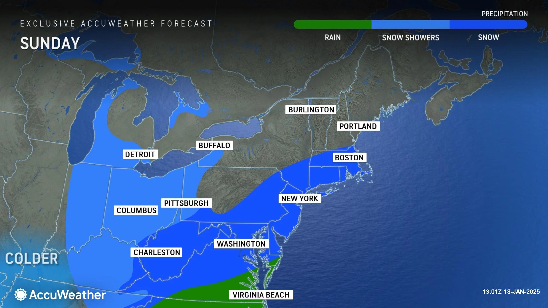
Sunday: The Latest Thinking
There are still two distinct scenarios in play across our full suite of forecast models:
1.) A farther-away, colder storm track that would allow for light snow across all of New Jersey.
2.) A closer, stronger storm track that would lead to heavy snow bands in North Jersey and substantial mixing along the South Jersey coast.
As we have discussed, the biggest factor here — and the biggest hindrance in nailing down snow totals and storm impacts — is our upcoming intrusion of really cold air. That will have a direct impact on storm track, snow ratios, etc.
I have a much better handle on how things are shaping up, compared to 24 hours ago. So forecast confidence is definitely on the rise. I am happy to present here a realistic forecast, an honest assessment of how I see things playing out. My usual "gut check" benchmark applies: I think there are equal chances of having to raise and lower the snow total forecast.
Keep in mind, with more than 24 hours to go until first snowflakes, things can absolutely still "wiggle" and change a bit. Could that "snow zone" of North Jersey ultimately end up higher at 6-10" or even 8-12"? Sure. Could South Jersey turn into even more of a dud, with little to no accumulation? Sure. Or vice versa. Expect additional updates later Saturday and again Sunday morning.

Sunday: Timeline
Early Sunday morning looks OK. Colder air will be returning to New Jersey, so temperatures will only reach the 30s. For the "snow zone" of North Jersey, thermometers should be right around the freezing mark at storm onset — perfect conditions for accumulating snow.
By late Sunday morning (10 a.m.), we will be looking for first snowflakes to push into southwestern New Jersey. Initial precipitation bands will spread north and east through the early afternoon (2 p.m.)
The brunt of the storm, with the heaviest and most widespread snow, will be from Sunday late afternoon through early evening. Let's say 4 p.m. to 8 p.m. Dinnertime hours. (And right in the middle of the Eagles-Rams football game.)
Snowfall should wind down quickly Sunday evening, likely ending completely by 10 or 11 p.m. Arctic air will "whoosh" in on a gusty wind, making for quite a wintry night.
Treated and plowed major roads will probably be in decent shape by Monday morning's commute. (Keep in mind, Monday is the Martin Luther King Jr Day holiday.) But there could be some residual tricky spots for sure.
Sunday: Accumulations
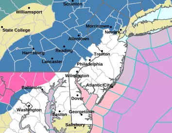
Given the latest storm track and temperature forecast, this probably will not be an "all snow" situation for New Jersey. Above-freezing temps to the south and east will allow for a mix of wet snowflakes, sleet, and rain for at least the first part of this storm. (A flip to all-snow may happen as sunset coincides with the heaviest precipitation.) All in all, it is especially tricky to nail down accumulations and impacts for southern and coastal areas.
I have settled on a forecast of 4 to 8 inches of snow accumulation for most of northern New Jersey. There is an opportunity for overperformance, if very heavy snow bands set up, with localized totals possibly exceeding 10 inches. I think that is the exception, not the rule. This area of the state will contend with an influx of very cold, very dry air. That may "shut off" the snow machine to an extent. And it will lead to a very dry, powdery snow, given the high snow-to-water ratio.
The NJ Turnpike corridor is expected to end up in the middle of the heavy snow and mixing zones. I think you will still see some good accumulation in this stripe of the state, on the order of 2 to 4 inches. But the best chance for heavy mesoscale snow bands will stay to your north and west.
To the south and east, rain and sleet will likely mix with snow for a time. (As the map shows, this is especially true the closer you get to the immediate coast.) Still, a late transition to all snow could allow for 1 to 2 inches of accumulation. Again, you will miss out on the heaviest precipitation bands.
South and coast, after being the "snow bullseye" for the last two winter storms, you get a break this time around. It is going to be wet and slushy. There could still be some snow and sleet around, and minor travel issues. Total accumulation up to 1 inch is possible. But really, this ain't your storm.
Sunday: Impacts & Advisories
For winter storms, obviously travel conditions are the biggest impact. There will be a period of challenging travel due to poor visibility and icy, slushy roads. It is important to note this is not a outright "blizzard" — we are not talking about giant drifts and whiteout conditions. And it is not a "bread and milk" storm — you are not going to be stranded in your house for days here.
Strong winds are not expected during the storm, although gusts will kick up afterwards. Widespread power outages seem unlikely. Coastal flooding is not expected to be a problem either, although up to a foot of storm surge is possible.
A Winter Storm Watch has been issued for 8 NJ counties in advance of Sunday's storm: Bergen, western Essex, Hunterdon, Morris, Passaic, Sussex, western Union, and Warren. This is the area of the state most likely to reach watch/warning criteria of 6+ inches of snow accumulation.
If the forecast holds, the watch will likely be upgraded to a warning either Saturday afternoon or Sunday morning. At that time, advisories will likely be issued for any area of the state expected to see at least 2 to 3 inches of accumulation. That will be your signal to complete any pre-storm preparations, check your supplies, and consider your Sunday/Monday plans carefully.
Next Week: Bitter Cold
The other big weather story is the upcoming intrusion of really cold arctic air. Cold enough to send wind chills into the subzero "dangerous cold" zone. Next week could be New Jersey's most frigid stretch of weather in at least seven years.
For several days in a row — Monday, Tuesday, and Wednesday, at least — morning lows may dip into the single-digits, with wind chills potentially below zero. That is cold enough for frostbite and hypothermia to set in within a half-hour — that is why we call it "dangerous" cold.
High temperatures will get stuck between about 15 and 20 degrees most days. Again, with a biting wind chill, likely keeping those "feels like" temperatures at or below 10.
New Jersey could very well see its first-ever Cold Weather Advisory, a product that was just launched by the National Weather Service this season as a consolidation of several other now-retired advisories.
I am also worried about the flash freeze potential, especially along NJ's southern coast area that will see mainly rain/mix on Sunday. Anything wet will freeze, leading to persistent slippery spots.
Extreme cold can also lead to serious infrastructure difficulties, like water main breaks and power outages. Your car is probably going to need some serious warm-up time too.
Bottom line: Welcome to the dead of winter, New Jersey! Stay smart, be safe, and keep warm out there.
Glossary of NJ winter weather words and phrases
Gallery Credit: Dan Zarrow
Dan Zarrow is Chief Meteorologist for Townsquare Media New Jersey. Follow him on Facebook for the latest forecast and realtime weather updates.
Let it snow: 12 things to know about winter forecasting in NJ
Gallery Credit: Dan Zarrow
More From New Jersey 101.5 FM


