Two flavors of spring weather for NJ this week: Nice, then wet
The Bottom Line
Happy last day of April! This month's weather was tumultuous, starting wet and miserably cool and then drying out and warming up.
As we prepare to dive into May, we do have more pleasant weather ahead — although Wednesday and Thursday will not be as warm and summery as Tuesday.
However, pollen levels remain high, fire danger is elevated, and drought concerns continue.
Yes, we still need rain. But yet again, it is going to coincide with part of the weekend. Don't go cancelling your Friday or Saturday plans just yet, but you might start thinking about a "Plan B". And keep a close eye on the forecast.

Wednesday
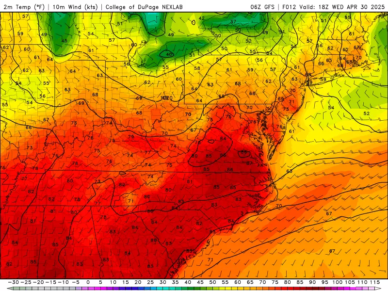
Unlike the past several mornings, you probably do not need a jacket or sweater to start the day — temperatures are in the 60s across the state.
In addition, a cluster of rain did not completely fizzle out over Pennsylvania. So anyone in the state could see a quick shower through about 9 a.m. Wednesday.
That is the one wrinkle in Wednesday's forecast, as the rest of the day trends pleasant and dry.

Early clouds and a stiff breeze will give way to sunshine Wednesday afternoon. Humidity will lower as the day goes on.
High temperatures will mainly reach 70 to 75 degrees Wednesday afternoon. A bit cooler than Tuesday's 80-degree temps, but still above normal for this time of year. North Jersey will be held a bit cooler, likely in the 60s through the afternoon.
Wednesday night will be quiet, with just a few clouds overhead. But we will be back to chilly "jacket weather" with lows averaging upper 40s across the state.
Thursday
Overall, a nice day. It will be a classic "partly sunny" situation, as sun mixes with thin clouds overhead.

Temperatures will end up on either side of 70 degrees. Realistically, that will be closer to 65 degrees to the north and along the coast, with an on-shore breeze developing. Inland NJ will probably surge to near 75.
Friday
We will get another taste of summertime weather on Friday, as temperatures heat up and humidity rises again.
Look for high temperatures in the lower 80s for most of the state, with sun and clouds. Dew points well into the 60s will keep you sweating too.
A shower or thunderstorm is possible at any time Friday. Isolated, but potentially potent given the abundant heat and moisture in the air. At this point, I would say the best chance for raindrops would be early and late.

Saturday
As a more substantial impulse rides into New Jersey's atmosphere starting Saturday morning, a period of steady rain looks likely once again.
For now, I will say that your best shot at dry weather on Saturday will be at the beginning and end of the day. Pockets of heavy rain are possible through the middle of the day, with about a half-inch of rain.

Even when it's not raining, Saturday will be cloudy and breezy and cooler. The high temperatures for the day will happen in the morning, in the upper 60s. By late afternoon, thermometers will likely be closer to 60 degrees.
Sunday & Beyond
The biggest question mark in the forecast is what happens on Sunday. Until now, the prevailing forecast calls for drying out and clearing out, with the return of sunshine and seasonable temperatures.
However, latest model guidance now shows low pressure redeveloping just off our coastling on Sunday and potentially lingering through the first half of next week.
The end result of that? Several days of miserable, persistently rainy weather. We're talking Sunday, Monday, Tuesday, and Wednesday.
This morning's European model even shows a worst-case scenario — 4 to 8 inches of total rainfall over the next week. For the record, it is hard to imagine such a scenario playing out. Especially since "dry" is also still on the table. But that should would do wonders for NJ's drought and wildfire situation.
We should have better clarity and details on the rainfall timing and magnitude in the next day or two.
Cough, cough: NJ's favorite lost voice and sore throat remedies
Gallery Credit: Dan Zarrow
Dan Zarrow is Chief Meteorologist for Townsquare Media New Jersey. Follow him on Facebook for the latest forecast and realtime weather updates.
Road trip! The hottest theme parks in the Six Flags-Cedar Fair family
Gallery Credit: Dan Zarrow
More From New Jersey 101.5 FM