
Turbulent weather Thursday for NJ: Stormy, windy, then colder
UPDATE as of Noon Thursday...
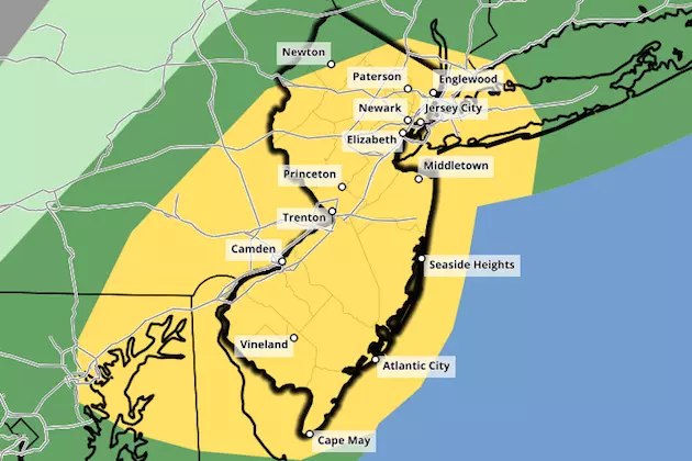
A Severe Thunderstorm Watch has been issued for 19 of NJ's 21 counties (all but Sussex and Warren) until 4 p.m. Thursday.
A watch serves as a formal heads up that dangerous weather is likely to occur. This includes the threat for damaging winds, small hail, and even an isolated tornado. Heavy downpours and frequent lightning are also likely.
These storms are going to pack quite a punch. You'll want to stay inside a sturdy building as they pass.
ORIGINAL POST from 6:06 a.m. Thursday...
It is going to be an active weather day for New Jersey, as a strong cold front puts an end to the spring-tactic 60s and 70s we've enjoyed lately. As my headline suggests, we can break down this turbulent transition into three distinct parts: 1.) Rainy and stormy, 2.) Windy, and 3.) Colder.
Radar is starting to light up to the west of New Jersey. And we'll see scattered rain slide in by Thursday mid-morning. This is all ahead of the aforementioned cold front. The front itself — that's the leading edge of the cooler air mass — will arrive around Thursday midday, leading to a round of strong to severe thunderstorms. Our biggest concerns here are heavy downpours and damaging winds. Frequent lightning is likely. Small hail is possible. And an isolated tornado spin-up can't be ruled out.
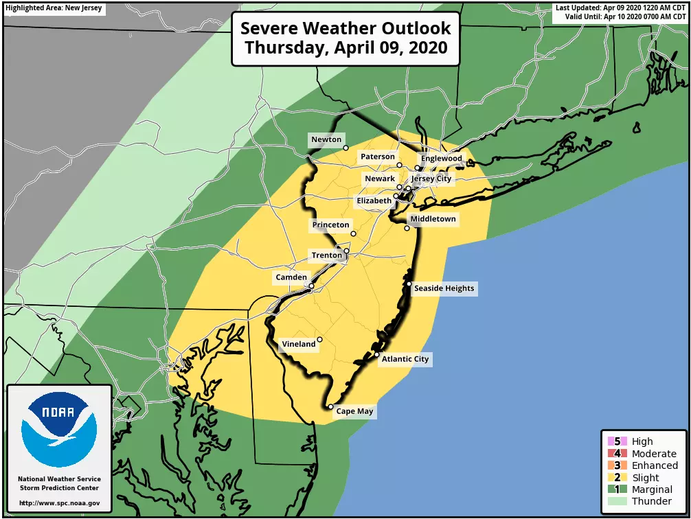
I would not be surprised at all to see a Severe Thunderstorm Watch issues for the state later this morning. If you are outside for any reason, stay "weather aware" and keep an eye on the sky as those storms approach.
Behind the front, our new cooler air mass will arrive with a whoosh of wind. Westerly wind gusts of 40 to 50 mph are expected. That's strong enough to cause minor damage, bring down branches, cause sporadic power outages, blow around garbage cans, and make driving difficult. A Wind Advisory has been issued for all of New Jersey from early afternoon through early evening. (And may be extended depending on how the wind speed is trending.)
High temperatures on Thursday will range from the mid 50s (north) to around 70 (southwest). Thermometer will peak just before the storms hit, then tumble through the afternoon hours.
And Thursday night is going to get pretty cold! Low temps will mainly dip into the upper 30s — it hasn't been that cold in about a week. Furthermore, it's going to feel blustery thanks to that biting wind. My calculations put the wind chill ("feels like" or "apparent" temperature) around 30 degrees by Friday morning.
Models also show a few stray showers around overnight.
The brisk wind will continue for Friday, with regular gusts between 30 and 40 mph. That's just below the official "advisory" criteria — but you'll definitely still notice it. We'll see periods of sunshine and clouds overhead. Long gone are the lovely 60s and 70s — Friday afternoon's high temperature will only reach about 50 degrees.
Our forecast fares better through the rest of the holiday weekend. Saturday looks bright and sunny! It will be breezy and dry, with highs improving to the mid 50s.
For Easter Sunday, we'll transition from sun to clouds as temperatures warm into the lower to mid 60s. Nice day, although our next storm system will loom closer and closer. It looks like the threat of rain will hold off until Sunday night.
Early Monday morning looks very wet, with a period of heavy rain. Monday afternoon, on the other hand, is forecast to be windy and warm. There is resounding model consensus showing widespread 70s on Monday, before another cooldown arrives on Tuesday.
Lots of turbulent, inclement weather going on today. Be safe out there!
Dan Zarrow is Chief Meteorologist for Townsquare Media New Jersey. Follow him on Facebook or Twitter for the latest forecast and realtime weather updates.
More From New Jersey 101.5 FM


