

Tropical Storm Watch dropped for NJ as Jose prepares to pass by
Tropical Storm Watch dropped for NJ as Jose looms closer
Moderate surf, storm surge, and coastal flooding impacts are still expected along the Jersey Shore.
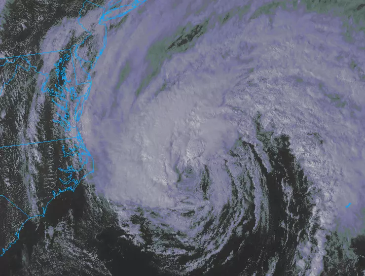
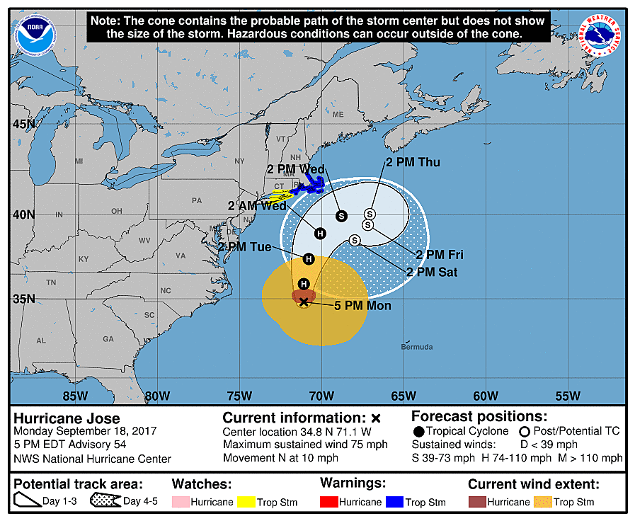
The "blanket" Tropical Storm Watch that included the Jersey Shore yesterday? Gone! The threat for sustained 39+ mph winds for New Jersey always seemed a bit of a stretch to me. And the National Hurricane Center has now focused its attention on the New England coast, set to receive the fiercest impacts from Hurricane Jose.
Important note: The cancellation of this watch does not mean the forecast and/or expected conditions have changed. By definition, the NHC had to either drop it or upgrade it, and they chose the latter based on the marginal-at-best forecast for tropical storm force winds.
As the center of Jose passes 200 miles east of New Jersey, we will absolutely feel some weather and surf impacts. Tuesday is just going to be a "yucky" day overall, especially along the Jersey Shore.
TIMING: Conditions will go downhill Monday night, peaking on Tuesday, and subsiding by Wednesday morning.
RAIN: The threat is marginal, and depends wholly on the location and intensity of any rain bands that set up in our area. The potential exists for 1 to 3 inches of rainfall. But don't be surprised if part or much of NJ stays completely dry for the duration.
WIND: Breezy to gusty, with sustained winds 15 to 30 mph and gusts over 50 mph possible.
OCEAN: 10-foot waves will batter beaches and potentially cause significant erosion. 1 to 3 feet of storm surge will cause "minor" to "moderate" coastal flooding at high tide.
Again, we are lucky enough to say this is not a direct hit - Jose's "brunt" will stay well east of us. In terms of preparation, most New Jerseyans will only need to secure garbage cans and patio furniture, prepare for sporadic power outages, and obey road closures due to flooding and debris.
My usual advice: Be smart, be safe.
Our weather, news, and traffic teams will continue to track Jose until the final raindrops fall, the final wind blows, and the final wave crashes ashore. Unless the forecast changes drastically or conditions go downhill unexpectedly, my next weather blog post is scheduled for Tuesday morning by 7 a.m.
Dan Zarrow is Chief Meteorologist for Townsquare Media New Jersey. Follow him on Facebook or Twitter for the latest forecast and realtime weather updates.
More From New Jersey 101.5 FM


