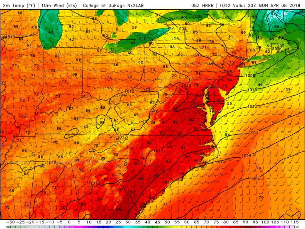
Temperatures really get cooking Monday: Could NJ hit 80 degrees?
What a superb spring weekend, huh? Most of New Jersey basked in above-normal near-70 temperatures and bright sunshine through most of the weekend. Of course, if you were on a barrier island surrounded by chilly water, you still needed a jacket with temps only in the 40s and 50s. Typical springtime pattern.
We had some moderate to heavy rain pass through the Garden State overnight, which have tapered to stray showers and sprinkles as of this writing. Just watch out for wet roads.
Monday is shaping up to be a breezy and warm start to the workweek. And since that wind — with gusts over 20 mph — will come from the west, even the coast will enjoy a taste of warm air.
Temperatures for Monday morning are starting out in the 50s. We'll make a run for widespread 70s for Monday afternoon. And answer the question I posed in the headline of this post... Yes, 80 degrees is a legitimate possibility somewhere in New Jersey!
Another round of showers is expected Monday evening, especially for the southern half of the state. Despite the warmth (energy) and humidity (moisture), I don't expect anything too strong — just don't be surprised if you hear a rumble of thunder.
The rest of Monday night will be mostly cloudy and relatively warm, with lows only dipping into the 50s once again.
Tuesday's forecast is tricky. If not impossible. There are pretty much two scenarios that could play out:
1.) Continued warmth, with another day of widespread 70s.
2.) A backdoor cold front drags in marine-influenced air, cooling down part of New Jersey.
It's the kind of forecast that gives me a headache, because there's just no way to pinpoint exactly where (or even if) that cooler air will end up. I'm leaning mostly toward scenario #2. Areas to the north and east will get stuck around 55 degrees. Southwestern New Jersey will probably top out around 75 degrees.
Regardless of where temperatures end up Tuesday afternoon, I think clouds will win the sky. And a round of showers is likely from Tuesday late afternoon through Tuesday early evening, as a "regular" cold front traverses New Jersey.
So Wednesday will definitely be a cool day for the entire state. Highs will be limited to the mid 50s, about 5 degrees below-normal for early-to-mid April. Skies will be mostly to partly sunny, and the weather looks dry. Not bad.
About the same for Thursday, with upper 50s and increasing clouds. The warming trend will continue on Friday, with highs popping into the lower to mid 60s.
Our next storm system arrives late Friday, as another cold front drives yet another band of rain through NJ.
I'm admittedly hesitant to go into too much detail about the medium-range forecast, given the low confidence in the short-range. That front doesn't seem to have an immediate impact on temps, as I'm still seeing 60s for Saturday. For now, it looks like Sunday will be influenced by a prominent on-shore wind, keeping temperatures cooler (50s) and enhancing a chance of late-day rain.
Dan Zarrow is Chief Meteorologist for Townsquare Media New Jersey. Follow him on Facebook or Twitter for the latest forecast and realtime weather updates.
More From New Jersey 101.5 FM


