
Snow! Here comes NJ’s first accumulation of the season
This forecast has evolved significantly over the past day — the start of the weekend now looks snowy and cold.
UPDATE as of 10 a.m. Friday...
Original Post from 6 a.m. Friday...
There is now overwhelming evidence among all forecast models that the track of our impending coastal storm system has shifted further west — in other words, closer to the Jersey Shore. Therefore, we have ramped up snowfall expectations a notch. The timing of the heaviest snow has also shifted a bit later — this is now mostly a "Saturday" weather event, rather than a "Friday night to early Saturday" event.
I hereby retract my previous statements that this system would produce only "conversational snow," and that no travel issues are to be expected. You may very well find some challenging driving conditions Friday night and Saturday due to reduced visibility and traction.
Temperatures

One fact that hasn't changed — the atmosphere is definitely cold enough to sustain snow. Highs on Friday will be limited to the lower 40s — about 5 degrees cooler than Thursday, and 5 degrees below normal for early December. Overnight lows will dip into the 20s across almost the entire state. Saturday's high temps will only reach the lower to mid 30s.
Thermometers will top out around 40 degrees for Sunday, in the lower 40s for Monday, and in the mid 40s on Tuesday. And then another arctic blast knocks back temperatures even further. High temps for midweek next week may get stuck in the frigid 20s.
So any snow that falls and accumulates will probably on the ground for a while!
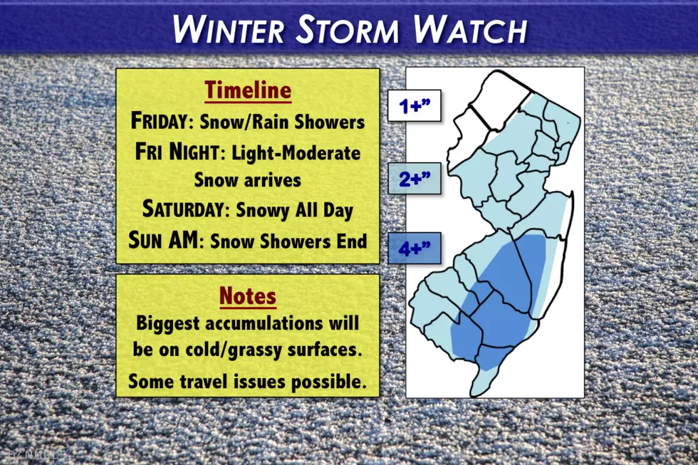
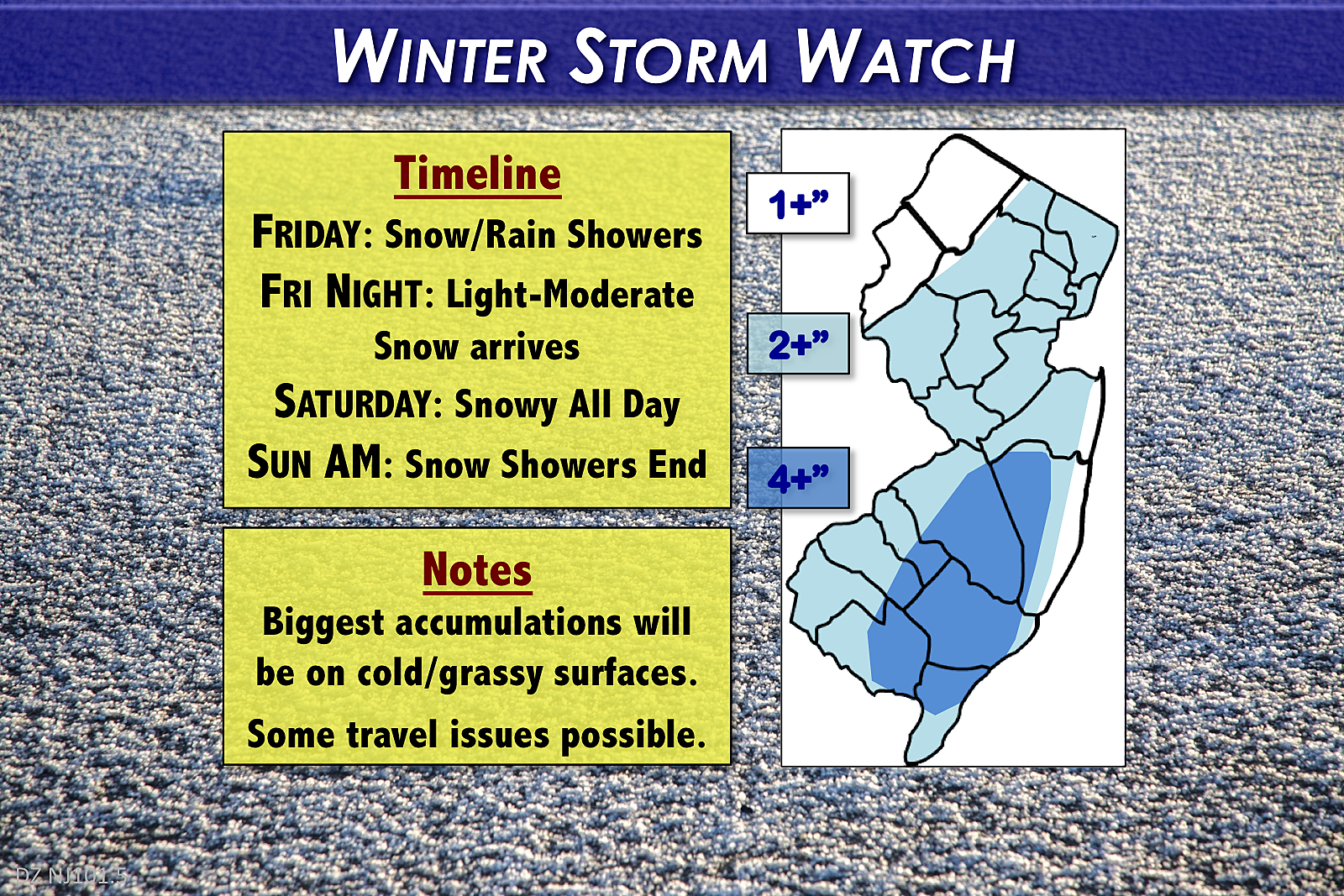
Timeline
Friday Daytime... Showers — either rain or snow — will be possible, from the front bands of the coastal storm system. These will be focused along southern and coastal New Jersey.
Friday Night... Light to moderate snow pushes in. Accumulation begins on cold surfaces (grass, cars, etc.) Untreated roadways eventually become slushy or icy.
Saturday... A snowy day. Expect steady snowfall through the morning and afternoon hours.
Saturday Night... Accumulation substantially done, as the storm tapers off to snow showers.
Sunday Morning... Snow showers end completely, with clearing skies by midday. Still cold, with a brisk wind too.
Snow Map Note
At the top of this article, you'll find the first snowfall forecast map of the season. One subtle change for my snow maps for this season compared to last season — I'm experimenting with using single numbers (1"+, 2"+, 4"+) rather than ranges (1-2", 2-4", 4-6"). Psychologically, I have come to believe it is far too easy for my audience to focus on just the top number of a given snowfall range, rather than thinking about the entire range of possibilities (with an additional margin of error on top of that).
The reality is that meteorology is an inexact science of probabilities and possibilities. And my job is to communicate the forecast as clearly and accurately as possible.
So I'm providing my best guess snowfall estimate for a given area, qualified with the requisite phrase "give or take". "Less is more" as they say, and I hope that by providing less information and less of a ranged "fudge factor," the forecast as a whole will be clearer. It will also make it much easier to verify my snowfall forecasts after the storm.
Again, just an experiment. Let's see how both you and I like the adjustment as the winter season progresses.
Totals
On the air, I am promoting 3 inches of accumulation, give or take, for most of New Jersey. We can refine that estimate a bit more.
So far this week, I've remained conservative and cautious about over-hyping such an early-season, marginal snow event. However, as I already mentioned, there is mounting evidence pointing toward a closer storm track and therefore higher snow totals. While it still won't qualify as a "major" winter storm — you can skip the "bread and milk" — there could certainly be some travel impacts through the duration.
It's important to note that, despite our freezing cold air, it's going to take a little while for snow and ice to accumulate on asphalt and concrete. Therefore, the biggest snowfall totals will be found on colder surfaces like grass, roofs, cars, etc.
Southern, Central, and Northeastern NJ... Again, it appears most of the state will see about 3 to 4 inches on the grass by the end of the day Saturday.
Interior South Jersey... Since precipitation will begin in South Jersey sometime late Friday, it's reasonable to expect the highest snowfall here. IF conditions are perfect — IF it's cold enough, IF snow falls in the moderate to heavy range, and IF we don't get dry-slotted — up to 6 inches of snow may accumulate here. (For the record, the latest NAM forecast model is pushing out an impressive 9 inches, but I don't buy it.)
Northwestern NJ... Oddly enough, the traditional coldest part of the state will almost certainly experience the least amount of snow from this storm. (Such a scenario is typical of coastal storms like this one.) As the steadiest snow bands miss to the southeast, I do think an inch or two is still possible for Sussex, Warren, and western Morris counties.
The Jersey Shore... One of the greatest challenges of this snow forecast. This area will be closer to the center of the storm, so precipitation intensity should be pretty steady throughout Friday night and Saturday . However, I'm worried about temperatures both at the surface and aloft being too warm (at times) to sustain all-snow. Any period of mixing would significantly decrease how much snow accumulates on the ground. I've reflected this prospect in the overall snow forecast, putting the Jersey Shore closer to 2 inches of accumulation.
Watch and Advisory

The National Weather Service has issued a Winter Storm Watch for the southern half of New Jersey, for counties along and south of Interstate 195. This includes Atlantic, Burlington, Camden, Cape May, Cumberland, Gloucester, Ocean, and Salem counties. In effect from 1 a.m. Saturday to 1 a.m. Sunday, a Watch means winter weather conditions may impair travel in the 24 to 48 hour time frame. It may be upgraded to a Warning later.
A Winter Weather Advisory has been posted for the central and northeastern portions of the state. The Advisory is in effect for Hunterdon, Mercer, Middlesex, Monmouth, and Morris counties from 1 a.m. Saturday to 1 a.m. Sunday. For Bergen, Essex, Hudson, Passaic, and Union counties, the Advisory is effective from 6 a.m. Saturday to 1 a.m. Sunday. An Advisory is less severe and less urgent than a Watch/Warning, and is generally issued when 3+ inches of snow is possible. Roads may be slippery, and travel may become difficult.
Action Steps
As I said already, you can skip the "bread and milk" on this storm. However, since it's the first snow of the season, I'll definitely be digging out the coat, hat, scarf, gloves, snow shovels, and snow blower before the storm. You'll probably want to do the same.
Consider your plans carefully for Friday night and Saturday. If you're not comfortable driving in the snow, and/or you don't have a vehicle capable of driving in icy conditions, you may want to adjust your schedule accordingly.
Forecast Confidence
No prediction is complete without a measure of the forecaster's confidence. I was hesitant to join the crowd in ramping up snowfall totals late Thursday, and wanted to see if Friday morning's models agreed with the new track and totals. Well, they did. So my forecast confidence is moderate — I feel good about being at the low-end of the regional snowfall forecasts, and ultimately I think I've given my audience enough time and notice to adequately prepare for the storm.
Having said that, there are still plenty of question marks throughout on this forecast. Will the storm wiggle further west, or back to the east? Will there be a dry slot, limiting snow totals? Will temperatures be too warm to sustain all-snow, especially along the coast? Did I go high enough with my snow totals in interior South Jersey?
There's no such thing as a "perfect" snow forecast. But my job, goal, and life's mission is to get as close as possible with every storm that comes New Jersey's way.
Next weather blog update scheduled for sometime Friday afternoon or evening.
Dan Zarrow is Chief Meteorologist for Townsquare Media New Jersey. Follow him on Facebook or Twitter for the latest forecast and realtime weather updates.
More From New Jersey 101.5 FM


