

Rain-to-snow and arctic blast for NJ this week: 9 things to know
UPDATE
This post represents our forecast as of the afternoon of Sunday, November 10th. Please visit my weather blog roll for the latest updates...
Bottom Line
For about a week now, we've been watching a storm system that looked interesting — as you know, this time of year, that term usually refers to the potential for wintry weather. Forecast models have converged on Tuesday morning as "prime time" for this cold front's arrival. And it looks like falling temperatures will indeed force a transition from rain to wintry mix and snow. While this is not a major winter storm for New Jersey, I think it's fair to suggest that Tuesday could get a little bit messy, with light snow/slush accumulations possible.
Forecast Confidence
Keep in mind, as of this writing, we're still about 36 to 48 hours away from the arrival of inclement weather. I'd call my forecast confidence right now "moderate" — while dramatic shifts in the timing and impacts are becoming less likely, there is still some built-in "wiggle room" in case the forecast shifts.
The Beginning
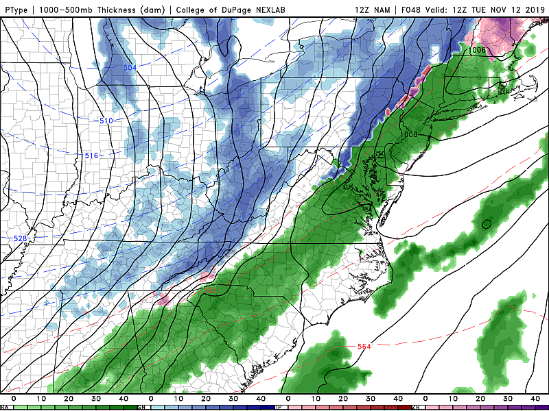
Precipitation will begin in NW NJ between Midnight and daybreak Tuesday morning, spreading throughout the entire state by around 7 a.m. With temperatures in the 40s (North) and 50s (Central, South), we're looking at all rain at onset.
The Middle
Shortly after the rain arrives, temperatures will crash as an arctic air mass pushes in. The big lingering question in this forecast is how quickly and how low temperatures will tumble before precipitation comes to an end. Last Thursday, those two elements did not phase well, leading to only limited snowflakes and no snow accumulation in New Jersey. This time around, things look a bit colder and therefore more impactful.
So we're facing a quick changeover from all rain to wintry mix to snow:
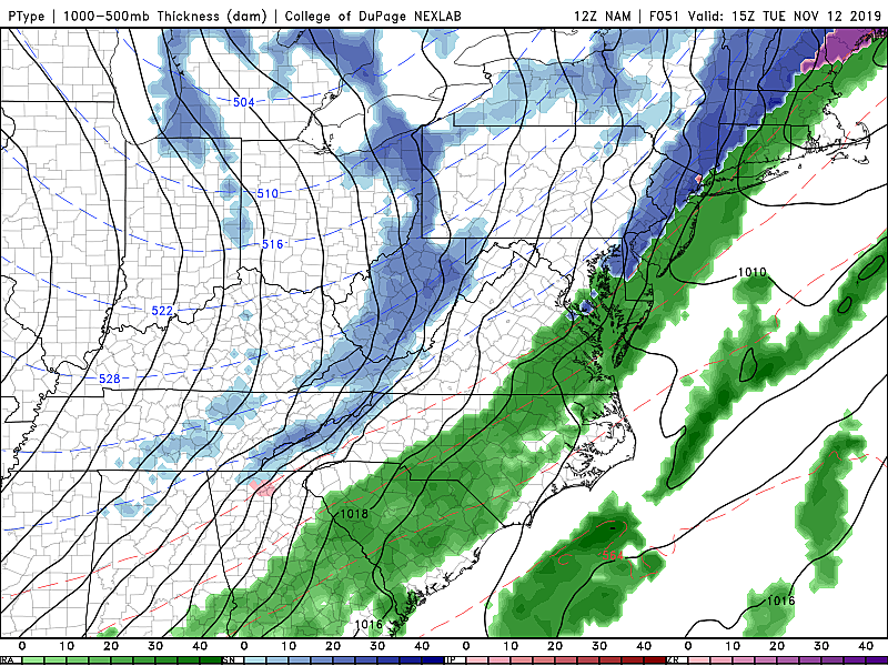
—For northwestern New Jersey, the transition from wet to wintry will begin around 8 a.m. to 10 a.m.
—The NJ Turnpike corridor will likely flip to mix or snow by lunchtime.
—Closer to the coast, temperatures may remain above-freezing for the duration, so any change to wintry precipitation will be brief (or may not happen at all).
The End
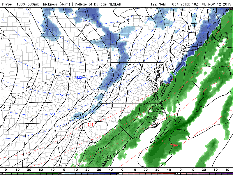
Any period of snowfall will not last long, as this storm system will begin winding down in NW NJ around late morning Tuesday. Precipitation will end along the south coast in the early afternoon. As drier air arrives, skies will become crystal clear by Tuesday evening.
Totals: How Much?
Again, we are not talking about a major winter storm here, which I loosely define as 6+ inches of snow causing widespread travel and infrastructure disruptions. It's probably not even advisory-level snowfall, which kicks in when the snow forecast hits 2 or 3 inches — enough to shovel and possibly plow.
This is nuisance snow, at worst. There are some significant limiting factors to snow forecasts this early in the season — the ground will be warm (and wet), the sun angle is relatively high, etc. And while we'll have an abundance of cold air (eventually), the storm system lacks any real "oomph" or moisture stream to fuel heavy snow.
Having said that, I do believe an inch or two of snow accumulation is possible for areas along and west of the NJ Turnpike. Barely enough to cover the grass. Probably not even enough to stick to asphalt, concrete, etc.
East of the Turnpike, especially in NJ's coastal counties (Monmouth, Ocean, Atlantic, Cape May), expect zero snow accumulation to a coating.
Remember, I only produce a snow forecast map when widespread 2+ inches of snow is expected in New Jersey. So no map needed for this one at this time.
Impacts: So What?
Tuesday morning's commute looks just wet for New Jersey. (Although again, we could start seeing more wintry weather in North Jersey by the end of the morning rush.) The most widespread mix/snow occurs during the work/school day. And the storm system exits well before the evening rush. All good news for travel conditions.
Once the transition from rain to snow takes place, road conditions may deteriorate rapidly and visibility will be reduced. As long as roads are treated before and during the storm, they should remain in good shape. Even during the subsequent flash freeze Tuesday night. As always, common sense is king.
I don't see many (if any) school districts altering their schedule on Tuesday. A delayed opening would make no sense, as it puts arrival time in the window of wintry weather. An early dismissal would be pointless too, as the wintry weather and/or cleanup would be ongoing. And an all-out snow-day/closure seems silly given the current forecast, for such a minimal amount of snow falling in the middle of the day.
After the Rain/Snow
Ha, and you thought this weekend was cold? Get the heavy coat, hat, and gloves ready.
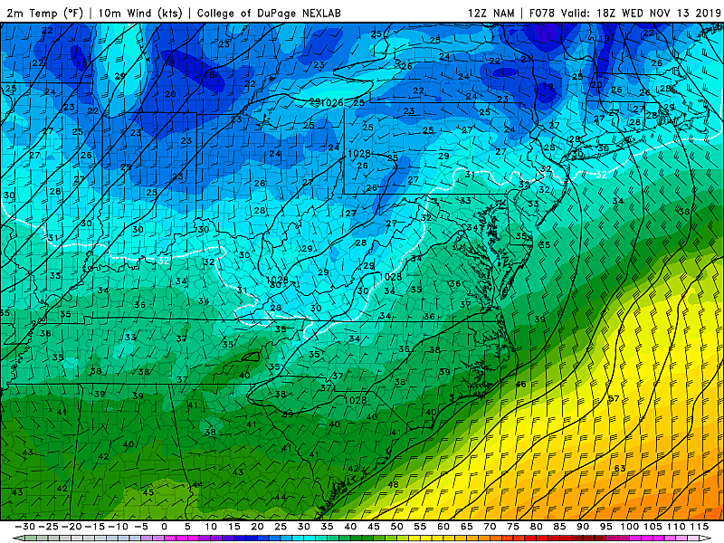
The air mass arriving with this cold front comes to us directly from the arctic. By Wednesday morning, we'll see widespread low temperatures in the teens and lower 20s. (Forecast low at Newark: 22, record low: 24.) As the wind blows, some wind chills may end up in the single digits. Brrr.
Wednesday afternoon, temperatures will struggle to even make it to the freezing point (32 degrees). Frigid.
Things should moderate somewhat for the rest of the week, with thermometers climbing into the (still below-normal) 40s on Thursday. The cold air is mostly a waste though, as our next storm system isn't forecast to come along until next Monday.
Stay Tuned
As always, our weather, traffic, news, digital, and programming teams are standing by to deliver critical information about any winter weather threat — no matter how major or minor.
My next weather blog will be published around 6 a.m. Monday morning.
Dan Zarrow is Chief Meteorologist for Townsquare Media New Jersey. Follow him on Facebook or Twitter for the latest forecast and realtime weather updates.
More From New Jersey 101.5 FM


