

This was NJ’s coldest winter in 11 years, and you won’t believe where it ranks since 1895
What a winter, huh?
The entire state of New Jersey spent a lot of quality time manning snow shovels and bundling up in our tightest winter gear over the past three months. Winter 2025-26 was a relentless reminder that New Jersey does experience all four seasons, and that does indeed include bitter cold and heavy snow.
From first flakes in early December to the snow/ice storm in January to the massive blizzard in late February, Mother Nature seemed determined to make up for years of mild, disappointing winter seasons.
My friend, colleague, and mentor, Dr. Dave Robinson, New Jersey State Climatologist at Rutgers University, coined a great phrase to describe this winter season overall: "Wash, rinse, repeat." In other words, we saw a nearly constant cycle of Arctic air moving in, dropping significant snow, and then we would barely catch our breath before the next system took aim at the Garden State.
It was a season of extremes that kept road crews busy and furnaces active.

Spring is now in full swing. And mid-May marks the official end of "snow season" in New Jersey — accumulating snow has never occurred this late in the season. So it is finally time to review the snowy, cold winter that was. (Keep in mind, in the world of weather statistics, climatological winter is calculated using the three average coldest months of the year: December, January, and February.)
Let's walk through some of the highlights and lowlights of Winter 2025-26, some of which are rather surprising.
Coldest winter season in 11 years
The average temperature for Winter 2025-26 — across all corners of New Jersey, across all hours of all days, between Dec. 1 and Feb. 28 — was calculated to be 29.7 degrees.
That makes it our coldest winter in 11 years, since the 2014-15 season. (In other words, since my very first winter season working at New Jersey 101.5!)
January was the coldest month, averaging 27.8 degrees. February's average temperature was 29.6 degrees. And December just barely averaged above freezing, at 32.3 degrees.
This three-month stretch of frigid weather was driven by a persistent dip in the jet stream that allowed persistent arctic/polar air to invade the Northeast United States. It wasn't just the cold; it was the duration of the deep freeze that made this year stand out from the much briefer arctic blasts of the last decade.
But only the 36th coldest winter in the last 132 years
This statistic is very surprising to me. Despite how frigid this winter felt and despite how much we were shivering, this winter only ranked as New Jersey's 36th coldest on record. And those detailed records go all the way back to 1895.
Surprisingly, that is not even in the top 25% of the class.
While we had plenty of mornings in the teens and single digits, we lacked the record-breaking, long-term deep freezes that used to define Jersey winters. This winter was a "top-tier" cold season for the 21st century — but many of the coldest years on record occurred before 1940.
Cold air is dry air
As the coldest air of the season settled into New Jersey in early February, the constant onslaught of snow shut off.
But cold air holds less moisture than warmer air. Every single month of winter saw below-normal liquid-equivalent precipitation across New Jersey. February, for example, saw only 2.01” of liquid — nearly an inch below average, and marked the 19th month out of the last 22 with a precipitation deficit.
So instead of overflowing reservoirs, we had spiraling drought concerns and a continuing Drought Warning as Winter turned to Spring. Not good news.
Snow lovers were in heaven this winter
There is no denying that this was an active, snowy winter across New Jersey. We experienced a total of 11 storms that produced at least two inches of accumulation somewhere in the state.
Oddly enough, most of those storms occurred on weekends and holidays this winter season. Even so, many school districts ran out of available snow days for the first time in many years, forcing students and teachers to sacrifice extra spring break or summer vacation days to compensate for the extra closures.
The season was headlined by two massive events, arguably New Jersey's biggest, most impactful, and most widespread winter storms since the Blizzard of January 2016.
The first snow-to-sleet event on Jan. 25 dumped up to a foot and a half of snow over North Jersey, along with a thick layer of ice. This was an uncharacteristic storm for New Jersey, because temperatures were incredibly cold for the duration — close to zero degrees in spots — making snow removal and storm cleanup exceptionally difficult, even on major roads.

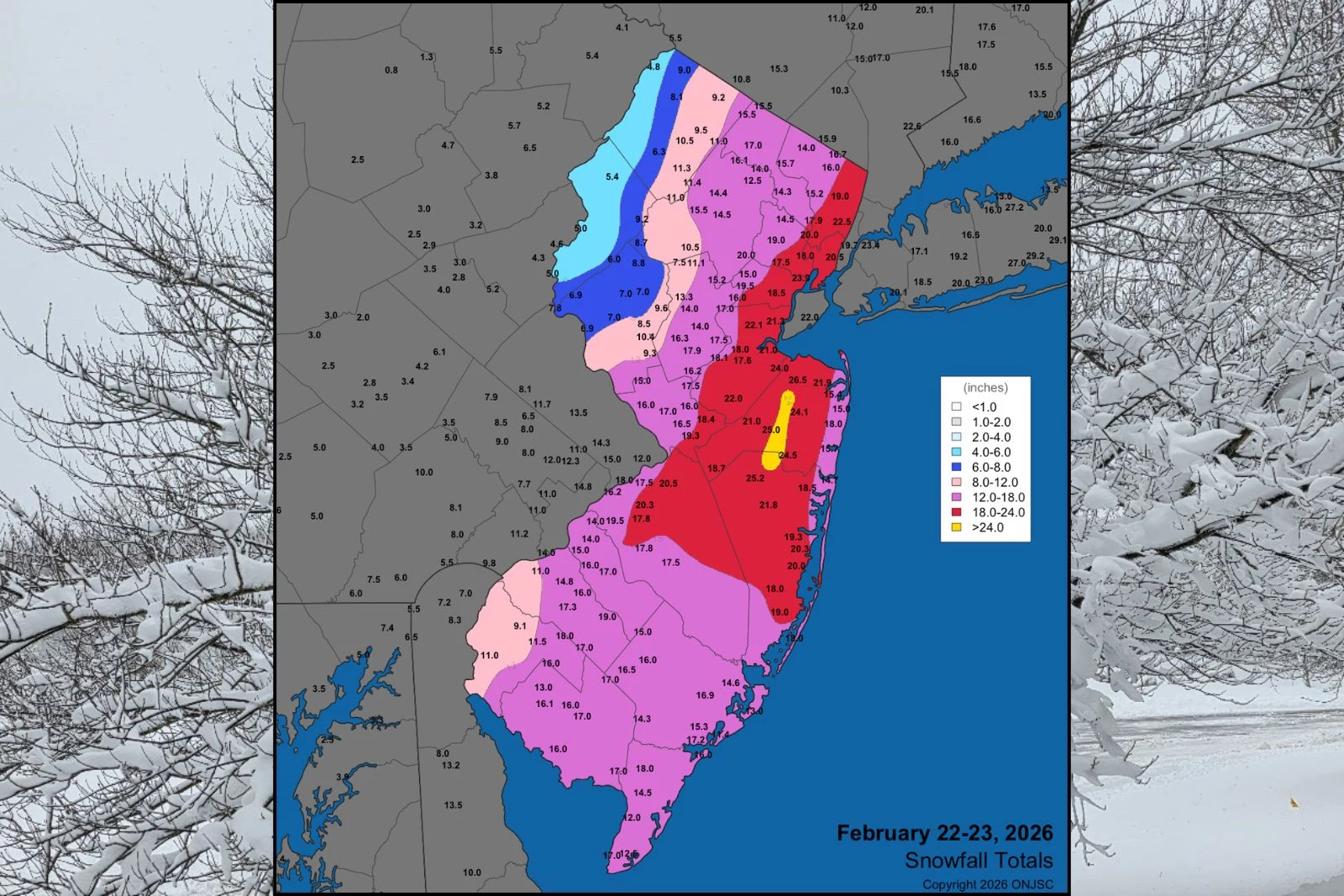
The second big storm, between Feb. 22 and 23, was deemed The Blizzard of 2026. Over two feet of snow accumulation was recorded in parts of Monmouth and Ocean counties. Blizzard conditions — meaning the combination of heavy snow and strong winds, leading to near-zero visibility — were officially confirmed for several coastal New Jersey counties.
Overall, many parts of North and Central Jersey finished the season with over three feet of total snowfall.
Winter 2025-26 was not necessarily an "extreme" winter. It was a return to typical New Jersey winter weather. It was a year that checked every box for plow drivers, skiers, and those who love crisp cold weather and stunning white landscapes.
As for me? I'm ready for Summer.
Final flakes: When does snow season end in NJ?
Gallery Credit: Dan Zarrow
Dan Zarrow is Chief Meteorologist for Townsquare Media New Jersey. Check out Dan's weather blog or follow him on Facebook for your latest weather forecast updates.
Glossary of NJ winter weather words and phrases
Gallery Credit: Dan Zarrow
More From New Jersey 101.5 FM


