
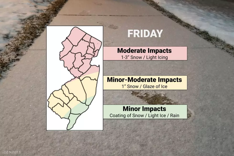
Not done yet: Additional inch or two of snow, glaze of ice Friday
UPDATE... This article is outdated...
For the latest winter storm forecast information, please refer to my newest weather blog post.
The Bottom Line
Our winter storm is still in the neighborhood and will send a few waves of wintry mix through New Jersey throughout the day Friday. It won't be as severe and sloppy as Thursday, but light accumulations, reduced visibility, and slushy roads are possible.
Timing
I don't want to dig too deeply into the exact timeline of Friday's wintry weather, because we'll have splotchy patches of snow and wintry mix and rain around throughout the day. The end time of this mess — meaning the final snowflakes, sleet pellets, and raindrops anywhere in the state — will be around 8 p.m.
Most of what falls from the sky Friday will be light. Having said that, models are hinting at approximately two pushes of heavier, more impactful stuff — one early morning (ramping up, as of this writing) and around midday.
Accumulations
The farther north you are, the better your chance of seeing additional light accumulations. North of the I-78 corridor, we could see upwards of 2 or 3 inches of additional snowfall. Between I-195 and I-78, an inch or two of fresh snow is possible. And south of I-195, I wouldn't rule out a healthy coating on the ground — if it's cold enough.
Meanwhile, the farther south you are, the higher the risk of additional icing on Friday. Some models paint over a tenth of an inch of ice accumulation, due to sleet and freezing rain. Even a little bit of freezing drizzle or freezing fog can make things shiny and slick. (As I discovered on my windshield early Friday morning!)
Keep in mind, these snowfall numbers are in addition to what's already on the ground. However, these numbers are included in the total snowfall maps I've posted previously. (That confusion is why I generally don't like posting new snow maps in the middle of a winter storm event.
Advisory
The threat of minor snowfall and minor-moderate icing means the Winter Weather Advisory continues for almost the entire state Friday, as follows:
—Until 10 a.m.... Cape May and coastal Ocean counties.
—Until 4 p.m.... inland Atlantic, Burlington, Camden, Cumberland, Gloucester, Hunterdon, Mercer, Middlesex, Monmouth, Morris, inland Ocean, Salem, Somerset, Sussex, and Warren counties.
—Until 7 p.m.... Bergen, Essex, Hudson, Passaic, and Union counties.
The Extended Forecast
Friday is my 33rd consecutive day of work, following a very active period of winter weather. Saturday will not be day #34, I'm happy to say.
We'll see clearing skies Friday night, especially after Midnight. It's going to be cold, thanks in part to our fresh snow cover, with low temperatures in the upper teens to mid 20s.
Skies on Saturday will be mostly sunny. But it will be breezy and cold, with highs barely above the freezing mark. That northwesterly wind could blow in a few snow showers, especially in North Jersey. I wouldn't rule out a dusting or coating if one of those shows turn a bit squall-ish.
More sunshine for Sunday. And more 30s too.
Our next storm system is set to arrive on Monday. It's a fast-moving clipper system, that will arrive from the west in the late morning or early afternoon hours (depending on which model you agree with). This one is trending a little snowier to the northwest of the NJ Turnpike corridor. (I think that's a matter of timing more than anything else.) Models are going as high as 2 or 3 inches in NW NJ now — possibly creeping into "advisory" territory. We'll keep you posted as this one continues to evolve.
Meanwhile, southeast of the Turnpike on Monday? Looks like just plain rain.
If all goes well, we'll be treated to a warmup through the middle of next week. Possibly some 50s? That would be glorious.
There are no major winter storms on the horizon (although some close calls) through the end of February.
Be smart, stay safe, and keep warm on this second wintry day in a row. And have a great weekend!
Dan Zarrow is Chief Meteorologist for Townsquare Media New Jersey. Follow him on Facebook or Twitter for the latest forecast and realtime weather updates.
LOOK: 15 Discontinued McDonald's Menu Items
More From New Jersey 101.5 FM


