
Nor’easter to be even stronger, hit NJ even sooner: Monster storm coming
The vast majority of New Jersey is now expected see double-digit snow totals and blizzard conditions, starting Friday night.
All week long, I've dedicated myself to staying true to my forecasting philosophy and meteorological mantra: HONESTY FIRST. I've worked so hard to battle all the hype and hysteria and excitement, while always keeping in mind our big blizzard bust last January. Being first to issue a snow forecast, promoting the highest or lowest snow totals out of anyone, and even precision and accuracy? Hyperbole and hype will always lose to forecast and personal integrity.
So ... to be honest ... my previous snowfall forecasts for this storm ... were too low. This storm is turning into quite a monster, and I have to adjust my forecast in the 11th hour to reflect that.
I even hinted at my concerns in this morning's forecast update, suggesting that "you might want to take the "over" bet on my forecast." I hope you did ...
Here's the latest:
Stronger ...
You know, was not expecting to do an afternoon forecast update, but here we are!
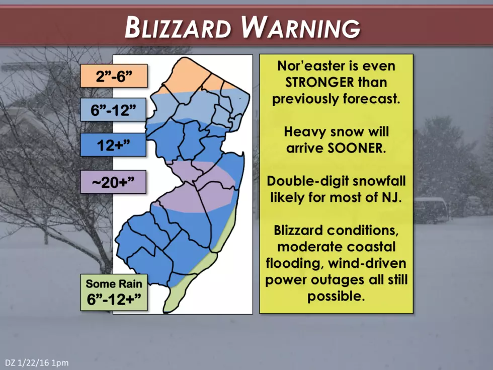
Snowfall on the 12Z afternoon models (all but the Euro and previously strong NAM) took a jump northward, and there is now consensus for double-digit snow totals across the vast majority of New Jersey. The new snowfall "sweet spot" is along the Route 195 corridor, where over 20 inches of snow will be possible. Incredible.
New Jerseyans along and south of Interstate 78 should expect over a foot of snow. Far North Jersey and the southern coast should be spared the full brunt of the snowstorm... However, healthy accumulations are still expected for all but northern Sussex County.
Faster ...
Additionally, the worst part of the storm is expected to move in sooner than previously forecast. While the first snowflakes are expected in southwestern New Jersey by around sunset, the snow will then intensify rapidly and begin to accumulate quickly.
Here's a brief outline of the new timing of the PEAK of the storm. This reflects when I expect the snow to accumulate the fastest and travel will be nearly impossible:
• South Jersey: 7 p.m. Friday to 11 a.m. Saturday
• Central Jersey: 11 p.m. Friday to 5 p.m. Saturday
• North Jersey: 3 a.m. Saturday to 10 p.m. Saturday
I suggest you plan to get home (or wherever you are hunkering down) before the worst of the storm arrives.
Stays the Same ...
All potential storm impacts besides snow remain the same, even as the storm and forecast have evolved. This includes:
• Winds: Sustained at 25 to 35 mph, with gusts to 60+ mph (especially along the coast)
• Visibility: Near-zero (blizzard conditions)
• Ocean Waves: 14 to 20 feet (severe beach erosion likely)
• Storm Surge: 3 to 4 feet (moderate coastal flooding expected)
In Summary ...
I'm literally sick to my stomach stressing over this late-in-the-game development and forecast change. Blah. But this is the way I see the forecast evolving, given the latest data and information. Go ahead, call me a terrible meteorologist for changing the forecast only three hours before the first snowflakes fall - all I can do, and all I can promise you every day, is to honestly forecast the weather as I see it.
The final accumulated snowfall map for this storm is going to be incredible. The tight gradient I've been talked about for days? Snow totals could range between practically nothing to two feet of snow accumulation from the top to the middle of New Jersey. That's just ridiculous.
Just as we started tracking this storm days ago, I joked that our ultimate forecast might just call for 0 to 25 inches of snow. Joke? How about reality.
We'll continue to keep you updated. Please stay safe out there.
Dan Zarrow is the Chief Meteorologist for Townsquare Media New Jersey. Follow him on Facebook or Twitter for the latest forecast and realtime weather updates.
More From New Jersey 101.5 FM


