

NJ weather: Rain then snow this weekend, dangerous cold next week
UPDATE... This article is outdated...
For the latest storm forecast information, please refer to my newest weather blog post.
UPDATE as of 2:30 p.m. Friday...
After reviewing this afternoon's latest model runs, I decided to tweak the snowfall map I produced Friday morning. In the end, I think this makes more sense — both in terms of forecast model consensus and understanding by my audience.
I still consider this a conservative call — some guidance and some forecasters go as high as 8, 10, and even 12 inches of snow somewhere in New Jersey from this storm. But I am not 100% confident these "big snow" totals will occur. And I am even less sure exactly where such a heaviest snow band would set up.
Timeline still looks good, with prime wintry impacts from Sunday afternoon through evening.
This forecast will evolve and become more refined over the weekend. Look for my next full forecast update Saturday morning.
ORIGINAL POST (with edits) from 8:40 a.m. Friday...
The Bottom Line
As you can tell by the headline, we have a lot of weather coming up in the 5 Day Forecast. Including two different flavors of potentially hazardous winter weather, accumulating snow and dangerous cold.
In a nutshell: Friday looks pleasant, Saturday turns wet, Sunday brings snow, and then Monday through next week will be ridiculously cold.
Whether you have places to go, things to do, or are looking forward to the Eagles-Rams game, it seems everyone's attention is on Sunday's snow chance. And rightfully so — the forecast has trended decidedly snowier and more impactful over the last 24 hours.

While "big snow" totals up to 10 inches are on the table for Sunday, I am deliberately taking a more conservative approach. I have some reservations about presenting a forecast that high this early. (First flakes are still over 48 hours away.) So I have presented my "opening bid" of 0 to 6+ inches — and let's talk further about how that forecast may change over the weekend.

Friday
The one pleasant day between this past week and next week.
We start the day with a fresh coating of snow on the ground from Thursday night. Top snow total in NJ was 0.8". The sun should make quick work of that snowy blanket Friday morning. Until then, you might be scraping off the windshield and watching for slippery spots.
Expect sunny skies, light winds, dry weather, and seasonable temperatures throughout Friday. Highs will reach about 40 degrees — right on the normal high temperature for mid-January.

Friday night stays quiet, with clouds increasing after Midnight. Lows fall to around 30.
Saturday
Technically, Saturday will be the warmest day of the week. It will also be the wettest, although that is not saying much.
High temperatures will bump into the mid 40s, despite abundant cloud cover. I would not even rule out 50 degrees in South Jersey.
Between the midday and afternoon hours, we will likely see a batch of rain dampen NJ's day. It is not an all-day rain, and I do not see any "pouring" rain potential. Just light showers, with less than a quarter-inch of total rainfall.

There is a very limited opportunity for wintry mix among the hills of northwestern New Jersey, in and around Sussex County. Little to no accumulation is expected, although there could be some slippery spots.
We will dry out by Saturday night. Temperatures may once again dip to 30 degrees. But that should not be a hard enough freeze to cause widespread icing of wet surfaces from the earlier rain..
Sunday
Here's when things get interesting. And by that, I mean wintry.
A cold front will arrive Sunday morning, sending temperatures tumbling once again. High temperatures will probably be limited to the lower to (maybe) mid 30s around midday. The early part of Sunday will feature a mix of sun and clouds and an occasional breeze.

Then snow moves in. And it does look to accumulate across the vast majority of New Jersey. The window for wintry weather is about Noon to Midnight — so centered on the Sunday afternoon and evening hours. (The brunt of the storm, with steadiest snow, looks to be around the early evening hours.) Road conditions will deteriorate quickly, as snow sticks to untreated surfaces quickly and obscures visibility.
My forecast looks a little different than what others have put out there. (Heck, it is unlike anything I have ever published before.)
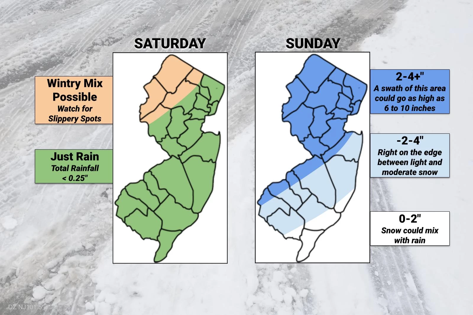
As it stands, I believe we will average 3 inches across most of the state. Overperformance is possible, especially along and west of the NJ Turnpike corridor. Totals along the southern coast may be affected by mixing with rain or sleet. A pretty classic NJ snow storm set up, that is highly track dependent.
I am thinking of this forecast like playing a hand of poker. 2 to 4 inches is my initial wager, then I raised to 3 to 6 inches. If my cards still look good after the "flop" — meaning if models are still conducive to a snowy scenario — I might "raise" my accumulation forecast again. Hence the "plus" on the dark blue area. (Some forecast models go as high as 11 inches.) If things trend in the other direction, I might have to "check" or "fold" and go lower. (There are several forecast models that show minor accumulations of less than three inches across the board.)
I have a rule in winter weather forecasting — I never hype the idea of "major snow" (6+ inches) unless I am reasonably sure it is going to happen. And I am not sure here. I'm not certain whether the storm system will be close enough to produce that much snow, especially given the ongoing cold air intrusion. Furthermore, if the snowiest scenario does play out, I can not tell you exactly who in the state would be most likely to see 8, 10, or even 12 inches.
So the bottom line is this: Expect accumulating snow late Sunday. Accumulations likely in the "light to moderate" range. It does not look like a blockbuster historic blizzard, but there will be widespread travel impacts. Plan accordingly — keeping in mind this storm is occurring over the weekend, and roads should improve by Monday morning. (Which is Martin Luther King Jr. Day, by the way.)
Bottom line #2: Please stay up-to-date on the forecast throughout the weekend, because it will change as we get new data, new information and insight, and a better idea of how this is going to play out. I pledge to give at least one full forecast update on Saturday, and then one more on Sunday.
Monday & Beyond
Weather in a word next week: Cold.
In two words: Very cold.
By Monday morning, with a fresh snowpack, low temperatures are expected to drop to around 10 degrees. With a bitter breeze, pushing the wind chill (the "feels like" or "apparent" temperature) down toward zero.
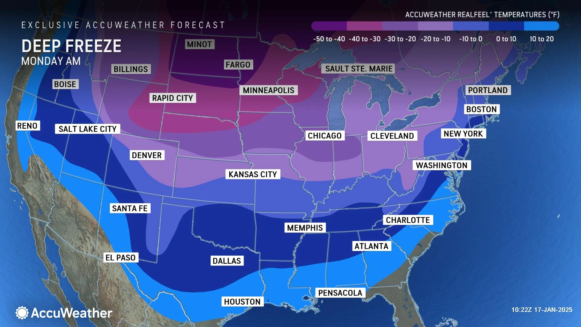
Monday afternoon's highs will only reach the lower 20s or so. Partly sunny, dry, and breezy.
Tuesday morning, we should see widespread single digits across New Jersey. Wind chills may dip to -5 to -10 — that is "dangerous" cold territory. Highs on Tuesday will only reach the mid-upper teens.
More of the same for Wednesday, singles in the morning (some below zero in North Jersey) and teens in the afternoon.
The last time we had a 2-day stretch of high temperatures only in the teens was January 2018. Seven years ago! (At the Newark, New Brunswick, and Atlantic City weather stations.)
Temperatures will moderate a little bit on Thursday. But my latest forecast only shows mid 20s for highs. Still in the deep freezer.
As for the impacts of this extreme cold, I have to quote the National Weather Service's AM forecast discussion, which said it succinctly and accurately: "There is quite high confidence that this multi-day period of dangerously cold temperatures will occur, resulting in impacts to people, animals, and infrastructure. Dangerously cold conditions for people and animals are possible resulting in an increased risk of hypothermia and frost bite. For infrastructure, impacts could include freezing water pipes and high demand for heating energy."
The next opportunity for a storm would be late next week, in the Friday to Saturday time frame. With a frigid ground and rising temperatures, I will be worried about the icing potential if a storm does develop.
Let it snow: 12 things to know about winter forecasting in NJ
Gallery Credit: Dan Zarrow
Dan Zarrow is Chief Meteorologist for Townsquare Media New Jersey. Follow him on Facebook for the latest forecast and realtime weather updates.
Glossary of NJ winter weather words and phrases
Gallery Credit: Dan Zarrow
More From New Jersey 101.5 FM


