Here’s how Hurricane Erin will impact the NJ coast this week
There are two prominent weather stories we have to talk about here. The first is a big cooldown, as New Jersey faces its coolest stretch since mid-June. The fall-like temperatures will come with cloudy skies and occasional sprinkles too. Of course, all eyes are on Hurricane Erin, menacingly churning up the Atlantic Ocean. The storm will stay several hundred miles east of New Jersey, meaning direct weather impacts will be minimal to non-existent. However, coastal impacts will be significant and potentially dangerous, ranging from big waves to beach erosion to rip currents to tidal flooding. Residents and visitors of the Jersey Shore need to pay very close attention to this forecast.

Short-range NJ weather: Cooler, cloudy, showery
Change is in the air! And pretty soon, a taste of fall will be in the air as cooler, drier air works into New Jersey.
That cold front is working through the state from north to south Monday morning. As it does, a refreshing breeze will kick up — gusting over 20 mph in spots. Humidity will drop quite a bit by midday. And temperatures will dip into the 60s.
I think thermometers will recover to about 70 to 75 degrees by Monday afternoon. (Although that is dependent upon that stiff breeze dying down and some peeks of sun along the way — there is a chance that some spots get stuck in the 60s, especially north and coast.)
It will be a "blah" weather day overall, with lots of clouds and spotty sprinkles around. The best chance of raindrops will be to the south and along the coast. No more than a few hundredths of an inch of additional rainfall are expected.
Monday night will stay mostly cloudy, with comfortably cool low temperatures mainly in the lower 60s. Some 50s are possible in the coolest corners of the state.
Tuesday and Wednesday will bring more of the same. Both days will be mainly dry, although some hit-or-miss showers or sprinkles can not be ruled out. Temperatures will remain in the 70s, making this our coolest stretch of weather since mid-June.
80s return later this week. Our next chance of widespread rain will not come along until the second half of next weekend.
How Hurricane Erin will NOT impact New Jersey: Rain, wind, severe weather
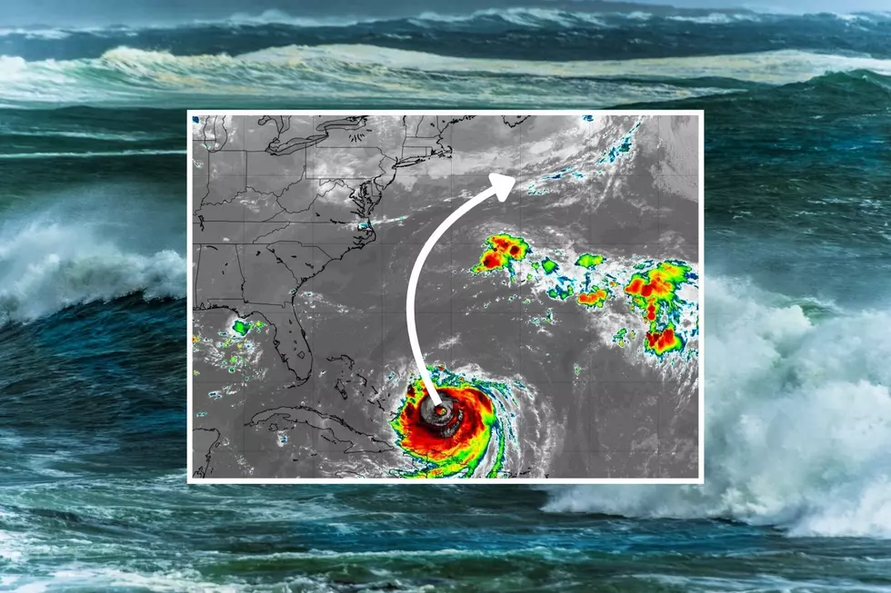
Hurricane Erin's forecast track has been locked in for a few days now. It has started to turn to the north, scraping past the eastern edge of the Bahamas on Monday. And then it will zip directly in between the U.S. mainland and Bermuda. For a storm of this magnitude to not make a single landfall is not only fortunate, it is exceptionally rare.
The latest forecast puts the center of Erin anywhere between 325 and 525 miles off the Jersey Shore at its closest pass on Thursday. (Average = 425, plus the standard margin of error for a tropical storm forecast three days out.) At that point, the extent of tropical storm force winds (39+ mph sustained) on our side of the storm (northwest quadrant) is forecast to radiate out about 280 miles.
So in the worst-case scenario, marginally strong wind and rain bands will be close to New Jersey. But still not quite reaching here.
Keep in mind, because of the direction of motion and the direction of spin, the right-front quadrant of a hurricane (the northeast) causes the most dramatic impacts — the strongest winds, the highest storm surge, and the greatest risk of tornadoes. That is the other side of the storm from New Jersey.
Therefore, I maintain that Erin's weather impacts will be minimal for New Jersey:
—Rainfall... Zero.
—Wind gusts... Up to 30 mph along the immediate coast. Up to 20 mph inland. I would call that breezy.
—Sky cover... A bank of clouds may hang over the Jersey Shore throughout the day Thursday. Farther inland, sunshine should win out.
—Severe weather / Tornadoes... Highly unlikely.
Can Erin's track shift, putting us more in harm's way? I suppose it could change just enough to bring us something more impactful. But there has not been a single forecast model run that has shown truly dangerous or tropical weather here in New Jersey. Honestly, if I had any concerns or reservations at all, I would tell you.
How Hurricane Erin WILL impact New Jersey: Angry ocean
Erin's powerful wind is pushing out some strong long period swell, churning up the entire Atlantic basin. That means we do have to ring some alarm bells for coastal issues along the Jersey Shore, starting now and lasting all week.
The waves emanating from the core of the storm are going to be massive. According to the model image I posted above, significant wave heights could reach over 40 feet over the open ocean.
But remember: New Jersey will be hundreds of miles from that center. So we won't see 40-foot waves smashing into the Jersey Shore. But 6+ foot breaking waves can still be significant and highly impactful.
Here is a rundown of the coastal impacts for the Jersey Shore, by the numbers:
—Wave Heights... 2 to 4 feet Monday, 3 to 6 feet Tuesday, 6 to 10 feet Wednesday and Thursday.
—Rip Current Risk... High, for the foreseeable future, at least through the start of the weekend. (At least the ocean will look very rough and formidable.)
—Beach Erosion... Moderate to Severe. (It is difficult to quantify erosion, as impacts are highly localized and may vary from town to town and from beach to beach.)
—Coastal Flooding... 2 to possibly 3 feet of storm surge will push up against the Jersey Shore later this week, which is enough to push tidal waterways into the minor flooding category. That translates to "the usual spots" that tend to see water pool during any major coastal storm. (Keep in mind, tidal guidance is only accurate and useful 72 hours out, so we are only just starting to get data on this impact — stay tuned for more as the storm's closest pass approaches.)
The one piece of fortunate news here is the less-than-stellar weather, which will hopefully keep people away from the beaches and out of the dangerous ocean. I am very concerned that after Erin passes by, skies turn sunnier, and temperatures warm late-week that people become complacent or ignorant. The ocean will still be very rough and dangerous for Friday and likely Saturday too.
Long-range NJ weather: More tropical waves?
Signs are pointing toward additional tropical waves forming behind Erin, as we approach the climatological peak of the Atlantic hurricane season (early to mid September). Some have suggested these waves have an even greater chance of a U.S. landfall.
I have the opposite opinion, however. As a major hurricane, Erin is a massive energy hog — pumping out a massive amount of "Accumulated Cyclone Energy (ACE)". The ocean corridor through the tropical Atlantic may very well be "zapped" of available energy for additional storms to form and explosively develop, with the potential for generally cooler water temperatures.
Of course, it will be important to keep an eye on any potential developments throughout the Atlantic basin. It only takes one storm to make for a memorable hurricane season. The next name on the list for the Atlantic in 2025 is Fernand followed by Gabrielle.
The complete list of names for the 2025 Atlantic Hurricane Season
Gallery Credit: Dan Zarrow
Dan Zarrow is Chief Meteorologist for Townsquare Media New Jersey. Follow him on Facebook for the latest forecast and realtime weather updates.
15 common sense flood preparation tips
Gallery Credit: Dan Zarrow
More From New Jersey 101.5 FM