
From waves to wind: 10 things to know about Hurricane Erin’s impacts on NJ
What's the weather for now?
Many New Jerseyans — including myself — are loving the "hoodie weather" that has enveloped the state this week. A nice break from the heat and humidity.
A stalled frontal boundary just to the south will keep scattered clouds over New Jersey on Tuesday. It will also push spotty sprinkles through South Jersey only. Overall, it will be an OK weather day, especially if you catch some breaks of sun along the way.
Temperatures will rise from the 60s in the morning to the lower-mid 70s in the afternoon. That is 10 degrees below normal for this time of year, more typical of mid-September than mid-August.
Wednesday will be cloudier and more humid, with highs jumping into the upper 70s. A chance of showers and maybe even a thunderstorm will kick in starting around midday.
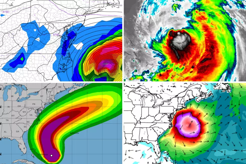
Just how close will Hurricane Erin get to New Jersey?
There have been some subtle changes to Hurricane Erin's forecast. Namely, the wind field is now modeled to be a bit wider than previously thought. And the storm track has "wiggled" slightly to the west, closer to the coast.
To be crystal clear, the center of Hurricane Erin — where the truly catastrophic hurricane-force impacts lie — will stay hundreds of miles off-shore. I am just talking about a slight upgrade in our wind, shower, and coastal flooding concerns here in New Jersey.

As of 5 a.m. Tuesday morning, Erin is a category 3 major hurricane, with maximum sustained winds of 115 mph. It is centered about 1,000 miles south of New Jersey, making its turn to beeline in between the U.S. Mainland and Bermuda.
At its closest pass on Thursday afternoon, Erin's center will be about 350 miles southeast of the Jersey Shore. At that point, hurricane force winds (74+ mph sustained) will extend about 90 miles from the center. Tropical storm force winds (39+ mph sustained) will radiate about 290 miles to the northwest. (And again, we will be about 350 miles away at that point, give or take.)

So the worst-case track scenario brings those tropical storm force winds very close to the Jersey Shore. I think the forecast trend warrants an upgrade in impacts and wording, as you'll see in the rest of my forecast below.
Should I go swimming in the ocean?
Absolutely not. Please and thank you.
We already have a High Risk of dangerous rip currents posted along the Jersey Shore Tuesday.
And several beaches have opted to close completely, banning swimming until the dangerously rough ocean calms down.

How big will the waves get?
Wave height estimates for Tuesday are 3 to 6 feet for Jersey Shore beaches. This is actually due to a combination of a brisk easterly on-shore wind and the long period swell stemming from Hurricane Erin.
Ocean waves will climb to about 4 to 8 feet on Wednesday. 10-foot breakers are possible on Thursday, as Erin makes its closest fly-by.

Hundreds of miles out to sea, near the center of the storm, ocean waves will be 40+ feet. Not a good week for a deep sea fishing excursion.
How windy will it get?
Again, I have had to increase our wind expectations given the last forecast model trends.

The coast may experience gusts as high as 40 mph. Inland areas could see gusts to 30 mph.
(For the record, there is no such thing as a "tropical storm force gust". Tropical storms and hurricanes are measured by sustained winds, not gusts. Period.)
40 mph is not strong enough to cause major damage. Think blown garbage cans, driving difficulties, and downed branches. That is advisory criteria. And enough to cause sporadic (not widespread) power outages. Worth raising an eyebrow, at least.
What's the latest on the coastal flooding outlook?
Now that the storm is 48 hours away, we have a better view of the coastal flooding potential. And I do not like what I see.

Thursday evening's high tide cycle now falls firmly in the Moderate Flooding category. That is getting pretty serious, as 2 to 3 feet of storm surge may necessitate some road closures around high tide and could even cause property damage. This level of flooding goes beyond your "typical, everyday water rise" — it would be on par with most strong coastal storms like nor'easters.
For now, it is only the Thursday evening high tide that raises alarm bells. But that is only because we do not have good data on Friday morning's tide levels yet. I doubt we are looking at round after round of water inundation here. Once the storm departs, tide levels should then return to normal.
What about rain?
This answer is a little bit complicated, since Erin will interact with a stationary front already draped over the mid-Atlantic.
I am now including the chance of a stray shower in Thursday's forecast, primarily along the coast. Nothing heavy or tropical — just a few hundredths of an inch of rainfall, if that.
At the very least, the westward jog in the storm track makes me think skies over New Jersey will be mostly cloudy to overcast statewide on Thursday.
Could this forecast get worse?
No weather forecast is complete without an assessment of the forecaster's confidence — how certain they are the prediction will come true, and/or how it might evolve over time.
In this case, I am highly confident that Erin's true tropical storm force and hurricane force impacts will stay out to sea. It would take a dramatic shift for the storm track to change that much. Especially given how consistent model guidance has been and continues to be.

Having said that, a storm wiggle of another 50 miles closer to the coast would not be extraordinary. And that might necessitate another step up in New Jersey's wind, coastal flooding, and shower forecast.
At the same time, there is about an equal chance that the storm wobbles 50 miles in the other direction, eliminating the shower chance and power outage threat completely.
Bottom line: It is important to keep monitoring the forecast, especially if you live along a tidal waterway. We will continue to keep you updated before, during, and after the storm.
When will ocean conditions improve?
I think my greatest concern overall is that when the sun comes out on Friday and temperatures warm back into the 80s, the ocean will still be very rough.
The same will be true for Saturday. It is the penultimate weekend of the summer season. New Jersey families want to hit the beach. The weather forecast looks fantastic. But there will still be a moderate to high risk of rip currents and rough surf.
I don't think the ocean will really calm down until Sunday at the Jersey Shore. Don't be ignorant, don't be complacent — the surf will remain downright dangerous until then.

How does the extended forecast look?
As I mentioned, both Friday and Saturday look like outrageously nice weather days, with sunshine, lower 80s, and refreshingly low humidity.
Our next chance of widespread rain looks to come into play Sunday into Monday. The forecast for most of next week is looking good, with temperatures at or just below seasonal normals for late August.
In the tropics, there are indications that additional tropical waves will develop into organized cyclones within the next 5 to 7 days. I think that depends on whether there's any "gas left in the tank" after Erin's pass through the area disturbed much of the warmest ocean water.

There is also a ton of hype floating around that the next storm will aim for Florida, the East Coast, etc. — There is no way forecast models have any handle on what is coming down the 'pike until Erin clears the basin.
There's still plenty of time left in summer and the Atlantic hurricane season. As always, calm vigilance is the way to go.
The complete list of names for the 2025 Atlantic Hurricane Season
Gallery Credit: Dan Zarrow
Dan Zarrow is Chief Meteorologist for Townsquare Media New Jersey. Follow him on Facebook for the latest forecast and realtime weather updates.
15 common sense flood preparation tips
Gallery Credit: Dan Zarrow
More From New Jersey 101.5 FM


