NJ weather: Frigid Friday, weekend warmup, rain returns
The Bottom Line
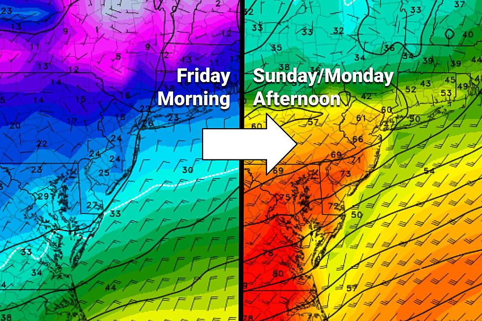
The wild temperature swings continue. We'll go from 10 degrees below normal on Friday, to 20+ degrees above normal (and near record highs) on Sunday. But with rising temperatures this weekend will also come clouds and some rain showers.
And, of course, we have to look ahead to our inevitable cooldown too. That's set to arrive early next week, alongside a period of steady rain.
Friday
If this were the middle of January, in the dead of winter, this would be a totally typical day. But early March is late winter —this chill is unseasonable and not very welcome at all.
It's actually New Jersey's coldest morning in almost two weeks. We're starting off around 20 degrees, give or take. (Many wind chills are in the teens.) And highs will only reach about 35 to 40 degrees Friday afternoon. At least that's above freezing, although not by much.
Skies will be sunny. Air and weather will be dry. And winds will generally be light.
Friday night won't be quite as cold as the previous night, with lows averaging upper 20s. So another freeze is likely, away from the immediate coast. Clouds will start to roll in after about Midnight.
Saturday
Temperatures moderate to more seasonable and more comfortable levels. Thermometers should come close to 50 degrees Friday afternoon. Skies will be mostly cloudy. And we could see some spotty sprinkles around. Maybe some drizzle and fog developing Saturday night, as our warm front lifts through New Jersey.
Sunday
Runaway, record warmth! But it's not a perfect day.
A round of scattered rain showers is expected from Sunday morning through about midday. The wettest spot here looks to be the northern half of the state. Total rainfall should be pretty light, below a quarter-inch.
The entire day looks breezy, with winds out of the southwest up to 20+ mph. And it will definitely be warm, with highs in the upper 60s to around 70.
If all goes well, we'll see peeks of sunshine Sunday afternoon. If we get substantial sunshine, I wouldn't rule out widespread 70s, putting record highs in jeopardy. Records are 65° at Newark, 69° at Trenton, and 68° at Atlantic City airports. My latest forecast is for 68° at EWR, 69° at TTN, and 70° at ACY — a tie or break at all three.
Monday
Still warm. But our inevitable transition to cooler days will begin.
Most high temperatures will again end up close to 70 degrees. North Jersey will be a notable exception, closer to 60 degrees.
Eventually, we'll get soaked, as rain moves in some time Monday. The timing of those raindrops is hazy — GFS favors a Monday morning start, the Euro holds off the wet weather until Monday evening. Rainfall will be steady, if not heavy, at times through Monday night. Total rainfall could top an inch for much of NJ.
With precipitation falling and a cooldown underway, we do have to keep our eyes open to the potential for wintry weather. (Snow season is definitely not over yet.) I think there is a chance for some wintry mix at the tail-end of that storm system early Tuesday morning. But only in the colder, higher elevations of NW NJ.
Tuesday & Beyond
Tuesday will be 20 to 30 degrees cooler than Monday. But really that just knocks back thermometers to near-normal levels. We should settle in the upper 40s or so Tuesday afternoon, with late-day clearing.
Wednesday looks like a nice early March day, with lower 50s and sunshine.
Our next storm system arriving late next week could be one to watch. As things stand now, it looks like a rain to snow/mix event from Thursday midday through early Friday morning. But the wintry solution will only happen if the timing is just right and temperatures are cold enough. So it's still way too early to deduce whether we'll see another inch of rain, or a few inches of snow. I wouldn't put away the shovels and salt just yet.
Have a great weekend!
Dan Zarrow is Chief Meteorologist for Townsquare Media New Jersey. Follow him on Facebook or Twitter for the latest forecast and realtime weather updates.
2022 Seaside Heights Polar Bear Plunge photos
Gallery Credit: Andrew Miller/For Townsquare Media NJ
NJ's Route 22 circa 1984 — Do you recognize these businesses?
Gallery Credit: Joe Votruba
More From New Jersey 101.5 FM


