
NJ weather: Big rain and wind, then coldest Christmas in decades
UPDATE... This article is outdated...
For the latest winter storm forecast information, please refer to my newest weather blog post.
The Bottom Line
Mother Nature is about to make this busy holiday week very challenging. A broad, multi-impact storm is about to sweep across the northern half of the country, dumping major snowfall from the Northern Plains to the Midwest to New England.
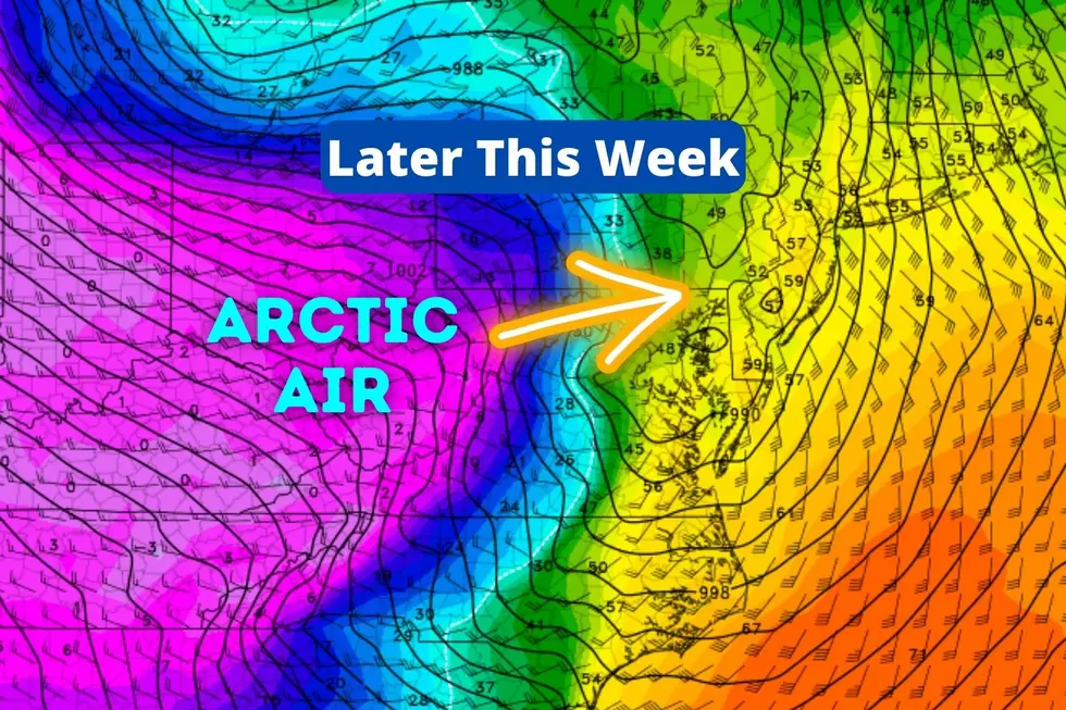
Here in New Jersey, we face troubles of our own. Although Tuesday and Wednesday will remain quiet, Thursday turns wet. Thursday night will be very wet and windy. And then our first arctic blast of the season arrives Friday.
The end result: New Jersey's coldest Christmas Eve and Day since 1989, over 30 years ago.

The Calm Before the Storm
Tuesday is starting off very similarly to Monday. Temperatures are mainly in the 20s to start the day. Once again, we'll see plentiful sunshine, dry conditions, and chilly temperatures. Highs will only reach about 40 degrees Tuesday afternoon. That is about 5 degrees below normal for the last full day of fall. At least winds will be lighter than Monday.
Wednesday stays quiet. With periods of sun and clouds overhead, high temps will push into the lower 40s.
Ramping Up: Thursday
Here's where things get interesting. You may recall the storm timeline was the biggest question mark left to resolve. Well, things have fallen into line pretty well now — our weather will turn nasty for a period of 24 to 36 hours.
Thursday will start cloudy, with warming temperatures. Most of New Jersey will push into the 50s by the end of the day. That's why this is a wet forecast for New Jersey, and not a wintry one.
Spotty rain showers may bubble up into South Jersey as early as Thursday morning. Depending on the exactly timing and temperatures, there is a small risk for a few minutes of freezing drizzle at onset. Very, very limited though.
Rain will really fill in across the state Thursday afternoon through early evening.
The Brunt: Thursday Night
We really get soaked — and windswept — Thursday night. Very heavy rain will combine with strong winds to make for some incredibly stormy, nasty conditions through early Friday morning. Let's call the brunt of the storm about 8 p.m. Thursday through 4 a.m. Friday.
By the numbers, we'll probably end up with 1 to 3 inches of rainfall, with the biggest totals to the north. WInd gusts may touch 40 to 50 mph. Again, nothing wintry with temps in the 50s. But I would not be surprised at all if some thunder and lightning develop.
Tumultuous: Friday
Conditions should ease and rain/wind should lull for a short time Friday morning. Hopefully coinciding with the AM commute.
And then, as a strong cold front pushes in from the west, one more round of precipitation is likely from Friday morning through midday. Once again, it looks wet. But there will be some cold air in the neighborhood, so a quick hit of snow is possible on the backside. I doubt there will be any accumulations or slippery spots, since the ground will still be warm and wet (insulated).
Arctic air is forecast to crash into New Jersey sometime Friday afternoon, sending temperatures and dew points tumbling. Thermometers are going to drop from the 50s into the 20s — within just a few hours. The change will be very noticeable. Especially since it will be accompanied by a strong arctic wind. Once again, I could see wind gusts approaching 40+ mph.
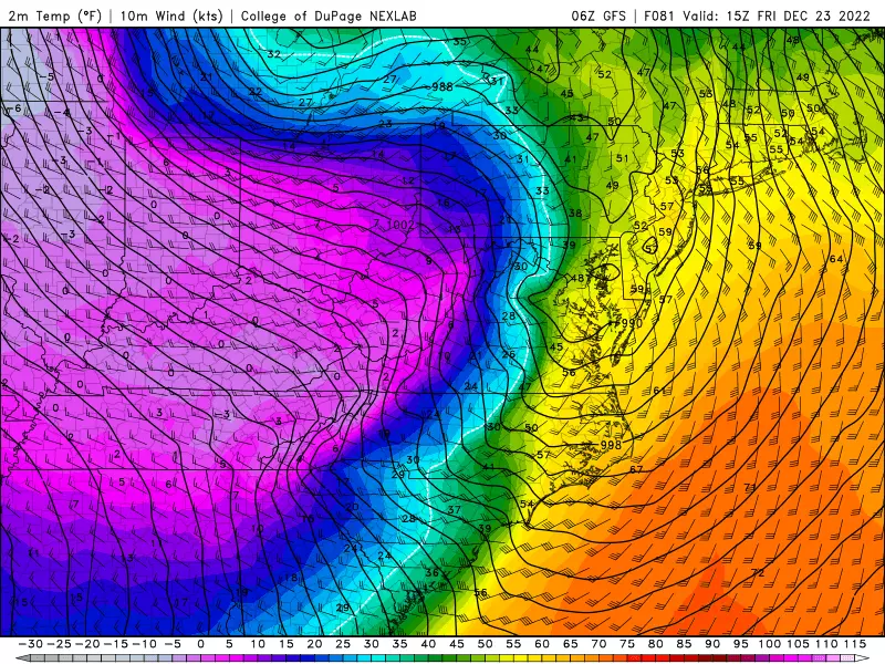
A flash freeze is a possibility, as temperatures crash below freezing so quickly that puddles and wet surfaces ice over.
Frigid: Saturday & Sunday
Saturday is Christmas Eve. Sunday is Christmas Day. And then are both going to be incredibly cold.
Morning lows in the teens. Afternoon highs only in the 20s — the entire state will be stuck below freezing all weekend.
That's not record-breaking, but highly unusual for late December. The last time we had a Christmas with highs only in the 20s? 1989.
Plus, the wind will continue to roar, especially on Saturday. That could push wind chills down to near zero. That is approaching the extreme cold "danger zone". So make sure you are dressing appropriately for this unseasonably frigid weather.
The Extended Forecast
Boxing Day Monday stays frigid. Then temperatures moderate through the last week of the year. Our next substantial storm system shows up in long-range models around New Year's Eve. But once again, I suspect a warmup will cause a rainy scene rather than a snowy one.
Dan Zarrow is Chief Meteorologist for Townsquare Media New Jersey. Follow him on Facebook or Twitter for the latest forecast and realtime weather updates.
Light Up New Jersey: Best holiday displays of 2022
Gallery Credit: Light Up NJ — Vote here
A list of NJ malls where you can get photos with Santa for the 2024 holiday season
Gallery Credit: Mike Brant
More From New Jersey 101.5 FM


