

How much rain soaked NJ during Monday’s severe flooding event?
The atmosphere was warm and humid. Flood watches were posted. Alarm bells were sounded. And the atmosphere dumped.
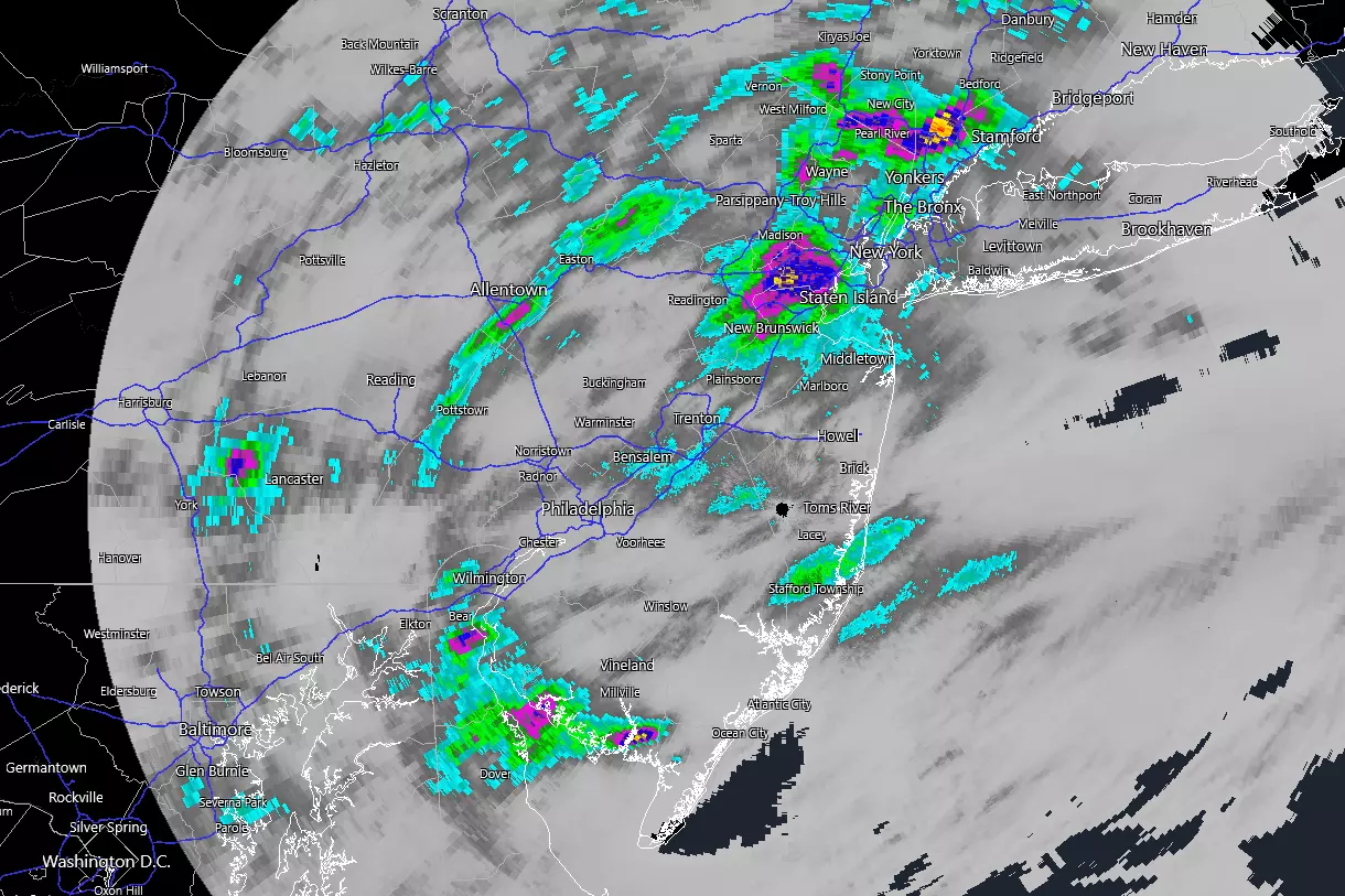
Buckets of rain fell over parts of New Jersey on Monday, sparking New Jersey's most significant flooding event in several years. (Arguably since the remnants of Ida on September 1, 2021.) The lightning and wind were pretty wicked too.
Storm impacts ranged from swamped cars to flooded businesses to a house explosion. Sadly, two people died in Plainfield when their car was swept into a brook. Governor Murphy declared a State of Emergency to make resources and money available for recovery and cleanup efforts around the state.

Rainfall Bullseye
The hardest hit corner of the state was around Union and Somerset counties, where rounds of heavy rain tallied a half-foot by late Monday night. Keep in mind, normal rainfall for the entire month of July — New Jersey's average wettest month of the year — is a little more than four inches. So parts of the state picked up half a summer's worth of rain in just one evening.
The rainfall reports are in. (From about 500 weather stations across New Jersey, in fact.) And the overall "winner" was Clark Township in Union County, with 6.67" of rain from Monday through Tuesday morning. That total was recorded by a volunteer observed through the Community Collaborative Rain, Hail, & Snow Network — fondly known as CoCoRaHS.
The Wettest Counties
Two NJ counties recorded those incredible rainfall totals over 6 inches: Somerset and Union.
An additional three counties in NJ saw at least one weather station with over 4 inches of rain: Middlesex, Morris, and Ocean.
The following nine NJ counties picked up at least 2 inches of solid rain in at least one spot: Bergen, Burlington, Cumberland, Essex, Mercer, Monmouth, Passaic, Sussex, and Warren.
The remaining seven counties in the state saw top rainfall totals between 1 and 2 inches: Atlantic, Camden, Cape May, Gloucester, Hudson, Hunterdon, and Salem.
Historic Rainfall
According to extreme precipitation statistics in NOAA Atlas 14, six inches of rain within six hours exceeds the 100-year return period. In other words, there is only a one percent probability of such an event occurring in any given year.
So yes, this degree of rain and flooding event is unusual. Yes, it is record-breaking. Yes, it is historic.
County-by-County Top Rainfall Reports
I am only recapping the top five or top ten rainfall totals for each of New Jersey's 21 counties, to give a snapshot of just how much rain soaked each corner of the state.
Atlantic County
1.11 inches — Hammonton
0.62 inches — Folsom
0.48 inches — Mullica
0.45 inches — Egg Harbor City
0.39 inches — Estell Manor
Bergen County
3.97 inches — Palisades Park
3.76 inches — Franklin Lakes
2.84 inches — River Vale
2.79 inches — Leonia
2.55 inches — Tenafly
2.30 inches — Wood-Ridge
2.29 inches — Tenafly
2.26 inches — Teterboro Airport
2.26 inches — New Milford
2.22 inches — Hasbrouck Heights
2.04 inches — Mahwah
Burlington County
2.05 inches — Pemberton
2.05 inches — Mansfield
1.86 inches — Burlington
1.73 inches — Bordentown
1.68 inches — Willingboro
1.50 inches — Columbus
1.41 inches — McGuire AFB
1.27 inches — Westampton
1.07 inches — Cinnaminson
0.99 inches — Moorestown
Camden County
1.11 inches — Winslow
0.60 inches — Pennsauken
0.41 inches — Pennsauken
0.31 inches — Cherry Hill
0.30 inches — Barrington
Cape May County
1.66 inches — Woodbine
1.27 inches — Eldora
0.58 inches — Dennis
0.36 inches — Middle
0.34 inches — Ocean City
Cumberland County
2.29 inches — Fortescue
1.61 inches — Greenwich
1.58 inches — Vineland
1.08 inches — Millville Municipal Airport
1.03 inches — Bridgeton
Essex County
3.06 inches — Millburn
2.92 inches — Maplewood
2.19 inches — West Orange
2.05 inches — Newark
1.94 inches — West Caldwell
1.75 inches — Orange
1.59 inches — Caldwell Essex County Airport
1.49 inches — Fairfield
1.39 inches — Livingston
1.23 inches — Montclair
Gloucester County
1.49 inches — Glassboro
0.67 inches — Monroe
0.64 inches — Piney Hollow
0.61 inches — Franklin
0.45 inches — Pitman
Hudson County
1.50 inches — Jersey City
1.28 inches — Hoboken
1.22 inches — Harrison
1.12 inches — Kearny
1.03 inches — Hoboken
Hunterdon County
1.16 inches — Teetertown
1.14 inches — Califon
0.78 inches — Lebanon
0.57 inches — Holland
0.52 inches — Frenchtown
Mercer County
2.39 inches — Hamilton
1.88 inches — Princeton
1.67 inches — Hopewell
1.27 inches — Allentown
1.12 inches — Pennington
Middlesex County
5.35 inches — Edison
5.27 inches — Middlesex
3.85 inches — Woodbridge
3.52 inches — North Brunswick
3.41 inches — New Brunswick
3.37 inches — Highland Park
2.91 inches — Metuchen
2.86 inches — Carteret
2.65 inches — East Brunswick
2.58 inches — Milltown
Monmouth County
2.63 inches — Matawan
2.25 inches — Keyport
1.94 inches — Manalapan
1.84 inches — Freehold
1.74 inches — Holmdel
1.71 inches — Middletown
1.36 inches — Red Bank
1.27 inches — Little Silver
1.19 inches — Monmouth Beach
1.03 inches — Colts Neck
Morris County
4.47 inches — Long Hill
4.17 inches — Butler
3.88 inches — Chatham
3.40 inches — Montville
3.33 inches — Pequannock
3.31 inches — Pompton Plains
3.12 inches — Pleasant Plains
2.90 inches — Madison
2.40 inches — Lincoln Park
2.22 inches — Whippany
Ocean County
4.07 inches — Stafford
2.49 inches — Seaside Park
2.41 inches — Lacey
1.71 inches — South Seaside Park
1.61 inches — Manchester
1.40 inches — Barnegat Light
1.33 inches — Jackson
1.16 inches — Berkeley
1.08 inches — Fort Dix
0.85 inches — Toms River
Passaic County
2.59 inches — Pompton Lakes
2.56 inches — Ringwood
2.51 inches — Wayne
2.14 inches — North Haledon
1.84 inches — West Milford
1.51 inches — North Haledon
1.36 inches — North Caldwell
1.21 inches — Hawthorne
1.01 inches — Little Falls
0.88 inches — Clifton
Salem County
1.11 inches — Lower Alloways Creek
1.07 inches — Woodstown
0.91 inches — Salem
0.40 inches — Mannington
Somerset County
6.51 inches — Watchung
6.48 inches — Green Brook
4.31 inches — Franklin
4.16 inches — Bridgewater
4.06 inches — Manville
3.76 inches — Middlesex
3.74 inches — Somerset
3.18 inches — Hillsborough
3.17 inches — Basking Ridge
2.67 inches — Bernards
Sussex County
2.15 inches — Montague
2.07 inches — Lafayette
1.96 inches — Vernon
1.20 inches — Hardyston
1.11 inches — Walpack
Union County
6.67 inches — Clark
6.40 inches — Westfield
5.79 inches — New Providence
5.35 inches — Mountainside
5.10 inches — Linden
4.81 inches — Westfield
4.56 inches — Cranford Twp
4.38 inches — Linden Airport
4.10 inches — Bayside
Warren County
3.21 inches — Liberty
3.15 inches — Oxford
2.82 inches — Mansfield
2.81 inches — Hackettstown
2.69 inches — Lopatcong
2.63 inches — White
2.49 inches — Pequest
2.17 inches — Franklin
2.17 inches — Phillipsburg
1.84 inches — Washington
15 common sense flood preparation tips
Gallery Credit: Dan Zarrow
Dan Zarrow is Chief Meteorologist for Townsquare Media New Jersey. Check out Dan's weather blog or follow him on Facebook for your latest weather forecast updates.
Incredible, heartbreaking images of Ida's damage in New Jersey
Gallery Credit: Dan Alexander
More From New Jersey 101.5 FM


