

New Jersey nor’easter snowfall, in a word: Intense
Most of the Garden State is bracing for a period of very heavy snowfall Wednesday, with 6 to 12+ inches in the latest forecast.
FORECAST UPDATE: Overnight, forecast models promoted a last-minute shift of the center of our nor'easter, in the eastward direction. As we've discussed, this puts the storm closer to the "sweet spot" where colder temperatures perfectly combine with heavier snowfall to create a formidable winter storm over New Jersey. Therefore, I've made a last-minute adjustment to the forecast, bumping snow totals higher along the Interstate 295 corridor in particular. I've also added a note to my snowfall forecast map, showing the area of the state most likely to see snow totals over a foot. Everything else (timing, wind, coastal impacts) looks good.
SO FAR: Rain and snow showers arrived right on time Tuesday evening. Some areas of the state already have a healthy coating on the ground, especially for grassy surfaces. This is just the appetizer course of this nor'easter, as heavier snow bands form later Wednesday.
INTENSE: Between about 10 a.m. and 5 p.m. Wednesday, you don't want to be on the road. Models suggest some truly intense mesoscale snow bands will just pour snow out of the sky. Snowfall rates may exceed 3 inches per hour. Very heavy snow will significantly impact travel during this time — driving will be very difficult, if not impossible. Hundreds of area flights have already been cancelled for Wednesday.
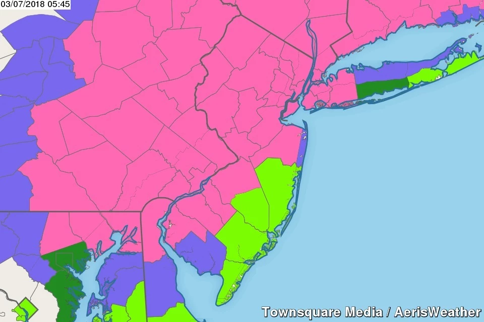
WINTER STORM WARNING: All or part of 17 of New Jersey's 21 counties fall under a Winter Storm Warning through early Thursday morning. Coastal Monmouth and Cumberland counties are presently under a Winter Weather Advisory. No snow alerts have been posted for Ocean, Atlantic, or Cape May counties.
WIND: Sustained winds will hover in the 15 to 25 mph range throughout the day, with wind direction shifting from northeast (nor'east) to northwest as the storm pushes through. Gusts to 30+ mph are expected for inland New Jersey, with gusts to 40+ mph along the Jersey Shore. Unfortunately, the combination of strong winds and heavy snow will likely cause additional power outages.
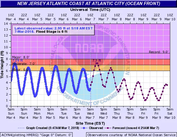
COASTAL FLOODING: Still a concern, especially as water levels remain elevated in back bays and tributaries from last week's nor'easter. A Coastal Flood Advisory has been issued for the entire Jersey Shore. Note: not a warning. For the next two high tide cycles — around Noon Wednesday and Midnight Thursday — widespread minor to localized moderate flooding of tidal waterways is likely. Vulnerable roads in coastal NJ may need to be closed at times. Remember to never attempt to drive, walk, or swim through flooded areas.
THE END: The intense snowfall will taper off Wednesday evening, with snow showers ending around Midnight. We'll enjoy breaks of sunshine by Thursday morning, as mild temperatures in the 40s kickstart the snowmelt.
DON'T BE STUPID: Yes, this storm is "just" a snowstorm. But major snow can still be dangerous if not fatal if you're reckless and/or stupid. 96 percent of winter storm fatalities occur as a result of motor vehicle accidents. Stay off the roads if at all possible, both to stay safe and allow road crews to clear the snow and ice as the storm rages on.
WE'RE HERE: Our weather, news, traffic, and talk teams have initiated full Winter Weather Alert coverage. We'll have regular updates all day, both on-air and online, so you can stay informed and stay safe.
Dan Zarrow is Chief Meteorologist for Townsquare Media New Jersey. Follow him on Facebook or Twitter for the latest forecast and realtime weather updates.
More From New Jersey 101.5 FM


