
Heavy snow, sleet, rain for NJ Sunday night: Timeline and totals
Timeline
—2 p.m. Sunday... Outer edge of storm system arrives in southwestern New Jersey, spreading north through the rest of the afternoon. With temperatures in the 40s, don't be surprised if it's just rain to start.
—5 p.m. Sunday... Precipitation now falling just about everywhere in New Jersey. This is the critical point of the storm — as temperatures drop due to nightfall and a cooling atmosphere, rain transitions to snow for most.
—6 p.m. to 9 p.m. Sunday... Road conditions will become very poor very quickly Sunday evening, as moderate to heavy snow falls and accumulates for all but New Jersey's southern coast.
—9 p.m. Sunday to 1 a.m. Monday... Transition from snow to sleet to rain underway within the I-295 and I-195 corridors. Bands of very heavy snow continue to impact the "sweet spot" farther north in NJ.
—1 a.m. to 4 a.m. Monday... Heaviest bands depart, but snow continues to fall and accumulate for North Jersey. A brief flip from rain/mix back to snow is possible for part of South Jersey.
—4 a.m. to 7 a.m. Monday... Snow/rain ends completely from west to east. Let the shoveling begin!
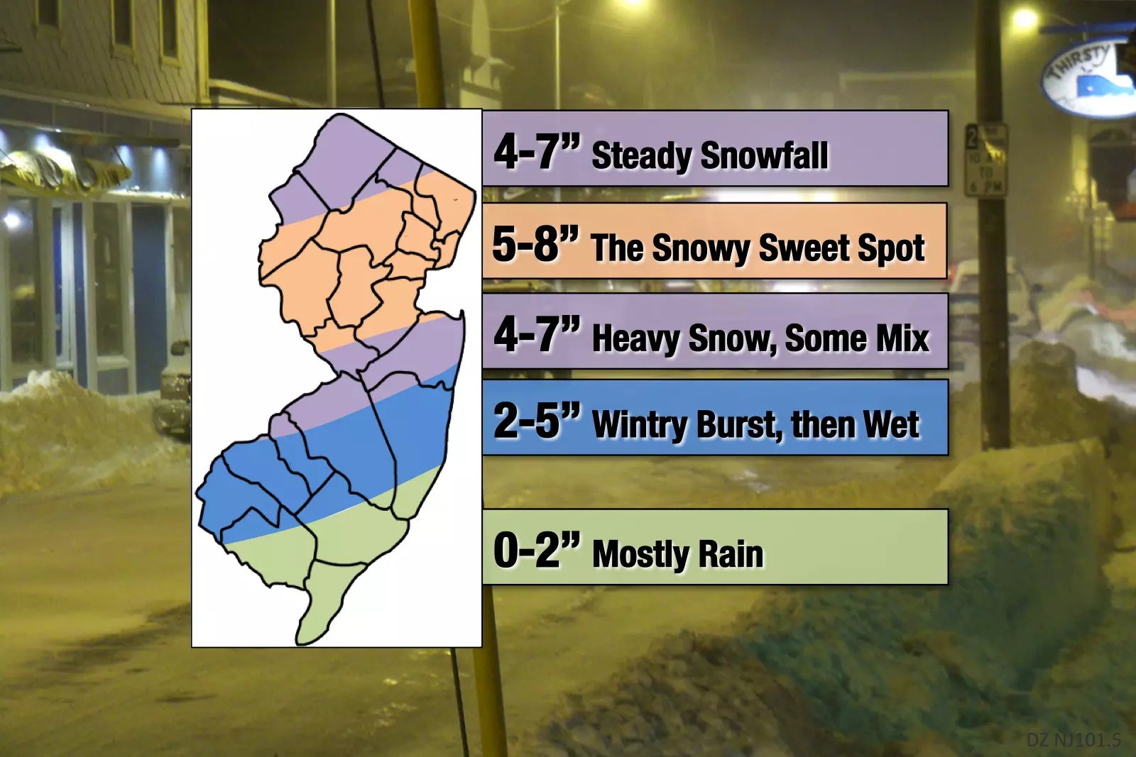
Totals
As we've been discussing for many days, this storm presents a significant forecasting challenge. Somewhere over New Jersey, there is going to be a sharp cutoff line between "that's hardly any snow" and "oh, that's a lot of snow". In this final forecast, I've tried my best to refine and pinpoint where that line is most likely to end up.
The bottom line is if you live north of a line stretching from about Camden to Jackson to Long Branch, you are most likely going to see travel-inhibiting snowfall from this system. South of that line, you will probably see some snow, but accumulations may be limited due to mixing and/or rainfall.
—Steady Snowfall (4 to 7 inches)... Far North Jersey may fall just north of the heaviest mesoscale snow bands, so I've placed slightly reduced totals here. This area stretches from the Delaware Water Gap, through most of Sussex and Warren counties, all the way to Mahwah in northern Bergen County.
—The Sweet Snowy Spot (5 to 8 inches)... Much of northern and central NJ is expected to remain snow for most of the storm (expect for onset). Here, we may see inch-an-hour snowfall during the peak of the storm, leading to quick accumulations. Isolated 10" totals are not out of the question here. This sizable area includes Flemington, Bridgewater, Morristown, Edison, the Brunswicks, the Amboys, the Plainfields, Elizabeth, Newark, and Jersey City. There is a chance the heaviest snow bands weaken before reaching the immediate NYC metro area, but I'm not betting on it.
—Heavy Snow, Some Mix (4 to 7 inches)... This stripe of Central Jersey that includes Long Branch, Freehold, Trenton, Bordentown, and Camden. But I think some mixing with sleet and even rain could limit snowfall totals slightly. It's still going to be a wintry night here.
—Wintry Burst, then Wet (2 to 5 inches)... From rain to snow to sleet and back to rain, this is our transition zone. This is also the area of the state with the greatest uncertainty — where I believe the line between "hardly any snow" and "a lot of snow" will end up. Travel conditions will become treacherous here Sunday evening, before we transition to "just wet" by Monday morning. This zone stretches from Salem, through the southern and eastern edges of the Philly metro area, to Toms River and Brick.
—Mostly Rain (0 to 2 inches)... Southern coast, this ain't your storm. In fact, it's still totally feasible that you see absolutely no snow from this storm. However, I am leaving the possibility alive for a quick inch or two of accumulation Sunday evening. This includes places like Vineland, Millville, Cape May, Atlantic City, and Stafford Township. General rule: the farther inland you are, the greater your snow potential.
Warning/Advisory
A Winter Storm Warning, calling for downright dangerous travel conditions, has been issued for the following times for the following NJ counties:
—1 p.m. Sunday to 7 a.m. Monday... Bergen, Essex, Hudson, Passaic, and Union.
—3 p.m. Sunday to 7 a.m. Monday... Burlington, Camden, Gloucester, Hunterdon, Mercer, Middlesex, Monmouth, Morris, inland Ocean, Salem, Somerset, Sussex, and Warren.
A Winter Weather Advisory, warning of slippery roads and reduced visibility, has been posted for:
—3 p.m. Sunday to 7 a.m. Monday... Atlantic, Cumberland, and coastal Ocean.
Nothing for Cape May County.
Confidence
I feel most certain about the location and magnitude of this storm's sweet spot — the purple and orange segments of the map above.
The timing forecast also seems to be locked in across the suite of model guidance.
I do still have concerns about snow underperformance south of Interstate 195, due to the predominance of rain and/or sleet. I remain dubious about the need for warnings (rather than advisories) along the I-295 and I-195 corridors.
But for a final call, we have to play it safe. Out of an abundance of caution, and all that jazz. (Rather than "2 to 5 inches" for southwestern New Jersey, I almost want to say it's looking like "2 or 5 inches" instead.)
For decision-makers in the blue and green areas, I highly recommend you wait until the last minute to delay or close schools, business, etc. (If possible, of course.)
Impacts
I can not express strongly enough how rapidly road conditions will deteriorate as the storm flips from rain to snow Sunday evening. With snowfall rates potentially in excess of an inch per hour, accumulations are likely to occur quickly (even on treated road surfaces). I highly recommend you get off the road by about 6-7 p.m. Sunday at the latest, if you can help it. And stay off the roads until after the snow stops (after 4 a.m.) so road crews can do their job to clear the state.
School delays and closings will be widespread on Monday, especially in the Warning area. Although heavy snow will stop falling by the Monday morning rush hour, snowy, slushy, and/or wet roads will still be a significant hazard for drivers.
Final Thoughts
This will likely become New Jersey's second biggest winter storm of the 2018-2019 season. (Falling behind the overperforming November 15th "Brinegate" storm that dumped a foot of snow over far northern NJ.) I've been saying for weeks (if not months) that early March would roar like a lion. And here you go, snow lovers — you can revel in your wintry glory for a night and a day
Behind the storm, expect bitterly cold temperatures to settle in. Thermometers could remain below freezing from Monday evening through Thursday or Friday afternoon. Overnight wind chills may occasionally visit the single digits. Our next storm chance won't come until the very end of the week.
Is this a "bread and milk" storm? Not really. The state is not going to be crippled for days on end. You're not going to be stranded in your house for more than half-a-day. However, if you're caught in your vehicle during the brunt of the storm, that may be a different matter. It's not really a "nasty" storm as the icing potential, wind gusts, and coastal flooding threat are low. We've lucked out that this is mostly a weekend storm, limiting the number of people on the roads.
Still, I hope you're taking it seriously and making good decisions to keep yourself, your family, and your property safe and warm.
I'm about to head into the radio station to ride out the storm, because I'm nervous about commuting in the middle of the stormy slop early Monday morning. Our news, digital, programming, traffic, and weather teams are all on "storm mode" ready to bring you the latest information during and after the storm.
Stay smart, be safe, and enjoy the snow!
Dan Zarrow is Chief Meteorologist for Townsquare Media New Jersey. Follow him on Facebook or Twitter for the latest forecast and realtime weather updates.
More From New Jersey 101.5 FM


