

Heavy rain and gusty wind hits NJ Sunday into Monday
Batten down the hatches and hold onto your hat - it's going to be a downright nasty day and a half of weather for the Garden State.
Five years ago, New Jersey was bracing for one of the worst weather days in recorded history — the landfall of Superstorm Sandy. This October 29th, we're expecting another busy weather day. While the impacts won't be nearly as severe as those from Sandy, the tropical rains, the strong winds, and scattered power outages may be an eerie reminder of that day.
For a complete outline detailing the meteorological setup, and weather impacts of this coastal storm, I highly recommend you read Saturday morning's weather blog post before this one:
You'll recall this stormy weather is fueled by a two-prong setup. The first piece is a cold front rapidly approaching from the west. The second is Tropical Storm Philippe, centered over the southern tip of Florida as of 8 a.m. Sunday. Philippe's maximum sustained winds are at 45 mph, and significant strengthening is not expected. Remember: it's not the tropical storm itself that's most concerning, it's the excessive tropical moisture that will exacerbate our rainfall. In addition, the strongest and largest extent of tropical storm force winds is currently on the eastern side of the storm - — that will be the far side from New Jersey.
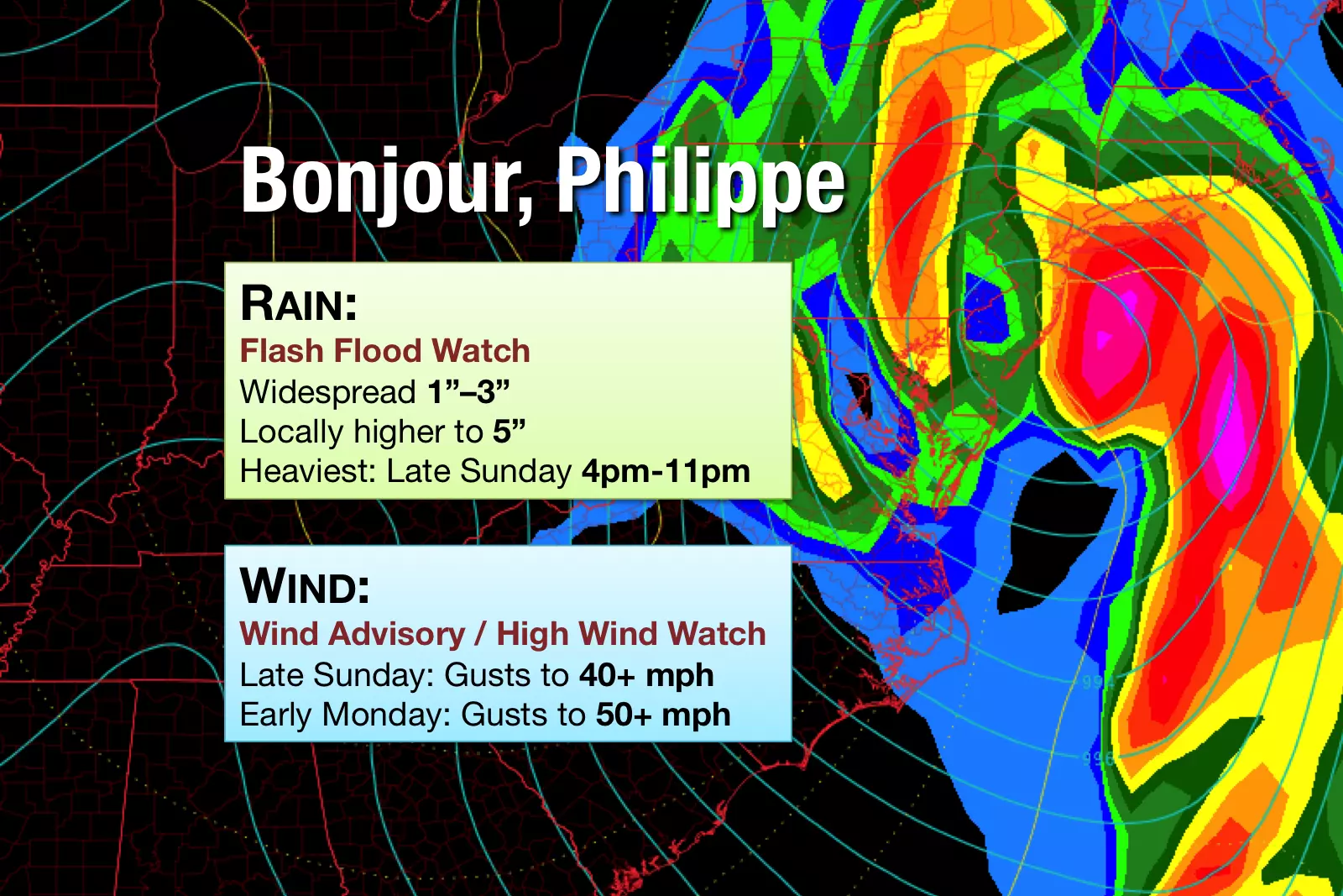
The National Weather Service has expanded the Flash Flood Watch to now include all 21 counties in New Jersey, in effect from Noon to Midnight Sunday. Several inches of rain may cause flash flooding, especially from torrential thunderstorms that sit over one area for an extended time. Streams and creeks may rise quickly, and roads may need to be closed due to water inundation.
A Wind Advisory has also been posted for all but the NE corner of New Jersey, where a High Wind Watch was issued instead. Peak winds will occur Monday morning.
The coastal flooding picture continues to look good, limited to 1 to 1.5 feet of surge. Minor flooding may occur at this afternoon's high tide cycle, but only in the most vulnerable, low-lying tidal areas.
Here is a rundown of what to expect for the rest of Sunday and Monday too:
Sunday Morning (8 a.m. to Noon)
Bands of moderate to occasionally heavy rain arrive from the west, spawned from the approaching cold front. Winds will remain manageable, out of the southeast up to about 20 mph.
Sunday Early Afternoon (Noon to 3 p.m.)
We should get a bit of a lull in the rain, between the initial frontal push and the approach of Philippe. There could still be areas of light to moderate rain around. The stiff southeast breeze will continue, up to 25 mph.
Sunday Late Afternoon (3 p.m. to 6 p.m.)
Here we go... Heavy tropical rains will spread into New Jersey from the south, as Tropical Storm Philippe approaches. Wind speeds will increase accordingly, gusting to 40+ mph.
Sunday Evening (6 p.m. to Midnight)
The brunt of the storm. Still very wet. Still very windy.
Monday Early Morning (Midnight to 5 a.m.)
Rain tapers by around Midnight, with only scattered areas of rain carrying over into Monday. Winds, however, will remain elevated overnight. Sustained to 20 mph, gusts to 30+ mph.
Monday Morning (5 a.m. to 10 a.m.)
As our wind direction shifts from southeasterly to a westerly direction, wind speeds will increase dramatically. Regular gusts between 35 and 50+ mph are expected. Meanwhile, scattered showers will come to an end by the end of this period.
The Rest of Monday
Dry, but still quite breezy and chilly. Winds 15 to 25 mph through the afternoon, with high temperatures limited to the 50s.
My Advice
If you have outdoor plans on Sunday, you may as well stick a fork in them. They're done. If you don't have to go anywhere Sunday, especially in the evening hours, I'd highly recommend just staying safe and sound at home. It's going to be downright nasty for most of the day.
Monday morning's commute is going to be equally awful given the fierce winds. You may want to set the alarm clock a few minutes early to allow yourself extra time.
Take a few minutes on Sunday — even in the soaking rain — to survey your yard and secure anything that may become a projectile in 50+ mph winds. That includes light patio furniture, garbage cans, tools, toys, and especially Halloween decorations.
Scattered power outages are possible during the height of the storm. While any downed lines should be resolved quickly as wind subsides late Monday, your power may be out for 24 hours or more.
Our weather, traffic, and news teams are on full alert today to report on storm conditions, road closures, power outages, and more. Follow us on social media, keep an eye on the web site, or download our mobile app for up-to-the-second info.
Dan Zarrow is Chief Meteorologist for Townsquare Media New Jersey. Follow him on Facebook or Twitter for the latest forecast and realtime weather updates.
More From New Jersey 101.5 FM


