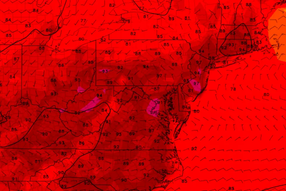
Heat Advisory for your back-to-work and back-to-school Tuesday
I'm baaaaack! After a refreshing and rejuvenating vacation, I have returned to the saddle of the weather center. And we've got some heat and humidity, some thunderstorms, and a pair of tropical storms to talk about.
Heat Wave
The calendar says early September, with climatological normal high temperatures around 80 and lows in the lower 60s. But we've got some true midsummer heat in the forecast. There are going to be some incredibly hot classrooms on this back-to-school week.
On this Tuesday morning, we're starting off with temperatures generally in the 70s. I've seen a few pockets of dense fog, reducing visibilities only slightly. Under mostly sunny skies, thermometers will cook into the 90s for most of the state today. It looks like a dry day, with very little wind to keep the warm air moving around unfortunately. You'll hopefully catch some relief at the Jersey Shore, with temperatures limited to the 80s.
Of course, when you add in the humidity factor to those 90+ degree temps, you get the heat index (or "feels like" temperature). Much of the state will likely see a heat index at or above 100 degrees Tuesday afternoon. As you know, that brand of heat can be hazardous to your health.
Therefore, a Heat Advisory has been issued for most of New Jersey:
--Through 9 p.m. Tuesday... Bergen, Essex, Hudson, Passaic, and Union counties
--11 a.m. to 7 p.m. Tuesday... Burlington, Camden, Gloucester, Hunterdon, Mercer, Middlesex, Monmouth, Morris, Ocean, Somerset, and Warren counties
--No Advisory... Atlantic, Cape May, Cumberland, Salem, and Sussex counties
We'll stay summery and sticky for Tuesday night, as low temperatures only dip into the lower to mid 70s once again. You'll see a few clouds overhead with patchy fog probable.
Wednesday's heat and humidity numbers look slightly less ferocious. Forecast high temperatures range from the upper 80s to lower 90s for most of the state. There will be a few extra clouds in the sky — let's call it partly sunny. And there could be a spot shower or thunderstorm at some point too. (But any rain cell that pops up should remain isolated.)
New Jersey will endure one more steamy day on Thursday, with most high temperatures back into the lower to mid 90s. Skies will progress from sun to clouds.
Cooldown
An approaching cold front will fire off scattered showers and thunderstorms starting Thursday afternoon — say around 3 p.m. in NW NJ, give or take. Everyone is prone to get wet at some point through Thursday evening, Thursday night, and early Friday morning.
Behind that front, cooler and drier air will settle over the Garden State on Friday. And I do mean cooler — models suggest that most of the state will be stuck in the 70s all day! While the thermometer will present a welcome taste of early Fall, it will not be crisp and dry as you might expect. Skies will remain mostly cloudy, with lingering showers.
In fact, current guidance suggests a persistent on-shore flow through the weekend. That would keep our skies overcast and temperatures cool (in the 70s). Additionally, it means additional showers will be possible. The GFS model paints a pretty wet scenario for the entire period from Thursday night through Tuesday morning. But I think that's overdone — I like the Euro's solution of only occasional showers, with pockets of dry weather along the way (especially on Sunday).
The Tropics
September is, on average, the peak of the Atlantic hurricane season. And, right on cue, a string of tropical waves has fired up — two of those waves have organized and intensified into tropical storms.
Tropical Storm Florence is way out there — on the order of 2,400 miles southeast of New Jersey. Latest guidance and the official National Hurricane Center forecast track keeps the storm east of Bermuda. So no weather impacts are anticipated here at home. But rough surf and rip current concerns are always possible with a storm swelling the Atlantic basin.
Meanwhile, Tropical Storm Gordon is in the middle of the Gulf of Mexico, packing 65 mph max sustained winds. As of the 5 a.m. update, the center of the storm is less than 200 miles due west of Tampa, Florida, moving to the west-northwest at 17 mph. Hurricane warnings have been posted for parts of the Alabama, Mississippi, and Louisiana coastlines as the storm approaches over the next 24 hours.
We'll have to keep an eye on where Gordon's moisture goes after landfall — it could produce or enhance any rain here in New Jersey through early next week.
Dan Zarrow is Chief Meteorologist for Townsquare Media New Jersey. Follow him on Facebook or Twitter for the latest forecast and realtime weather updates.
More From New Jersey 101.5 FM


