

Dry and seasonable weather Monday – rain returns to NJ Tuesday
For the second time in less than a week, we had some solid soaking rain pass through New Jersey thanks to the remnants of Tropical Storm Nestor. Top rainfall totals from soggy Sunday topped 2 inches in South Jersey (2.63" at Vineland, 2.08" at Fortescue). Combined with last Wednesday's steady rain, we've made a real dent in our recent drought spiral. Especially considering there is another (brief) batch of rain on the horizon for the entire Garden State.
Nestor is gone now, and radar is showing dry weather across all 21 counties of New Jersey on this Monday morning. It looks like some widely scattered spots of fog have developed. Temperatures are hovering right around 50 degrees across the state.
Skies have already cleared considerably, and we should enjoy abundant sunshine with occasional clouds Monday. We'll be dry from this point forward, with seasonable (near-normal) high temperatures in the lower to mid 60s.
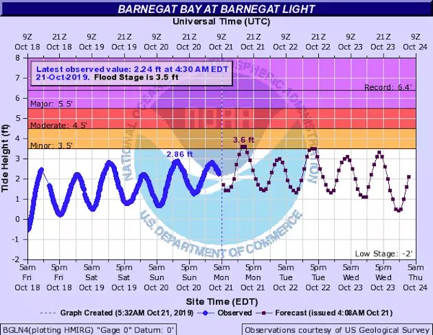
The only thing to watch — and it's really not going to be a big deal at all — is a higher-than-usual high tide Monday afternoon. We're talking a couple of inches higher, which would only cause localized minor coastal flooding (if that). Hardly worth mentioning, but you know I like to be comprehensive!
Increasing clouds are in the forecast for Monday night, as low temperatures dip to around 50 degrees. Cool, but not too chilly.
Things turn upside-down and unsettled again on Tuesday, as a cold front slowly approaches New Jersey. A few of our short-range forecast models show spotty showers developing over the Garden State starting Tuesday morning. I don't think the day will be a total washout though (especially if you believe the drier GFS model). At the very least, the entire day will be noticeably cloudier and cooler, with highs only in the upper 50s to lower 60s.
The front itself will arrive Tuesday evening, delivering a quick (but potent) round of rain (and thunderstorms) between sunset and sunrise. You may hear/feel a quick burst of wind too as our new air mass arrives. Rainfall totals are expected to remain below a half-inch statewide.
As showers wrap up early Wednesday morning and skies clear, we'll flip right back to beautiful weather again. Wednesday will be sunny and breezy, with high temperatures in the mid 60s. That's about "par for the course" for the last third of October.
Thursday's forecast also looks fantastic, with more sunshine and mid 60s.
Most of Friday looks fine, with clouds mid 60s. Our next storm system is set to arrive Friday evening through Saturday morning with another batch of rain. The Euro model in particular shows this wet weather will be limited to North Jersey, but I really wouldn't rule out raindrops anywhere in the state to start the weekend.
Skies will clear late Saturday, and Sunday looks great. But I caution it's still early in the week — we'll really start focusing on the weekend forecast around midweek.
Dan Zarrow is Chief Meteorologist for Townsquare Media New Jersey. Follow him on Facebook or Twitter for the latest forecast and realtime weather updates.
More From New Jersey 101.5 FM


