

A taste of summertime for NJ Friday: Steamy and possibly stormy
It is NOT cool outside this morning. You will feel the humidity the instant you walk outside. It's going to be a steamy day for sure. And probably stormy, at least for part of the Garden State. But then the weekend forecast looks wonderful.
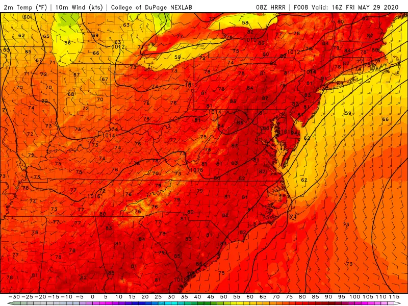
We're starting off Friday morning with temperatures close to 70 degrees. (It's a little cooler and more comfortable along the Jersey Shore.) This would be typical for a mid-summer morning. But here in late May, it's about 15 degrees above normal.
Widespread lower 80s are expected across most of New Jersey Friday afternoon. (Some models even go as high as 87 degrees — steamy and sweaty!) With dew points near 70, we can even talk about the heat index — that's the warm weather "feels like" or "apparent" temperature — likely between 85 and 90 degrees. That is nowhere near dangerous heat territory, but definitely feeling summer-ish. Be sure to dress for the weather, stay cool, and stay hydrated.
Skies will be mostly cloudy Friday. But a few pops of sunshine are likely, which will help cook the juicy atmosphere. So, a few showers and thunderstorms are expected to popup throughout the day. Not everyone in the state will see a storm. But if you do, you'll face localized downpours, lightning, and maybe a gust of wind.
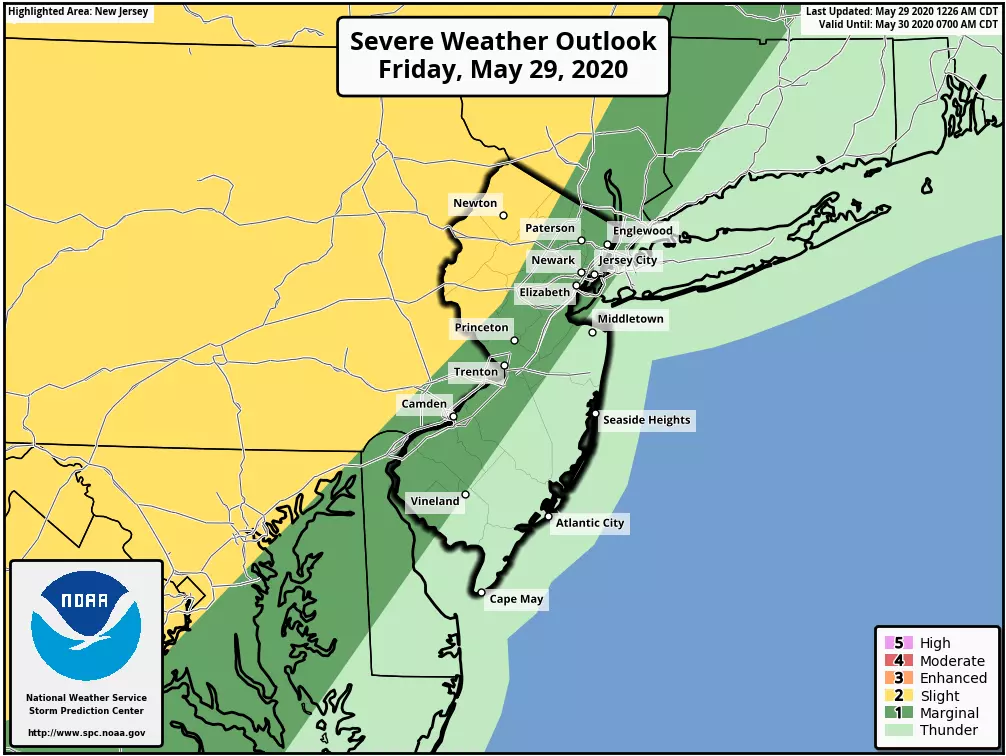
The best chance of rain will come Friday evening, as a cold front approaches from the west. One more line of potentially strong thunderstorms is likely, driving from northwest to southeast. These storms will be capable of producing downpours, lightning, wind, and hail.

The big question, however, is how long will those "grand finale" storms hold together. There is a strong consensus among our forecast models showing a nearly complete fizzle before they reach the coast. Therefore, the biggest threat for severe weather remains over northwestern New Jersey. (I actually think the Storm Prediction Center's severe weather outlook graphic here does an excellent job of pinpointing the greatest potential for violent weather (yellow and dark green).)
As final showers exit the Garden State early Saturday morning, we'll be under the influence of our new air mass. It will be muggy in the morning, with low temps only falling into the upper 60s. But then humidity will begin to drop dramatically Saturday — dew points should fall from near 70 early into the 40s by Saturday night. Much more comfortable.
And here is even better news: the decreasing humidity will accompany increasing sunshine Saturday! It will still be nice and warm, with high temperatures mainly in the lower 80s across New Jersey. Even the Jersey Shore, which has been stuck in the 60s all week, should touch 70+ degrees Saturday afternoon.
Sunday will be the cooler day of the weekend, but that's not necessarily bad news. Morning lows in the 50s (40s to the northwest). Afternoon highs in the lower 70s (upper 60s to the northwest). We'll enjoy lots of sunshine, with a refreshing northwesterly breeze (10 to 20 mph).
About the same for Monday. Partly sunny, dry, and near 70. Cooler than normal for the first day of June, but still quite pleasant.
The forecast for next week looks rather benign, with only minor rain chances Tuesday night and Wednesday night. Temperatures will stay in the 70s for the first half of the week, potentially coming close to 80 degrees again by the weekend.
Have yourself a great weekend! Be safe and stay healthy, my friends!
Dan Zarrow is Chief Meteorologist for Townsquare Media New Jersey. Follow him on Facebook or Twitter for the latest forecast and realtime weather updates.
More From New Jersey 101.5 FM


